Property Record
11 Spruce Ave, Claremont, NH 03743
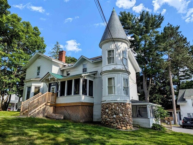
This Property Is For Sale
NEARBY LISTINGS FOR SALE OR LEASE
-
-
View all Claremont listings for sale on LoopNet.com
Property Detail
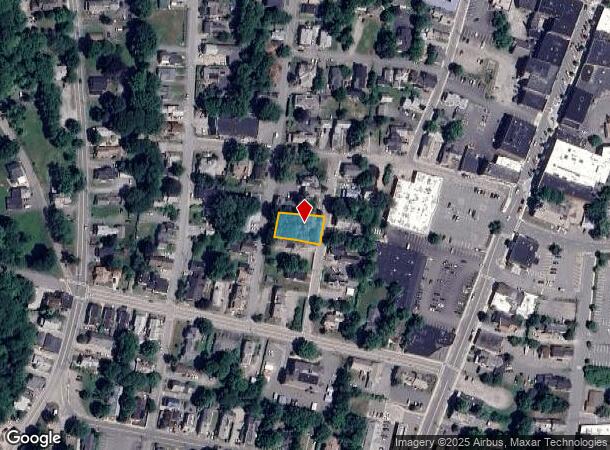
11 Spruce Ave
Claremont-Lebanon, NH-VT
Sullivan
CLMN-000119-000000-000318
New Hampshire
Sfr
0.24 AC
X
Concord/New Hampshire North Area
33019C0280E
Other Market Areas
3,620 SF
DEMOGRAPHICS near 11 Spruce Ave
1 Mile
3 Mile
5 Mile
2024 Total Population
9,125
14,158
16,696
2029 Population
9,954
15,412
18,083
Pop Growth 2024-2029
+ 9.08%
+ 8.86%
+ 8.31%
Average Age
41
42
43
2024 Total Households
3,907
6,000
7,092
HH Growth 2024-2029
+ 8.50%
+ 8.20%
+ 7.66%
Median Household Inc
$52,222
$56,978
$58,884
Avg Household Size
2.20
2.30
2.30
2024 Avg HH Vehicles
2.00
2.00
2.00
Median Home Value
$195,056
$187,438
$201,572
Median Year Built
1954
1960
1964
Nearby Places
Map Layers
Map Styles
 Street
 Aerial
- Restaurants
- Banks
- Shops
- Fitness
- Groceries
PUBLIC TRANSPORTATION
COMMUTER RAIL
DRIVE
WALK
Distance
6 min
2.5 mi
Nearby Properties
Address
Land Use
TOTAL SIZE
Lot Size
Zoning
Address
Land Use
TOTAL SIZE
Lot Size
Zoning
98,622 SF
9.03 AC
MUHD
Address
Land Use
TOTAL SIZE
Lot Size
Zoning
73,663 SF
19.48 AC
R1
Address
Land Use
TOTAL SIZE
Lot Size
Zoning
163,903 SF
31.35 AC
B2
Address
Land Use
TOTAL SIZE
Lot Size
Zoning
64,201 SF
3.18 AC
CR2
Address
Land Use
TOTAL SIZE
Lot Size
Zoning
124,339 SF
1.59 AC
MU
Address
Land Use
TOTAL SIZE
Lot Size
Zoning
6,300 SF
16.43 AC
CR2
Address
Land Use
TOTAL SIZE
Lot Size
Zoning
112,986 SF
14 AC
B2
Address
Land Use
TOTAL SIZE
Lot Size
Zoning
124,536 SF
17.61 AC
B2
Address
Land Use
TOTAL SIZE
Lot Size
Zoning
73,446 SF
72.98 AC
RR
Address
Land Use
TOTAL SIZE
Lot Size
Zoning
104,633 SF
10.48 AC
B2
Address
Land Use
TOTAL SIZE
Lot Size
Zoning
246,345 SF
42.53 AC
I2
Address
Land Use
TOTAL SIZE
Lot Size
Zoning
14,980 SF
6.49 AC
R2
Address
Land Use
TOTAL SIZE
Lot Size
Zoning
3,304 SF
58 AC
I2
Address
Land Use
TOTAL SIZE
Lot Size
Zoning
110,069 SF
10.40 AC
B2
Address
Land Use
TOTAL SIZE
Lot Size
Zoning
24,477 SF
3.69 AC
CR2
Address
Land Use
TOTAL SIZE
Lot Size
Zoning
35,095 SF
3.03 AC
B2
Address
Land Use
TOTAL SIZE
Lot Size
Zoning
7,868 SF
5.43 AC
B2
Address
Land Use
TOTAL SIZE
Lot Size
Zoning
46,410 SF
2.56 AC
MU
Address
Land Use
TOTAL SIZE
Lot Size
Zoning
72,925 SF
27.69 AC
R2
Address
Land Use
TOTAL SIZE
Lot Size
Zoning
45,723 SF
3.49 AC
R1
Address
Land Use
TOTAL SIZE
Lot Size
Zoning
12,498 SF
4.18 AC
MU
Address
Land Use
TOTAL SIZE
Lot Size
Zoning
150,192 SF
6.78 AC
B2
Address
Land Use
TOTAL SIZE
Lot Size
Zoning
44,342 SF
13.29 AC
B2
Address
Land Use
TOTAL SIZE
Lot Size
Zoning
1,700 SF
130.86 AC
I1
Address
Land Use
TOTAL SIZE
Lot Size
Zoning
68,135 SF
1.61 AC
CR2
Address
Land Use
TOTAL SIZE
Lot Size
Zoning
24,236 SF
0.41 AC
MU
Address
Land Use
TOTAL SIZE
Lot Size
Zoning
8,482 SF
0.32 AC
MU
Address
Land Use
TOTAL SIZE
Lot Size
Zoning
84,192 SF
0.97 AC
MU
Address
Land Use
TOTAL SIZE
Lot Size
Zoning
37,082 SF
6.35 AC
R1
Address
Land Use
TOTAL SIZE
Lot Size
Zoning
28,444 SF
24.10 AC
B2
The World's #1 Commercial Real Estate Marketplace
Connect with us
© 2025 CoStar Group
The information above has been obtained from sources believed reliable. While we do not doubt its accuracy we have not verified it and make no guarantee, warranty or representation about it. It is your responsibility to independently confirm its accuracy and completeness. Any projections, opinions, assumptions, or estimates used are for example only and do not represent the current or future performance of the property. The value of this transaction to you depends on tax and other factors which should be evaluated by your tax, financial, and legal advisors. You and your advisors should conduct a careful, independent investigation of the property to determine to your satisfaction the suitability of the property for your needs.