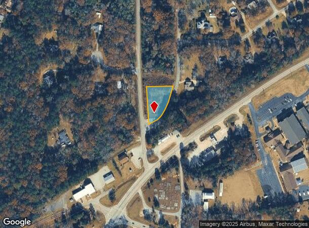
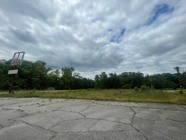
Property Record
11 Swint Loop, Ellerslie, GA 31807

NEARBY LISTINGS FOR SALE OR LEASE
-
-
View all Ellerslie listings for sale on LoopNet.com
Property Detail
11 Swint Loop
Columbus, GA-AL
Ac 24000
081A036
DIST 18 LL 155
Commercialnec
Harris
X
Georgia
13145C0220C
155
2025
1.02 AC
2025
Harris County
120404
Columbus GA
2,112 SF
DEMOGRAPHICS near 11 Swint Loop
1 Mile
3 Mile
5 Mile
2024 Total Population
1,222
5,462
11,884
2029 Population
1,376
6,159
13,062
Pop Growth 2024-2029
+ 12.60%
+ 12.76%
+ 9.91%
Average Age
41
41
40
2024 Total Households
427
1,901
4,140
HH Growth 2024-2029
+ 12.18%
+ 12.52%
+ 9.83%
Median Household Inc
$103,000
$98,636
$97,074
Avg Household Size
2.80
2.80
2.80
2024 Avg HH Vehicles
3.00
3.00
3.00
Median Home Value
$264,583
$290,179
$302,764
Median Year Built
1997
2000
2000
Nearby Places
Map Layers
Map Styles
 Street
 Aerial
- Restaurants
- Banks
- Shops
- Fitness
- Groceries
PUBLIC TRANSPORTATION
AIRPORT
Columbus
DRIVE
WALK
Distance
Columbus
19 min
13.6 mi
Freight Ports
Port of Panama City
DRIVE
WALK
Distance
Port of Panama City
255 min
201.1 mi
SALE & LEASE HISTORY
LISTING DATE
SALE/LEASE

May 26, 2023
For Sale
Jan 24, 2018
For Sale
Nearby Properties
Address
Land Use
TOTAL SIZE
Lot Size
Zoning
Address
Land Use
TOTAL SIZE
Lot Size
Zoning
34,872 SF
12.95 AC
001
Address
Land Use
TOTAL SIZE
Lot Size
Zoning
58,144 SF
82.42 AC
004
Address
Land Use
TOTAL SIZE
Lot Size
Zoning
9,090 SF
1.56 AC
002
Address
Land Use
TOTAL SIZE
Lot Size
Zoning
14,437 SF
10.02 AC
003
Address
Land Use
TOTAL SIZE
Lot Size
Zoning
6,900 SF
41.67 AC
004
Address
Land Use
TOTAL SIZE
Lot Size
Zoning
3,200 SF
2.41 AC
002
Address
Land Use
TOTAL SIZE
Lot Size
Zoning
1,032 SF
3.34 AC
003
Address
Land Use
TOTAL SIZE
Lot Size
Zoning
2,786 SF
118.26 AC
004
Address
Land Use
TOTAL SIZE
Lot Size
Zoning
95.07 AC
004
Address
Land Use
TOTAL SIZE
Lot Size
Zoning
4,829 SF
15.28 AC
002
Address
Land Use
TOTAL SIZE
Lot Size
Zoning
107.08 AC
004
Address
Land Use
TOTAL SIZE
Lot Size
Zoning
8,400 SF
1.20 AC
001
Address
Land Use
TOTAL SIZE
Lot Size
Zoning
73.35 AC
004
Address
Land Use
TOTAL SIZE
Lot Size
Zoning
2,670 SF
1.69 AC
002
Address
Land Use
TOTAL SIZE
Lot Size
Zoning
3,645 SF
1.80 AC
001
Address
Land Use
TOTAL SIZE
Lot Size
Zoning
2,304 SF
43.91 AC
004
Address
Land Use
TOTAL SIZE
Lot Size
Zoning
4,800 SF
2 AC
002
Address
Land Use
TOTAL SIZE
Lot Size
Zoning
47.62 AC
004
Address
Land Use
TOTAL SIZE
Lot Size
Zoning
37.83 AC
004
Address
Land Use
TOTAL SIZE
Lot Size
Zoning
4,792 SF
4.27 AC
001
Address
Land Use
TOTAL SIZE
Lot Size
Zoning
39.18 AC
004
Address
Land Use
TOTAL SIZE
Lot Size
Zoning
43.28 AC
004
Address
Land Use
TOTAL SIZE
Lot Size
Zoning
2,722 SF
1.09 AC
002
Address
Land Use
TOTAL SIZE
Lot Size
Zoning
3,240 SF
0.32 AC
004
Address
Land Use
TOTAL SIZE
Lot Size
Zoning
3,235 SF
4.50 AC
002
Address
Land Use
TOTAL SIZE
Lot Size
Zoning
2,145 SF
1 AC
001
Address
Land Use
TOTAL SIZE
Lot Size
Zoning
1,797 SF
29.39 AC
004
Address
Land Use
TOTAL SIZE
Lot Size
Zoning
24.15 AC
004
Address
Land Use
TOTAL SIZE
Lot Size
Zoning
1,296 SF
0.43 AC
002
Address
Land Use
TOTAL SIZE
Lot Size
Zoning
2,616 SF
1.07 AC
002
The World's #1 Commercial Real Estate Marketplace
Connect with us
© 2025 CoStar Group
The information above has been obtained from sources believed reliable. While we do not doubt its accuracy we have not verified it and make no guarantee, warranty or representation about it. It is your responsibility to independently confirm its accuracy and completeness. Any projections, opinions, assumptions, or estimates used are for example only and do not represent the current or future performance of the property. The value of this transaction to you depends on tax and other factors which should be evaluated by your tax, financial, and legal advisors. You and your advisors should conduct a careful, independent investigation of the property to determine to your satisfaction the suitability of the property for your needs.