Property Record
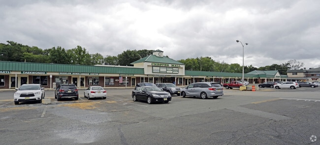
11 W Main St, Chester, NJ 07930

NEARBY LISTINGS FOR SALE OR LEASE
Property Detail
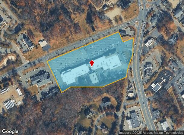
11 W Main St
Newark, NJ
Morris
06-00133-0000-00005
New Jersey
Commercialnec
5
2024
7.25 AC
2025
Western Morris
045901
Northern New Jersey
65,914 SF
DEMOGRAPHICS near 11 W Main St
1 Mile
3 Mile
5 Mile
2024 Total Population
2,281
9,791
31,917
2029 Population
2,270
9,748
31,794
Pop Growth 2024-2029
(0.48%)
(0.44%)
(0.39%)
Average Age
43
43
42
2024 Total Households
829
3,421
11,049
HH Growth 2024-2029
(0.48%)
(0.44%)
(0.36%)
Median Household Inc
$143,923
$156,715
$164,804
Avg Household Size
2.70
2.80
2.80
2024 Avg HH Vehicles
2.00
2.00
2.00
Median Home Value
$666,465
$648,537
$581,314
Median Year Built
1972
1976
1975
Nearby Places
Map Layers
Map Styles
 Street
 Aerial
- Restaurants
- Banks
- Shops
- Fitness
- Groceries
PUBLIC TRANSPORTATION
COMMUTER RAIL
Gladstone (Morris & Essex Gladstone Branch - NJ Transit Commuter Rail (NJ Transit))
DRIVE
WALK
Distance
Gladstone (Morris & Essex Gladstone Branch - NJ Transit Commuter Rail (NJ Transit))
9 min
4.9 mi
Peapack (Morris & Essex Gladstone Branch - NJ Transit Commuter Rail (NJ Transit))
DRIVE
WALK
Distance
Peapack (Morris & Essex Gladstone Branch - NJ Transit Commuter Rail (NJ Transit))
10 min
6.0 mi
AIRPORT
Newark Liberty International
DRIVE
WALK
Distance
Newark Liberty International
48 min
34.6 mi
Freight Ports
Maher Terminal
DRIVE
WALK
Distance
Maher Terminal
51 min
35.1 mi
SALE & LEASE HISTORY
LISTING DATE
SALE/LEASE

Sep 24, 2016
For Lease
Apr 05, 2023
For Lease
Nearby Properties
Address
Land Use
TOTAL SIZE
Lot Size
Zoning
Address
Land Use
TOTAL SIZE
Lot Size
Zoning
242 AC
G-I
Address
Land Use
TOTAL SIZE
Lot Size
Zoning
21.56 AC
B-3
Address
Land Use
TOTAL SIZE
Lot Size
Zoning
50.50 AC
R-5
Address
Land Use
TOTAL SIZE
Lot Size
Zoning
104,682 SF
8.96 AC
B-3
Address
Land Use
TOTAL SIZE
Lot Size
Zoning
720 SF
1,022.40 AC
R-2
Address
Land Use
TOTAL SIZE
Lot Size
Zoning
27.40 AC
P
Address
Land Use
TOTAL SIZE
Lot Size
Zoning
610.04 AC
R-5
Address
Land Use
TOTAL SIZE
Lot Size
Zoning
39.63 AC
P
Address
Land Use
TOTAL SIZE
Lot Size
Zoning
1,036 SF
285.42 AC
P
Address
Land Use
TOTAL SIZE
Lot Size
Zoning
52,027 SF
33.23 AC
R-2
Address
Land Use
TOTAL SIZE
Lot Size
Zoning
1,516 SF
40.74 AC
R-LD
Address
Land Use
TOTAL SIZE
Lot Size
Zoning
3,328 SF
12.65 AC
B-2
Address
Land Use
TOTAL SIZE
Lot Size
Zoning
222.10 AC
R-3
Address
Land Use
TOTAL SIZE
Lot Size
Zoning
213.55 AC
R-5
Address
Land Use
TOTAL SIZE
Lot Size
Zoning
10,889 SF
2.40 AC
R-HD
Address
Land Use
TOTAL SIZE
Lot Size
Zoning
146 AC
P
Address
Land Use
TOTAL SIZE
Lot Size
Zoning
9.52 AC
IL
Address
Land Use
TOTAL SIZE
Lot Size
Zoning
31,680 SF
3.23 AC
OP
Address
Land Use
TOTAL SIZE
Lot Size
Zoning
34.66 AC
R-5
Address
Land Use
TOTAL SIZE
Lot Size
Zoning
28,260 SF
2.84 AC
B-3
Address
Land Use
TOTAL SIZE
Lot Size
Zoning
64.01 AC
I
Address
Land Use
TOTAL SIZE
Lot Size
Zoning
151.11 AC
R-2
Address
Land Use
TOTAL SIZE
Lot Size
Zoning
22,907 SF
1.88 AC
C-2
Address
Land Use
TOTAL SIZE
Lot Size
Zoning
1,331 SF
7.44 AC
R-2
Address
Land Use
TOTAL SIZE
Lot Size
Zoning
44 AC
BE
Address
Land Use
TOTAL SIZE
Lot Size
Zoning
103.72 AC
IL
Address
Land Use
TOTAL SIZE
Lot Size
Zoning
15,040 SF
1.44 AC
B-3
Address
Land Use
TOTAL SIZE
Lot Size
Zoning
7,326 SF
11.91 AC
R-5
Address
Land Use
TOTAL SIZE
Lot Size
Zoning
3,360 SF
2.04 AC
R-HD
The World's #1 Commercial Real Estate Marketplace
Connect with us
© 2026 CoStar Group
The information above has been obtained from sources believed reliable. While we do not doubt its accuracy we have not verified it and make no guarantee, warranty or representation about it. It is your responsibility to independently confirm its accuracy and completeness. Any projections, opinions, assumptions, or estimates used are for example only and do not represent the current or future performance of the property. The value of this transaction to you depends on tax and other factors which should be evaluated by your tax, financial, and legal advisors. You and your advisors should conduct a careful, independent investigation of the property to determine to your satisfaction the suitability of the property for your needs.