Property Record
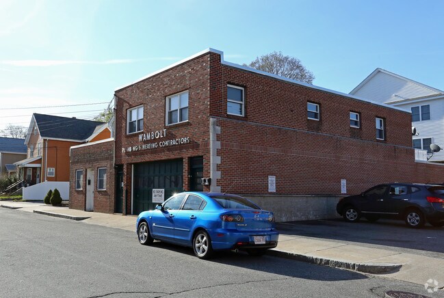
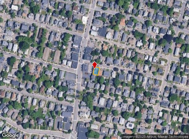
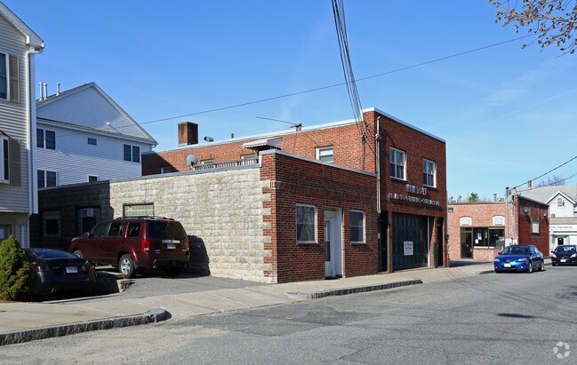
11 Wadsworth Ave, Waltham, MA 02453
NEARBY LISTINGS FOR SALE OR LEASE
Property Detail
11 Wadsworth Ave
WALT-000077-000017-000002
Middlesex
Commercialofficeresidentialmixeduse
Massachusetts
X
2
25017C0551F
0.08 AC
0
Waltham/Watertown
2025
Boston
368600
Boston-Cambridge-Newton, MA-NH
4,585 SF
DEMOGRAPHICS near 11 Wadsworth Ave
1 Mile
3 Mile
5 Mile
2024 Total Population
27,627
128,741
305,446
2029 Population
27,183
127,055
300,571
Pop Growth 2024-2029
(1.61%)
(1.31%)
(1.60%)
Average Age
38
41
40
2024 Total Households
11,694
51,061
118,721
HH Growth 2024-2029
(1.63%)
(1.42%)
(1.81%)
Median Household Inc
$102,478
$122,774
$129,549
Avg Household Size
2.30
2.40
2.40
2024 Avg HH Vehicles
2.00
2.00
2.00
Median Home Value
$744,835
$842,044
$922,730
Median Year Built
1949
1950
1951
Nearby Places
Map Layers
Map Styles
 Street
 Aerial
- Restaurants
- Banks
- Shops
- Fitness
- Groceries
PUBLIC TRANSPORTATION
TRANSIT/SUBWAY
Waltham (Fitchburg/South Acton Line - Massachusetts Bay Transportation Authority Commuter Rail (Purple Line))
DRIVE
WALK
Distance
Waltham (Fitchburg/South Acton Line - Massachusetts Bay Transportation Authority Commuter Rail (Purple Line))
3 min
17 min
0.9 mi
COMMUTER RAIL
DRIVE
WALK
Distance
4 min
17 min
0.9 mi
Waltham (Fitchburg/South Acton Line - Massachusetts Bay Transportation Authority Commuter Rail (Purple Line))
DRIVE
WALK
Distance
Waltham (Fitchburg/South Acton Line - Massachusetts Bay Transportation Authority Commuter Rail (Purple Line))
3 min
17 min
0.9 mi
AIRPORT
General Edward Lawrence Logan International
DRIVE
WALK
Distance
General Edward Lawrence Logan International
24 min
13.8 mi
Worcester Regional
DRIVE
WALK
Distance
Worcester Regional
58 min
40.1 mi
Freight Ports
Port of Boston
DRIVE
WALK
Distance
Port of Boston
23 min
12.1 mi
Nearby Properties
Address
Land Use
TOTAL SIZE
Lot Size
Zoning
Address
Land Use
TOTAL SIZE
Lot Size
Zoning
447,312 SF
62.01 AC
Address
Land Use
TOTAL SIZE
Lot Size
Zoning
220,671 SF
2.52 AC
I-2
Address
Land Use
TOTAL SIZE
Lot Size
Zoning
165,986 SF
4.32 AC
Address
Land Use
TOTAL SIZE
Lot Size
Zoning
105,982 SF
4.50 AC
Address
Land Use
TOTAL SIZE
Lot Size
Zoning
30,170 SF
19 AC
SR2
Address
Land Use
TOTAL SIZE
Lot Size
Zoning
387,965 SF
3.90 AC
Address
Land Use
TOTAL SIZE
Lot Size
Zoning
21.52 AC
Address
Land Use
TOTAL SIZE
Lot Size
Zoning
317,256 SF
17.48 AC
Address
Land Use
TOTAL SIZE
Lot Size
Zoning
234,814 SF
4.06 AC
Address
Land Use
TOTAL SIZE
Lot Size
Zoning
293,084 SF
5.01 AC
1
Address
Land Use
TOTAL SIZE
Lot Size
Zoning
73.10 AC
SA
Address
Land Use
TOTAL SIZE
Lot Size
Zoning
238,065 SF
1.79 AC
Address
Land Use
TOTAL SIZE
Lot Size
Zoning
272,445 SF
6.40 AC
Address
Land Use
TOTAL SIZE
Lot Size
Zoning
179,834 SF
8.57 AC
PUB
Address
Land Use
TOTAL SIZE
Lot Size
Zoning
269,692 SF
15.37 AC
Address
Land Use
TOTAL SIZE
Lot Size
Zoning
402,419 SF
73.98 AC
BB
Address
Land Use
TOTAL SIZE
Lot Size
Zoning
344,469 SF
54.49 AC
Address
Land Use
TOTAL SIZE
Lot Size
Zoning
6.51 AC
PSCD
Address
Land Use
TOTAL SIZE
Lot Size
Zoning
293,195 SF
11.55 AC
BU5
Address
Land Use
TOTAL SIZE
Lot Size
Zoning
391,781 SF
8.22 AC
Address
Land Use
TOTAL SIZE
Lot Size
Zoning
3.86 AC
Address
Land Use
TOTAL SIZE
Lot Size
Zoning
164,072 SF
43.80 AC
Address
Land Use
TOTAL SIZE
Lot Size
Zoning
212,684 SF
54.49 AC
Address
Land Use
TOTAL SIZE
Lot Size
Zoning
30.69 AC
Address
Land Use
TOTAL SIZE
Lot Size
Zoning
21.99 AC
Address
Land Use
TOTAL SIZE
Lot Size
Zoning
124,950 SF
1.69 AC
Address
Land Use
TOTAL SIZE
Lot Size
Zoning
36,868 SF
3.41 AC
MAN
Address
Land Use
TOTAL SIZE
Lot Size
Zoning
144,584 SF
4.86 AC
PUB
Address
Land Use
TOTAL SIZE
Lot Size
Zoning
210,423 SF
26.39 AC
Address
Land Use
TOTAL SIZE
Lot Size
Zoning
197,400 SF
4.29 AC
The World's #1 Commercial Real Estate Marketplace
Connect with us
© 2025 CoStar Group
The information above has been obtained from sources believed reliable. While we do not doubt its accuracy we have not verified it and make no guarantee, warranty or representation about it. It is your responsibility to independently confirm its accuracy and completeness. Any projections, opinions, assumptions, or estimates used are for example only and do not represent the current or future performance of the property. The value of this transaction to you depends on tax and other factors which should be evaluated by your tax, financial, and legal advisors. You and your advisors should conduct a careful, independent investigation of the property to determine to your satisfaction the suitability of the property for your needs.