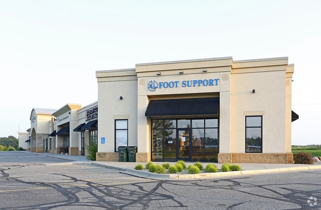
Property Record
110 14Th Ave E, Sartell, MN 56377


NEARBY LISTINGS FOR SALE OR LEASE
Property Detail
110 14Th Ave E
St. Cloud, MN
Prairie Meadow Estates
18.00508.00
SECT-15 TWP-036 RANGE-031 PRAIRIE MEADOW ESTATES LOT-002 BLOCK-001 LYING SWLY OF FOLL LINE COMM AT SE COR LOT 2 TH NELY ALONG
Commercialnec
Benton
X
Minnesota
27145C0631E
2,132
2025
0.71 AC
2025
Benton County
020206
Minneapolis/St Paul
6,780 SF
DEMOGRAPHICS near 110 14Th Ave E
1 Mile
3 Mile
5 Mile
2024 Total Population
5,481
34,911
85,590
2029 Population
5,421
35,512
87,765
Pop Growth 2024-2029
(1.09%)
+ 1.72%
+ 2.54%
Average Age
42
38
37
2024 Total Households
2,415
14,257
34,097
HH Growth 2024-2029
(0.99%)
+ 1.75%
+ 2.62%
Median Household Inc
$53,731
$61,124
$58,591
Avg Household Size
2.10
2.40
2.30
2024 Avg HH Vehicles
2.00
2.00
2.00
Median Home Value
$212,500
$220,288
$196,180
Median Year Built
1987
1990
1983
Nearby Places
Map Layers
Map Styles
 Street
 Aerial
- Restaurants
- Banks
- Shops
- Fitness
- Groceries
PUBLIC TRANSPORTATION
COMMUTER RAIL
St. Cloud Amtrak Station (Empire Builder - Amtrak)
DRIVE
WALK
Distance
St. Cloud Amtrak Station (Empire Builder - Amtrak)
8 min
4.8 mi
Freight Ports
Port Milwaukee
DRIVE
WALK
Distance
Port Milwaukee
455 min
406.3 mi
SALE & LEASE HISTORY
LISTING DATE
SALE/LEASE

May 23, 2017
For Lease
Aug 12, 2019
For Sale
Apr 02, 2022
For Lease
Nearby Properties
Address
Land Use
TOTAL SIZE
Lot Size
Zoning
Address
Land Use
TOTAL SIZE
Lot Size
Zoning
16.60 AC
MD
Address
Land Use
TOTAL SIZE
Lot Size
Zoning
362,000 SF
86.20 AC
Address
Land Use
TOTAL SIZE
Lot Size
Zoning
250,584 SF
77.75 AC
Address
Land Use
TOTAL SIZE
Lot Size
Zoning
183,964 SF
39.05 AC
Address
Land Use
TOTAL SIZE
Lot Size
Zoning
10,800 SF
24.94 AC
Address
Land Use
TOTAL SIZE
Lot Size
Zoning
Address
Land Use
TOTAL SIZE
Lot Size
Zoning
11.82 AC
Address
Land Use
TOTAL SIZE
Lot Size
Zoning
30,096 SF
8.47 AC
Address
Land Use
TOTAL SIZE
Lot Size
Zoning
365,299 SF
28.68 AC
R1
Address
Land Use
TOTAL SIZE
Lot Size
Zoning
252,469 SF
35 AC
Address
Land Use
TOTAL SIZE
Lot Size
Zoning
10.46 AC
Address
Land Use
TOTAL SIZE
Lot Size
Zoning
149,778 SF
7.86 AC
Address
Land Use
TOTAL SIZE
Lot Size
Zoning
184,285 SF
13.37 AC
Address
Land Use
TOTAL SIZE
Lot Size
Zoning
88,000 SF
37.63 AC
Address
Land Use
TOTAL SIZE
Lot Size
Zoning
Address
Land Use
TOTAL SIZE
Lot Size
Zoning
232,274 SF
2.94 AC
R3
Address
Land Use
TOTAL SIZE
Lot Size
Zoning
15.78 AC
Address
Land Use
TOTAL SIZE
Lot Size
Zoning
105,123 SF
36.87 AC
R1
Address
Land Use
TOTAL SIZE
Lot Size
Zoning
127,460 SF
5 AC
Address
Land Use
TOTAL SIZE
Lot Size
Zoning
6.61 AC
Address
Land Use
TOTAL SIZE
Lot Size
Zoning
25,608 SF
6.96 AC
R5
Address
Land Use
TOTAL SIZE
Lot Size
Zoning
36,393 SF
6.28 AC
Address
Land Use
TOTAL SIZE
Lot Size
Zoning
9.75 AC
Address
Land Use
TOTAL SIZE
Lot Size
Zoning
197,115 SF
18.23 AC
Address
Land Use
TOTAL SIZE
Lot Size
Zoning
18,554 SF
8.41 AC
Address
Land Use
TOTAL SIZE
Lot Size
Zoning
29,349 SF
4.83 AC
Address
Land Use
TOTAL SIZE
Lot Size
Zoning
43,302 SF
5.67 AC
Address
Land Use
TOTAL SIZE
Lot Size
Zoning
3.89 AC
Address
Land Use
TOTAL SIZE
Lot Size
Zoning
10.96 AC
The World's #1 Commercial Real Estate Marketplace
Connect with us
© 2026 CoStar Group
The information above has been obtained from sources believed reliable. While we do not doubt its accuracy we have not verified it and make no guarantee, warranty or representation about it. It is your responsibility to independently confirm its accuracy and completeness. Any projections, opinions, assumptions, or estimates used are for example only and do not represent the current or future performance of the property. The value of this transaction to you depends on tax and other factors which should be evaluated by your tax, financial, and legal advisors. You and your advisors should conduct a careful, independent investigation of the property to determine to your satisfaction the suitability of the property for your needs.