Property Record
110 Cascade Dr, San Antonio, TX 78220

Save to a Folder
{{folder.Name}}
{{folder.ListingIds.length}} Properties
{{folder.ListingIds.length}} Property
Create a New Folder
Current Lease Availabilities
Property Detail
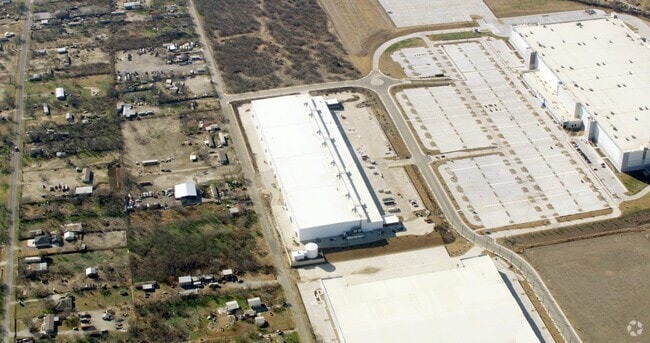
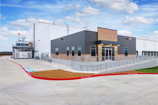
110 Cascade Dr
San Antonio-New Braunfels, TX
NCB 17995 (SFIP UT 7 & 8), BLOCK 2 LOT 7 2022- NEW PER PLAT 20002/758, FILED 06-04-2021
17995-002-0070
BEXAR
Shipyard
Texas
B and X Area of moderate flood hazard, usually the area between the limits of the 100-year and 500-year floods.
7
2025
16.96 AC
2025
South
131000
San Antonio
690,500 SF
NEARBY LISTINGS FOR SALE OR LEASE
DEMOGRAPHICS near 110 Cascade Dr
1 mile
3 mile
5 mile
2025 Total Population
1,304
25,223
119,274
2030 Population
1,407
26,774
126,785
Pop Growth 2025-2030
+ 7.90%
+ 6.15%
+ 6.30%
Average Age
36
36
36
2025 Total Households
450
8,181
39,202
HH Growth 2025-2030
+ 8.00%
+ 6.31%
+ 6.38%
Median Household Inc
$69,422
$69,524
$68,176
Avg Household Size
2.90
3.00
3.00
2025 Avg HH Vehicles
2.00
2.00
2.00
Median Home Value
$260,882
$235,811
$221,165
Median Year Built
1996
2000
1994
Nearby Places
Map Layers
Map Styles
 Street
 Aerial
Layers
 Traffic
 Biking
Places
Listings with unknown addresses are not visible on the map
- Restaurants
- Banks
- Shops
- Fitness
- Groceries
PUBLIC TRANSPORTATION
COMMUTER RAIL
San Antonio Amtrak Station (Sunset Limited - Amtrak, Texas Eagle - Amtrak)
Drive
Walk
Distance
San Antonio Amtrak Station (Sunset Limited - Amtrak, Texas Eagle - Amtrak)
16 min
8.8 mi
AIRPORT
San Antonio International
Drive
Walk
Distance
San Antonio International
26 min
15.9 mi
Freight Ports
Calhoun Port
Drive
Walk
Distance
Calhoun Port
169 min
140.1 mi
Nearby Properties
Address
Land Use
TOTAL SIZE
Lot Size
Zoning
Address
Land Use
TOTAL SIZE
Lot Size
Zoning
545,980 SF
125.36 AC
Address
Land Use
TOTAL SIZE
Lot Size
Zoning
122,130 SF
541.40 AC
Address
Land Use
TOTAL SIZE
Lot Size
Zoning
434,029 SF
109.87 AC
Address
Land Use
TOTAL SIZE
Lot Size
Zoning
397,806 SF
15.08 AC
Address
Land Use
TOTAL SIZE
Lot Size
Zoning
359,459 SF
15.81 AC
Address
Land Use
TOTAL SIZE
Lot Size
Zoning
435,592 SF
31.43 AC
Address
Land Use
TOTAL SIZE
Lot Size
Zoning
Address
Land Use
TOTAL SIZE
Lot Size
Zoning
35.76 AC
Address
Land Use
TOTAL SIZE
Lot Size
Zoning
42.04 AC
Address
Land Use
TOTAL SIZE
Lot Size
Zoning
252,465 SF
37.40 AC
Address
Land Use
TOTAL SIZE
Lot Size
Zoning
74.65 AC
Address
Land Use
TOTAL SIZE
Lot Size
Zoning
41.63 AC
Address
Land Use
TOTAL SIZE
Lot Size
Zoning
325,434 SF
21.47 AC
Address
Land Use
TOTAL SIZE
Lot Size
Zoning
33.77 AC
Address
Land Use
TOTAL SIZE
Lot Size
Zoning
258,063 SF
24.55 AC
Address
Land Use
TOTAL SIZE
Lot Size
Zoning
648 SF
392.83 AC
Address
Land Use
TOTAL SIZE
Lot Size
Zoning
14.14 AC
Address
Land Use
TOTAL SIZE
Lot Size
Zoning
251,680 SF
15.52 AC
Address
Land Use
TOTAL SIZE
Lot Size
Zoning
224,840 SF
17.27 AC
Address
Land Use
TOTAL SIZE
Lot Size
Zoning
199,280 SF
11.50 AC
Address
Land Use
TOTAL SIZE
Lot Size
Zoning
18.35 AC
Address
Land Use
TOTAL SIZE
Lot Size
Zoning
17.47 AC
Address
Land Use
TOTAL SIZE
Lot Size
Zoning
12.55 AC
Address
Land Use
TOTAL SIZE
Lot Size
Zoning
141,955 SF
121.60 AC
Address
Land Use
TOTAL SIZE
Lot Size
Zoning
361,780 SF
19.99 AC
Address
Land Use
TOTAL SIZE
Lot Size
Zoning
24.75 AC
Address
Land Use
TOTAL SIZE
Lot Size
Zoning
16,647 SF
852.16 AC
Address
Land Use
TOTAL SIZE
Lot Size
Zoning
189,280 SF
11.46 AC
Address
Land Use
TOTAL SIZE
Lot Size
Zoning
161,880 SF
12.33 AC
The World's #1 Commercial Real Estate Marketplace
Connect with us
© 2026 CoStar Group
The information above has been obtained from sources believed reliable. While we do not doubt its accuracy we have not verified it and make no guarantee, warranty or representation about it. It is your responsibility to independently confirm its accuracy and completeness. Any projections, opinions, assumptions, or estimates used are for example only and do not represent the current or future performance of the property. The value of this transaction to you depends on tax and other factors which should be evaluated by your tax, financial, and legal advisors. You and your advisors should conduct a careful, independent investigation of the property to determine to your satisfaction the suitability of the property for your needs.