Property Record
110 Chicago Dr, Jenison, MI 49428


Save to a Folder
{{folder.Name}}
{{folder.ListingIds.length}} Properties
{{folder.ListingIds.length}} Property
Create a New Folder
Property Detail
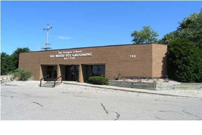
110 Chicago Dr
70-14-13-433-018
PART OF SE 1/4 COM 163326 FT N & S 84D 38M 34S W 78752 FT FROM SE SEC COR, TH S 05D 21M 26S E 13082 FT TO N'LY LI OF FRONTAGE
Medicalbuilding
Ottawa
CS
Michigan
AE The base floodplain where base flood elevations are provided. AE Zones are now used on new format FIRMs instead of A1-A30 Zones.
0.85 AC
2025
E Ottawa Cnty/Hudsonville
2026
West Michigan
021502
Grand Rapids-Wyoming-Kentwood, MI
4,460 SF
NEARBY LISTINGS FOR SALE OR LEASE
DEMOGRAPHICS near 110 Chicago Dr
1 mile
3 mile
5 mile
2025 Total Population
5,737
49,618
135,152
2030 Population
5,818
50,809
138,886
Pop Growth 2025-2030
+ 1.41%
+ 2.40%
+ 2.76%
Average Age
42
41
39
2025 Total Households
2,569
19,608
50,768
HH Growth 2025-2030
+ 1.63%
+ 2.54%
+ 2.85%
Median Household Inc
$75,917
$83,122
$83,376
Avg Household Size
2.20
2.50
2.60
2025 Avg HH Vehicles
2.00
2.00
2.00
Median Home Value
$248,617
$291,362
$284,164
Median Year Built
1973
1977
1979
Nearby Places
Map Layers
Map Styles
 Street
 Aerial
Layers
 Traffic
 Biking
Places
Listings with unknown addresses are not visible on the map
- Restaurants
- Banks
- Shops
- Fitness
- Groceries
PUBLIC TRANSPORTATION
COMMUTER RAIL
Drive
Walk
Distance
12 min
7.7 mi
AIRPORT
Gerald R Ford International
Drive
Walk
Distance
Gerald R Ford International
29 min
15.9 mi
SALE & LEASE HISTORY
LISTING DATE
SALE/LEASE

Jul 15, 2020
For Sale
Nearby Properties
Address
Land Use
TOTAL SIZE
Lot Size
Zoning
Address
Land Use
TOTAL SIZE
Lot Size
Zoning
79.40 AC
C-4
Address
Land Use
TOTAL SIZE
Lot Size
Zoning
899,034 SF
78.93 AC
B1
Address
Land Use
TOTAL SIZE
Lot Size
Zoning
12.64 AC
PUD
Address
Land Use
TOTAL SIZE
Lot Size
Zoning
307,361 SF
16.60 AC
R1-A
Address
Land Use
TOTAL SIZE
Lot Size
Zoning
268,440 SF
28.11 AC
HDR
Address
Land Use
TOTAL SIZE
Lot Size
Zoning
225,992 SF
14.40 AC
Address
Land Use
TOTAL SIZE
Lot Size
Zoning
269,021 SF
22.89 AC
HDR
Address
Land Use
TOTAL SIZE
Lot Size
Zoning
230,864 SF
59.58 AC
PUD2
Address
Land Use
TOTAL SIZE
Lot Size
Zoning
13.53 AC
R1-A
Address
Land Use
TOTAL SIZE
Lot Size
Zoning
191,331 SF
9.20 AC
PUD1
Address
Land Use
TOTAL SIZE
Lot Size
Zoning
173,288 SF
18.56 AC
PUD
Address
Land Use
TOTAL SIZE
Lot Size
Zoning
211,138 SF
30.58 AC
C-5
Address
Land Use
TOTAL SIZE
Lot Size
Zoning
293,441 SF
18 AC
I-1
Address
Land Use
TOTAL SIZE
Lot Size
Zoning
222,785 SF
25.16 AC
CS
Address
Land Use
TOTAL SIZE
Lot Size
Zoning
87,414 SF
14.72 AC
PUD
Address
Land Use
TOTAL SIZE
Lot Size
Zoning
155,304 SF
17.58 AC
R3-B
Address
Land Use
TOTAL SIZE
Lot Size
Zoning
246,880 SF
18.33 AC
I-2
Address
Land Use
TOTAL SIZE
Lot Size
Zoning
214,398 SF
18.66 AC
OS-2
Address
Land Use
TOTAL SIZE
Lot Size
Zoning
97,975 SF
12.88 AC
C-1
Address
Land Use
TOTAL SIZE
Lot Size
Zoning
14.69 AC
R3-B
Address
Land Use
TOTAL SIZE
Lot Size
Zoning
89,648 SF
3.17 AC
OS-2
Address
Land Use
TOTAL SIZE
Lot Size
Zoning
9.65 AC
R3-B
Address
Land Use
TOTAL SIZE
Lot Size
Zoning
143,800 SF
20.71 AC
I-1
Address
Land Use
TOTAL SIZE
Lot Size
Zoning
121,602 SF
45.20 AC
I-2
Address
Land Use
TOTAL SIZE
Lot Size
Zoning
92,778 SF
9.90 AC
PUD
Address
Land Use
TOTAL SIZE
Lot Size
Zoning
82,554 SF
5.56 AC
HDR
Address
Land Use
TOTAL SIZE
Lot Size
Zoning
9 AC
R3-A
Address
Land Use
TOTAL SIZE
Lot Size
Zoning
60,523 SF
6.48 AC
C-1
Address
Land Use
TOTAL SIZE
Lot Size
Zoning
136,766 SF
18.52 AC
B3
Address
Land Use
TOTAL SIZE
Lot Size
Zoning
164,700 SF
19.18 AC
C-5
The World's #1 Commercial Real Estate Marketplace
Connect with us
© 2026 CoStar Group
The information above has been obtained from sources believed reliable. While we do not doubt its accuracy we have not verified it and make no guarantee, warranty or representation about it. It is your responsibility to independently confirm its accuracy and completeness. Any projections, opinions, assumptions, or estimates used are for example only and do not represent the current or future performance of the property. The value of this transaction to you depends on tax and other factors which should be evaluated by your tax, financial, and legal advisors. You and your advisors should conduct a careful, independent investigation of the property to determine to your satisfaction the suitability of the property for your needs.