Property Record
110 Deats Rd, Dickinson, TX 77539
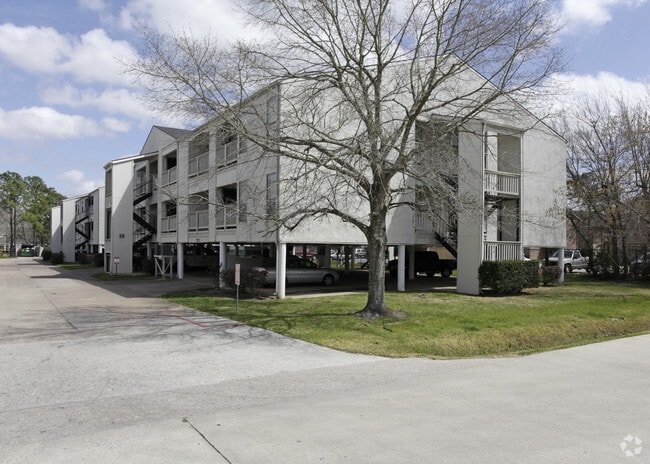

Property Detail
110 Deats Rd
Houston-Pasadena-The Woodlands, TX
ABST 19 PERRY & AUSTIN SUR PT OF LOTS 101 & 102 (0-3) DICKINSON ADDN
3015-0101-0000-003
Galveston
Apartment
Texas
AE The base floodplain where base flood elevations are provided. AE Zones are now used on new format FIRMs instead of A1-A30 Zones.
101
2024
4.70 AC
2025
North Galveston County
720900
Houston
84,936 SF
NEARBY LISTINGS FOR SALE OR LEASE
-
-
View all Dickinson listings for sale on LoopNet.com
DEMOGRAPHICS near 110 Deats Rd
1 mile
3 mile
5 mile
2024 Total Population
8,904
46,846
122,913
2029 Population
9,153
48,385
126,535
Pop Growth 2024-2029
+ 2.80%
+ 3.29%
+ 2.95%
Average Age
37
37
37
2024 Total Households
3,253
16,234
43,062
HH Growth 2024-2029
+ 2.89%
+ 3.14%
+ 2.89%
Median Household Inc
$94,241
$102,905
$105,341
Avg Household Size
2.70
2.80
2.80
2024 Avg HH Vehicles
2.00
2.00
2.00
Median Home Value
$280,749
$296,608
$316,075
Median Year Built
1989
2002
2000
Nearby Places
Map Layers
Map Styles
 Street
 Aerial
Transit
 Traffic
 Biking
Places
Listings with unknown addresses are not visible on the map
- Restaurants
- Banks
- Shops
- Fitness
- Groceries
PUBLIC TRANSPORTATION
AIRPORT
William P Hobby
Drive
Walk
Distance
William P Hobby
31 min
19.8 mi
Nearby Properties
Address
Land Use
TOTAL SIZE
Lot Size
Zoning
Address
Land Use
TOTAL SIZE
Lot Size
Zoning
417,305 SF
32.01 AC
Address
Land Use
TOTAL SIZE
Lot Size
Zoning
450,000 SF
27.82 AC
Address
Land Use
TOTAL SIZE
Lot Size
Zoning
355,987 SF
46.99 AC
Address
Land Use
TOTAL SIZE
Lot Size
Zoning
366,500 SF
21.88 AC
Address
Land Use
TOTAL SIZE
Lot Size
Zoning
165,000 SF
50.03 AC
Address
Land Use
TOTAL SIZE
Lot Size
Zoning
17,784 SF
37.39 AC
Address
Land Use
TOTAL SIZE
Lot Size
Zoning
175,000 SF
29.99 AC
Address
Land Use
TOTAL SIZE
Lot Size
Zoning
200,240 SF
14.73 AC
Address
Land Use
TOTAL SIZE
Lot Size
Zoning
12.95 AC
Address
Land Use
TOTAL SIZE
Lot Size
Zoning
226,300 SF
12.11 AC
Address
Land Use
TOTAL SIZE
Lot Size
Zoning
260,343 SF
14.46 AC
Address
Land Use
TOTAL SIZE
Lot Size
Zoning
219,355 SF
10.24 AC
Address
Land Use
TOTAL SIZE
Lot Size
Zoning
70,660 SF
27.08 AC
Address
Land Use
TOTAL SIZE
Lot Size
Zoning
113,400 SF
21.05 AC
Address
Land Use
TOTAL SIZE
Lot Size
Zoning
218,231 SF
22.45 AC
Address
Land Use
TOTAL SIZE
Lot Size
Zoning
156,188 SF
7.07 AC
Address
Land Use
TOTAL SIZE
Lot Size
Zoning
92,716 SF
11.35 AC
Address
Land Use
TOTAL SIZE
Lot Size
Zoning
176,681 SF
13.43 AC
Address
Land Use
TOTAL SIZE
Lot Size
Zoning
90,273 SF
8.76 AC
Address
Land Use
TOTAL SIZE
Lot Size
Zoning
129,600 SF
25.69 AC
Address
Land Use
TOTAL SIZE
Lot Size
Zoning
102,938 SF
9.22 AC
Address
Land Use
TOTAL SIZE
Lot Size
Zoning
78,092 SF
10.65 AC
Address
Land Use
TOTAL SIZE
Lot Size
Zoning
47,656 SF
Address
Land Use
TOTAL SIZE
Lot Size
Zoning
60,400 SF
17.89 AC
Address
Land Use
TOTAL SIZE
Lot Size
Zoning
87,528 SF
7.89 AC
Address
Land Use
TOTAL SIZE
Lot Size
Zoning
177,387 SF
13.49 AC
Address
Land Use
TOTAL SIZE
Lot Size
Zoning
218,231 SF
12.65 AC
Address
Land Use
TOTAL SIZE
Lot Size
Zoning
81,548 SF
4.75 AC
Address
Land Use
TOTAL SIZE
Lot Size
Zoning
128,802 SF
5.62 AC
Address
Land Use
TOTAL SIZE
Lot Size
Zoning
111,650 SF
9.24 AC
The World's #1 Commercial Real Estate Marketplace
Connect with us
© 2026 CoStar Group
The information above has been obtained from sources believed reliable. While we do not doubt its accuracy we have not verified it and make no guarantee, warranty or representation about it. It is your responsibility to independently confirm its accuracy and completeness. Any projections, opinions, assumptions, or estimates used are for example only and do not represent the current or future performance of the property. The value of this transaction to you depends on tax and other factors which should be evaluated by your tax, financial, and legal advisors. You and your advisors should conduct a careful, independent investigation of the property to determine to your satisfaction the suitability of the property for your needs.