Property Record
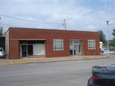
110 E 3Rd St, Cedar Falls, IA 50613

Property Detail
110 E 3Rd St
Waterloo-Cedar Falls, IA
ORIGINAL PLAT CEDAR FALLS E 56 FT S 44 FT LOT 5 BLK 5
8914-12-252-009
Black Hawk
Restaurantbuilding
Iowa
B and X Area of moderate flood hazard, usually the area between the limits of the 100-year and 500-year floods.
5
2024
0.06 AC
2025
Downtown Cedar Falls
002200
Other Market Areas
2,464 SF
NEARBY LISTINGS FOR SALE OR LEASE
DEMOGRAPHICS near 110 E 3Rd St
1 mile
3 mile
5 mile
2024 Total Population
5,450
36,825
54,336
2029 Population
5,516
37,333
55,098
Pop Growth 2024-2029
+ 1.21%
+ 1.38%
+ 1.40%
Average Age
37
37
38
2024 Total Households
2,375
14,654
22,230
HH Growth 2024-2029
+ 1.26%
+ 1.43%
+ 1.42%
Median Household Inc
$67,467
$67,979
$66,536
Avg Household Size
2.20
2.30
2.30
2024 Avg HH Vehicles
2.00
2.00
2.00
Median Home Value
$187,228
$251,569
$223,704
Median Year Built
1950
1972
1972
Nearby Places
Map Layers
Map Styles
 Street
 Aerial
Transit
 Traffic
 Biking
Places
Listings with unknown addresses are not visible on the map
- Restaurants
- Banks
- Shops
- Fitness
- Groceries
Nearby Properties
Address
Land Use
TOTAL SIZE
Lot Size
Zoning
Address
Land Use
TOTAL SIZE
Lot Size
Zoning
1,536 SF
50.01 AC
Address
Land Use
TOTAL SIZE
Lot Size
Zoning
9,719 SF
42.81 AC
Address
Land Use
TOTAL SIZE
Lot Size
Zoning
1,355.76 AC
Address
Land Use
TOTAL SIZE
Lot Size
Zoning
16,044 SF
Address
Land Use
TOTAL SIZE
Lot Size
Zoning
124,305 SF
4.74 AC
Address
Land Use
TOTAL SIZE
Lot Size
Zoning
123,653 SF
8.66 AC
Address
Land Use
TOTAL SIZE
Lot Size
Zoning
91,112 SF
2.01 AC
Address
Land Use
TOTAL SIZE
Lot Size
Zoning
13,584 SF
Address
Land Use
TOTAL SIZE
Lot Size
Zoning
1,800 SF
14.60 AC
Address
Land Use
TOTAL SIZE
Lot Size
Zoning
18,330 SF
9.56 AC
Address
Land Use
TOTAL SIZE
Lot Size
Zoning
2,574 SF
15 AC
Address
Land Use
TOTAL SIZE
Lot Size
Zoning
173,435 SF
20 AC
Address
Land Use
TOTAL SIZE
Lot Size
Zoning
49,360 SF
0.80 AC
Address
Land Use
TOTAL SIZE
Lot Size
Zoning
55,078 SF
1.39 AC
Address
Land Use
TOTAL SIZE
Lot Size
Zoning
73,386 SF
2.02 AC
Address
Land Use
TOTAL SIZE
Lot Size
Zoning
11,828 SF
6.58 AC
Address
Land Use
TOTAL SIZE
Lot Size
Zoning
42,844 SF
0.65 AC
Address
Land Use
TOTAL SIZE
Lot Size
Zoning
106,032 SF
8.22 AC
Address
Land Use
TOTAL SIZE
Lot Size
Zoning
2,466 SF
6.53 AC
Address
Land Use
TOTAL SIZE
Lot Size
Zoning
34,707 SF
4.19 AC
Address
Land Use
TOTAL SIZE
Lot Size
Zoning
80,352 SF
1.88 AC
Address
Land Use
TOTAL SIZE
Lot Size
Zoning
105,224 SF
4.59 AC
Address
Land Use
TOTAL SIZE
Lot Size
Zoning
98,711 SF
7.91 AC
Address
Land Use
TOTAL SIZE
Lot Size
Zoning
13,305 SF
2.17 AC
Address
Land Use
TOTAL SIZE
Lot Size
Zoning
71,997 SF
8.18 AC
Address
Land Use
TOTAL SIZE
Lot Size
Zoning
14,352 SF
4.12 AC
Address
Land Use
TOTAL SIZE
Lot Size
Zoning
88,064 SF
6.86 AC
Address
Land Use
TOTAL SIZE
Lot Size
Zoning
65,473 SF
6.04 AC
Address
Land Use
TOTAL SIZE
Lot Size
Zoning
28.30 AC
The World's #1 Commercial Real Estate Marketplace
Connect with us
© 2026 CoStar Group
The information above has been obtained from sources believed reliable. While we do not doubt its accuracy we have not verified it and make no guarantee, warranty or representation about it. It is your responsibility to independently confirm its accuracy and completeness. Any projections, opinions, assumptions, or estimates used are for example only and do not represent the current or future performance of the property. The value of this transaction to you depends on tax and other factors which should be evaluated by your tax, financial, and legal advisors. You and your advisors should conduct a careful, independent investigation of the property to determine to your satisfaction the suitability of the property for your needs.