Property Record
110 E Brainard St, Harvard, IL 60033
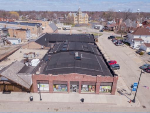

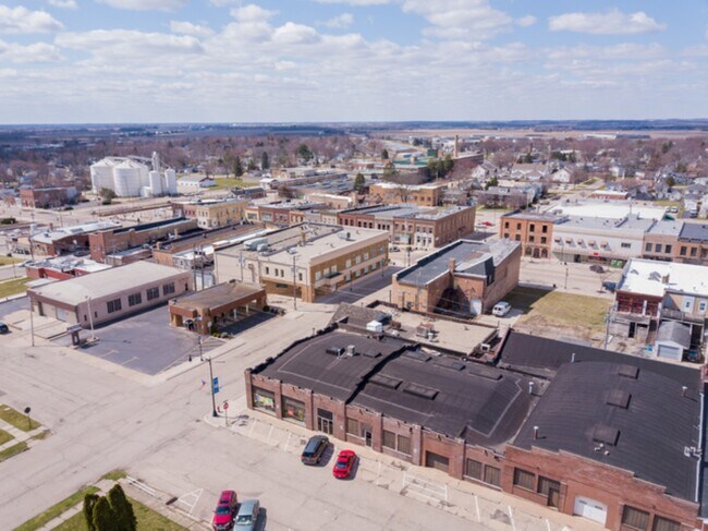
Property Detail
110 E Brainard St
Chicago-Naperville-Elgin, IL-IN
SOUTH2 OF LOT14
01-35-411-015
McHenry
Commercialnec
Illinois
B and X Area of moderate flood hazard, usually the area between the limits of the 100-year and 500-year floods.
12,13
2024
0.26 AC
2024
Far Northwest
870302
Chicago
NEARBY LISTINGS FOR SALE OR LEASE
-
-
View all Harvard listings for sale on LoopNet.com
DEMOGRAPHICS near 110 E Brainard St
1 mile
3 mile
5 mile
2025 Total Population
8,613
11,553
13,051
2030 Population
8,793
11,790
13,288
Pop Growth 2025-2030
+ 2.09%
+ 2.05%
+ 1.82%
Average Age
37
37
38
2025 Total Households
2,897
3,954
4,541
HH Growth 2025-2030
+ 2.17%
+ 2.07%
+ 1.81%
Median Household Inc
$69,950
$71,863
$72,795
Avg Household Size
2.90
2.90
2.80
2025 Avg HH Vehicles
2.00
2.00
2.00
Median Home Value
$169,255
$181,722
$196,064
Median Year Built
1978
1982
1981
Nearby Places
Map Layers
Map Styles
 Street
 Aerial
Transit
 Traffic
 Biking
Places
Listings with unknown addresses are not visible on the map
- Restaurants
- Banks
- Shops
- Fitness
- Groceries
PUBLIC TRANSPORTATION
TRANSIT/SUBWAY
Harvard Station (Union Pacific Northwest Line - Northeast Illinois Regional Commuter Railroad (Metra))
Drive
Walk
Distance
Harvard Station (Union Pacific Northwest Line - Northeast Illinois Regional Commuter Railroad (Metra))
1 min
6 min
0.3 mi
COMMUTER RAIL
Harvard Station (Union Pacific Northwest Line - Northeast Illinois Regional Commuter Railroad (Metra))
Drive
Walk
Distance
Harvard Station (Union Pacific Northwest Line - Northeast Illinois Regional Commuter Railroad (Metra))
1 min
6 min
0.3 mi
AIRPORT
Chicago/Rockford International
Drive
Walk
Distance
Chicago/Rockford International
59 min
41.0 mi
Freight Ports
Port Milwaukee
Drive
Walk
Distance
Port Milwaukee
82 min
63.8 mi
SALE & LEASE HISTORY
LISTING DATE
SALE/LEASE

Sep 30, 2016
For Lease
Apr 12, 2018
For Lease
Apr 01, 2021
For Sale
Nearby Properties
Address
Land Use
TOTAL SIZE
Lot Size
Zoning
Address
Land Use
TOTAL SIZE
Lot Size
Zoning
23.89 AC
Address
Land Use
TOTAL SIZE
Lot Size
Zoning
290.30 AC
Address
Land Use
TOTAL SIZE
Lot Size
Zoning
150,352 SF
16.65 AC
Address
Land Use
TOTAL SIZE
Lot Size
Zoning
457,340 SF
19.04 AC
Address
Land Use
TOTAL SIZE
Lot Size
Zoning
8.38 AC
Address
Land Use
TOTAL SIZE
Lot Size
Zoning
4.34 AC
Address
Land Use
TOTAL SIZE
Lot Size
Zoning
6.51 AC
Address
Land Use
TOTAL SIZE
Lot Size
Zoning
346,000 SF
11.50 AC
Address
Land Use
TOTAL SIZE
Lot Size
Zoning
17.16 AC
Address
Land Use
TOTAL SIZE
Lot Size
Zoning
5.89 AC
Address
Land Use
TOTAL SIZE
Lot Size
Zoning
209,100 SF
8.04 AC
Address
Land Use
TOTAL SIZE
Lot Size
Zoning
292,500 SF
17.66 AC
Address
Land Use
TOTAL SIZE
Lot Size
Zoning
Address
Land Use
TOTAL SIZE
Lot Size
Zoning
3.44 AC
Address
Land Use
TOTAL SIZE
Lot Size
Zoning
25,475 SF
2.69 AC
Address
Land Use
TOTAL SIZE
Lot Size
Zoning
3.16 AC
Address
Land Use
TOTAL SIZE
Lot Size
Zoning
3.74 AC
Address
Land Use
TOTAL SIZE
Lot Size
Zoning
7,232 SF
2.15 AC
Address
Land Use
TOTAL SIZE
Lot Size
Zoning
Address
Land Use
TOTAL SIZE
Lot Size
Zoning
45,771 SF
5.90 AC
Address
Land Use
TOTAL SIZE
Lot Size
Zoning
52,107 SF
5.03 AC
Address
Land Use
TOTAL SIZE
Lot Size
Zoning
2.23 AC
Address
Land Use
TOTAL SIZE
Lot Size
Zoning
1.31 AC
Address
Land Use
TOTAL SIZE
Lot Size
Zoning
13,619 SF
1.66 AC
Address
Land Use
TOTAL SIZE
Lot Size
Zoning
15,750 SF
1.60 AC
Address
Land Use
TOTAL SIZE
Lot Size
Zoning
29,076 SF
1.75 AC
Address
Land Use
TOTAL SIZE
Lot Size
Zoning
0.98 AC
Address
Land Use
TOTAL SIZE
Lot Size
Zoning
0.49 AC
Address
Land Use
TOTAL SIZE
Lot Size
Zoning
20,434 SF
0.65 AC
Address
Land Use
TOTAL SIZE
Lot Size
Zoning
The World's #1 Commercial Real Estate Marketplace
Connect with us
© 2026 CoStar Group
The information above has been obtained from sources believed reliable. While we do not doubt its accuracy we have not verified it and make no guarantee, warranty or representation about it. It is your responsibility to independently confirm its accuracy and completeness. Any projections, opinions, assumptions, or estimates used are for example only and do not represent the current or future performance of the property. The value of this transaction to you depends on tax and other factors which should be evaluated by your tax, financial, and legal advisors. You and your advisors should conduct a careful, independent investigation of the property to determine to your satisfaction the suitability of the property for your needs.