Property Record
110 E Canal St, Troy, OH 45373
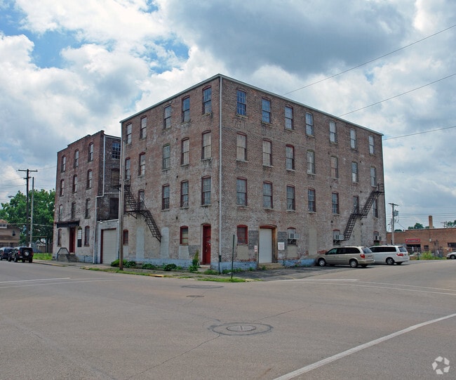

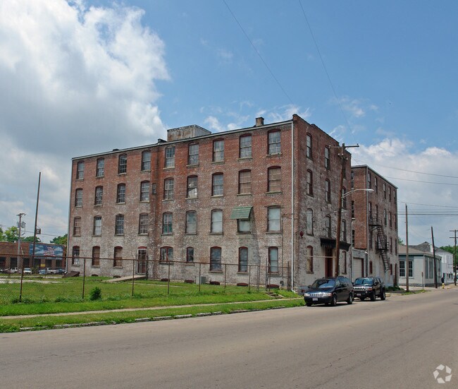
Property Detail
110 E Canal St
Dayton, OH
IL 11525
D08251017
MIAMI
Municipalproperty
Ohio
B and X Area of moderate flood hazard, usually the area between the limits of the 100-year and 500-year floods.
11525
2025
1.14 AC
2025
North Dayton
365200
Cincinnati/Dayton
16,290 SF
NEARBY LISTINGS FOR SALE OR LEASE
-
-
View all Troy listings for sale on LoopNet.com
DEMOGRAPHICS near 110 E Canal St
1 mile
3 mile
5 mile
2025 Total Population
9,417
31,435
42,091
2030 Population
9,675
32,342
43,357
Pop Growth 2025-2030
+ 2.74%
+ 2.89%
+ 3.01%
Average Age
39
41
41
2025 Total Households
3,996
13,137
17,295
HH Growth 2025-2030
+ 2.83%
+ 2.91%
+ 3.00%
Median Household Inc
$62,479
$74,605
$79,860
Avg Household Size
2.30
2.30
2.40
2025 Avg HH Vehicles
2.00
2.00
2.00
Median Home Value
$178,858
$261,961
$278,408
Median Year Built
1948
1973
1975
Nearby Places
Map Layers
Map Styles
 Street
 Aerial
Transit
 Traffic
 Biking
Places
Listings with unknown addresses are not visible on the map
- Restaurants
- Banks
- Shops
- Fitness
- Groceries
PUBLIC TRANSPORTATION
AIRPORT
James M Cox Dayton International
Drive
Walk
Distance
James M Cox Dayton International
23 min
14.2 mi
Nearby Properties
Address
Land Use
TOTAL SIZE
Lot Size
Zoning
Address
Land Use
TOTAL SIZE
Lot Size
Zoning
150,128 SF
11.71 AC
Address
Land Use
TOTAL SIZE
Lot Size
Zoning
7,200 SF
25.38 AC
Address
Land Use
TOTAL SIZE
Lot Size
Zoning
8.43 AC
Address
Land Use
TOTAL SIZE
Lot Size
Zoning
1,310 SF
12.31 AC
Address
Land Use
TOTAL SIZE
Lot Size
Zoning
8.94 AC
Address
Land Use
TOTAL SIZE
Lot Size
Zoning
75,861 SF
8 AC
Address
Land Use
TOTAL SIZE
Lot Size
Zoning
50,400 SF
54.09 AC
Address
Land Use
TOTAL SIZE
Lot Size
Zoning
49,496 SF
10.15 AC
Address
Land Use
TOTAL SIZE
Lot Size
Zoning
536,448 SF
66.57 AC
Address
Land Use
TOTAL SIZE
Lot Size
Zoning
548,745 SF
56.35 AC
Address
Land Use
TOTAL SIZE
Lot Size
Zoning
68,679 SF
1.72 AC
Address
Land Use
TOTAL SIZE
Lot Size
Zoning
94,555 SF
13.32 AC
Address
Land Use
TOTAL SIZE
Lot Size
Zoning
48,363 SF
14.35 AC
Address
Land Use
TOTAL SIZE
Lot Size
Zoning
85.35 AC
Address
Land Use
TOTAL SIZE
Lot Size
Zoning
12.05 AC
Address
Land Use
TOTAL SIZE
Lot Size
Zoning
54,671 SF
15.57 AC
Address
Land Use
TOTAL SIZE
Lot Size
Zoning
85.35 AC
Address
Land Use
TOTAL SIZE
Lot Size
Zoning
57,440 SF
1.81 AC
Address
Land Use
TOTAL SIZE
Lot Size
Zoning
Address
Land Use
TOTAL SIZE
Lot Size
Zoning
3,944 SF
12.18 AC
Address
Land Use
TOTAL SIZE
Lot Size
Zoning
Address
Land Use
TOTAL SIZE
Lot Size
Zoning
5,564 SF
21.42 AC
Address
Land Use
TOTAL SIZE
Lot Size
Zoning
13.64 AC
Address
Land Use
TOTAL SIZE
Lot Size
Zoning
223,905 SF
17.75 AC
Address
Land Use
TOTAL SIZE
Lot Size
Zoning
132,772 SF
15.34 AC
Address
Land Use
TOTAL SIZE
Lot Size
Zoning
Address
Land Use
TOTAL SIZE
Lot Size
Zoning
45,900 SF
1.75 AC
Address
Land Use
TOTAL SIZE
Lot Size
Zoning
8.82 AC
Address
Land Use
TOTAL SIZE
Lot Size
Zoning
211,925 SF
13 AC
Address
Land Use
TOTAL SIZE
Lot Size
Zoning
45,271 SF
11.07 AC
The World's #1 Commercial Real Estate Marketplace
Connect with us
© 2026 CoStar Group
The information above has been obtained from sources believed reliable. While we do not doubt its accuracy we have not verified it and make no guarantee, warranty or representation about it. It is your responsibility to independently confirm its accuracy and completeness. Any projections, opinions, assumptions, or estimates used are for example only and do not represent the current or future performance of the property. The value of this transaction to you depends on tax and other factors which should be evaluated by your tax, financial, and legal advisors. You and your advisors should conduct a careful, independent investigation of the property to determine to your satisfaction the suitability of the property for your needs.