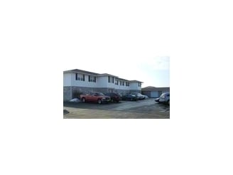
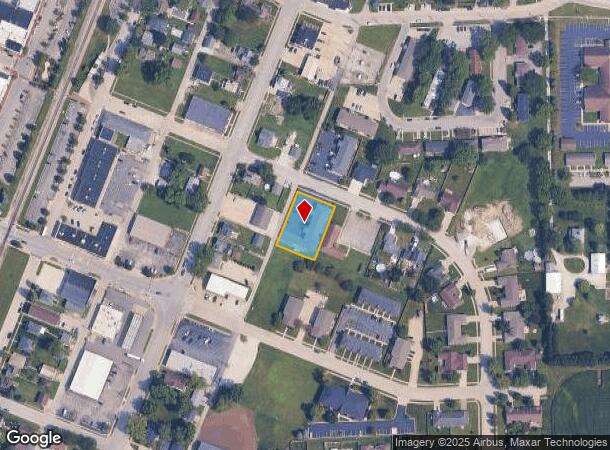
Property Record
110 E First St, Manteno, IL 60950
NEARBY LISTINGS FOR SALE OR LEASE
-
-
View all Manteno listings for sale on LoopNet.com
Property Detail
110 E First St
Kankakee, IL
Tamblyn Acres Sub
03-02-22-125-007
TAMBLYN ACRES SUBD LOT 7 22-32-12E
Apartmenthouse5plusunits
Kankakee
X
Illinois
17091C0202E
7
2024
0.47 AC
2024
Other Market Areas
010203
DEMOGRAPHICS near 110 E First St
1 mile
3 mile
5 mile
2024 Total Population
5,884
10,765
15,302
2029 Population
5,713
10,535
15,042
Pop Growth 2024-2029
(2.91%)
(2.14%)
(1.70%)
Average Age
44
43
41
2024 Total Households
2,579
4,312
5,944
HH Growth 2024-2029
(2.91%)
(2.16%)
(1.75%)
Median Household Inc
$79,211
$87,093
$83,566
Avg Household Size
2.20
2.40
2.50
2024 Avg HH Vehicles
2.00
2.00
2.00
Median Home Value
$215,268
$231,483
$222,196
Median Year Built
1989
1993
1994
Nearby Places
Map Layers
Map Styles
 Street
 Aerial
Transit
 Traffic
 Biking
Places
Listings with unknown addresses are not visible on the map
- Restaurants
- Banks
- Shops
- Fitness
- Groceries
PUBLIC TRANSPORTATION
COMMUTER RAIL
Kankakee (City of New Orleans - Amtrak, Illini - Amtrak, Saluki - Amtrak)
Drive
Walk
Distance
Kankakee (City of New Orleans - Amtrak, Illini - Amtrak, Saluki - Amtrak)
16 min
10.0 mi
Freight Ports
Port Milwaukee
Drive
Walk
Distance
Port Milwaukee
165 min
134.7 mi
Nearby Properties
Address
Land Use
TOTAL SIZE
Lot Size
Zoning
Address
Land Use
TOTAL SIZE
Lot Size
Zoning
112.85 AC
Address
Land Use
TOTAL SIZE
Lot Size
Zoning
50.11 AC
I2
Address
Land Use
TOTAL SIZE
Lot Size
Zoning
68.70 AC
I2
Address
Land Use
TOTAL SIZE
Lot Size
Zoning
75 AC
I2
Address
Land Use
TOTAL SIZE
Lot Size
Zoning
Address
Land Use
TOTAL SIZE
Lot Size
Zoning
11.58 AC
I2
Address
Land Use
TOTAL SIZE
Lot Size
Zoning
Address
Land Use
TOTAL SIZE
Lot Size
Zoning
17.30 AC
I2
Address
Land Use
TOTAL SIZE
Lot Size
Zoning
8 AC
I2
Address
Land Use
TOTAL SIZE
Lot Size
Zoning
12 AC
I2
Address
Land Use
TOTAL SIZE
Lot Size
Zoning
13 AC
I2
Address
Land Use
TOTAL SIZE
Lot Size
Zoning
43.74 AC
A1
Address
Land Use
TOTAL SIZE
Lot Size
Zoning
0.60 AC
Address
Land Use
TOTAL SIZE
Lot Size
Zoning
3.50 AC
I2
Address
Land Use
TOTAL SIZE
Lot Size
Zoning
9.11 AC
I2
Address
Land Use
TOTAL SIZE
Lot Size
Zoning
10.26 AC
I2
Address
Land Use
TOTAL SIZE
Lot Size
Zoning
7.32 AC
Address
Land Use
TOTAL SIZE
Lot Size
Zoning
Address
Land Use
TOTAL SIZE
Lot Size
Zoning
12.40 AC
I2
Address
Land Use
TOTAL SIZE
Lot Size
Zoning
Address
Land Use
TOTAL SIZE
Lot Size
Zoning
2.55 AC
Address
Land Use
TOTAL SIZE
Lot Size
Zoning
2.21 AC
Address
Land Use
TOTAL SIZE
Lot Size
Zoning
4.67 AC
Address
Land Use
TOTAL SIZE
Lot Size
Zoning
7.12 AC
I2
Address
Land Use
TOTAL SIZE
Lot Size
Zoning
29.59 AC
Address
Land Use
TOTAL SIZE
Lot Size
Zoning
11.63 AC
I2
Address
Land Use
TOTAL SIZE
Lot Size
Zoning
3.65 AC
I2
Address
Land Use
TOTAL SIZE
Lot Size
Zoning
5.65 AC
I1
Address
Land Use
TOTAL SIZE
Lot Size
Zoning
6.37 AC
The World's #1 Commercial Real Estate Marketplace
Connect with us
© 2026 CoStar Group
The information above has been obtained from sources believed reliable. While we do not doubt its accuracy we have not verified it and make no guarantee, warranty or representation about it. It is your responsibility to independently confirm its accuracy and completeness. Any projections, opinions, assumptions, or estimates used are for example only and do not represent the current or future performance of the property. The value of this transaction to you depends on tax and other factors which should be evaluated by your tax, financial, and legal advisors. You and your advisors should conduct a careful, independent investigation of the property to determine to your satisfaction the suitability of the property for your needs.