Property Record
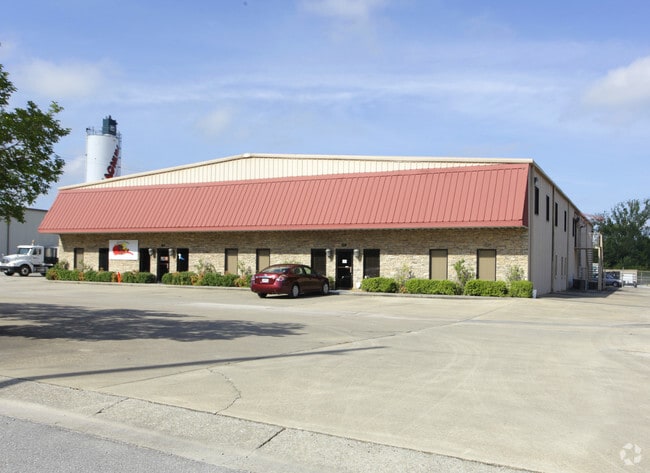
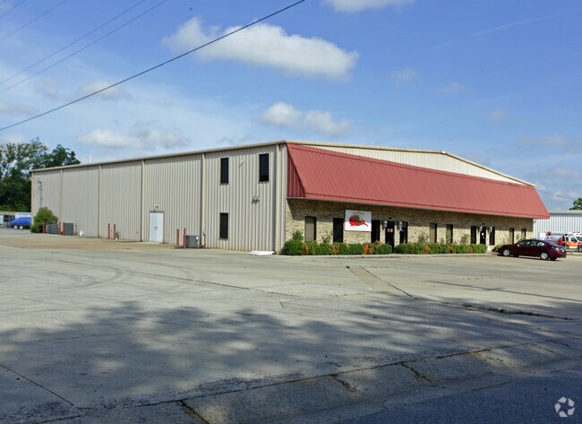
110 Longview Cir, Alabaster, AL 35007


Property Detail
110 Longview Cir
22-4-20-0-000-004-002
COM NW COR SEC E TO E ROW RR SLY263.94 TO POB; CONT 3.92 SW50.07 SE181.6 NE464.06 NW143.71 SW427.95 TO POB.
Warehouse
Shelby
B and X Area of moderate flood hazard, usually the area between the limits of the 100-year and 500-year floods.
Alabama
2025
2 AC
2025
I-65 Corr/S Shelby County
030614
Birmingham
18,000 SF
Birmingham, AL
NEARBY LISTINGS FOR SALE OR LEASE
DEMOGRAPHICS near 110 Longview Cir
1 mile
3 mile
5 mile
2025 Total Population
534
8,942
44,914
2030 Population
561
9,402
46,816
Pop Growth 2025-2030
+ 5.06%
+ 5.14%
+ 4.23%
Average Age
39
39
40
2025 Total Households
191
3,249
16,476
HH Growth 2025-2030
+ 4.71%
+ 5.17%
+ 4.26%
Median Household Inc
$97,221
$90,163
$84,290
Avg Household Size
2.80
2.70
2.70
2025 Avg HH Vehicles
2.00
2.00
2.00
Median Home Value
$283,333
$266,137
$265,304
Median Year Built
1997
2003
1999
Nearby Places
Map Layers
Map Styles
 Street
 Aerial
Layers
 Traffic
 Biking
Places
Listings with unknown addresses are not visible on the map
- Restaurants
- Banks
- Shops
- Fitness
- Groceries
PUBLIC TRANSPORTATION
AIRPORT
Birmingham-Shuttlesworth International
Drive
Walk
Distance
Birmingham-Shuttlesworth International
40 min
30.4 mi
Freight Ports
Port of Mobile
Drive
Walk
Distance
Port of Mobile
254 min
231.5 mi
SALE & LEASE HISTORY
LISTING DATE
SALE/LEASE

Feb 11, 2021
For Sale
Nearby Properties
Address
Land Use
TOTAL SIZE
Lot Size
Zoning
Address
Land Use
TOTAL SIZE
Lot Size
Zoning
416,160 SF
58.85 AC
Address
Land Use
TOTAL SIZE
Lot Size
Zoning
9,444 SF
21.79 AC
Address
Land Use
TOTAL SIZE
Lot Size
Zoning
573,600 SF
19.96 AC
Address
Land Use
TOTAL SIZE
Lot Size
Zoning
500,500 SF
17.45 AC
Address
Land Use
TOTAL SIZE
Lot Size
Zoning
220,000 SF
21.76 AC
Address
Land Use
TOTAL SIZE
Lot Size
Zoning
249,500 SF
16.15 AC
Address
Land Use
TOTAL SIZE
Lot Size
Zoning
219,975 SF
14.90 AC
Address
Land Use
TOTAL SIZE
Lot Size
Zoning
14,625 SF
118 AC
Address
Land Use
TOTAL SIZE
Lot Size
Zoning
62,398 SF
11.51 AC
Address
Land Use
TOTAL SIZE
Lot Size
Zoning
38,551 SF
17.81 AC
Address
Land Use
TOTAL SIZE
Lot Size
Zoning
126,897 SF
9.43 AC
Address
Land Use
TOTAL SIZE
Lot Size
Zoning
129,305 SF
50 AC
Address
Land Use
TOTAL SIZE
Lot Size
Zoning
6,234 SF
33 AC
Address
Land Use
TOTAL SIZE
Lot Size
Zoning
8,416 SF
16.12 AC
Address
Land Use
TOTAL SIZE
Lot Size
Zoning
30,158 SF
8.35 AC
Address
Land Use
TOTAL SIZE
Lot Size
Zoning
9,728 SF
11.01 AC
Address
Land Use
TOTAL SIZE
Lot Size
Zoning
137,068 SF
9.08 AC
Address
Land Use
TOTAL SIZE
Lot Size
Zoning
208,000 SF
11.91 AC
Address
Land Use
TOTAL SIZE
Lot Size
Zoning
154,440 SF
12.03 AC
Address
Land Use
TOTAL SIZE
Lot Size
Zoning
121,500 SF
13.80 AC
Address
Land Use
TOTAL SIZE
Lot Size
Zoning
43,903 SF
10.21 AC
Address
Land Use
TOTAL SIZE
Lot Size
Zoning
50,558 SF
22.76 AC
Address
Land Use
TOTAL SIZE
Lot Size
Zoning
5,000 SF
43 AC
Address
Land Use
TOTAL SIZE
Lot Size
Zoning
139,170 SF
15.30 AC
Address
Land Use
TOTAL SIZE
Lot Size
Zoning
21,000 SF
5.44 AC
Address
Land Use
TOTAL SIZE
Lot Size
Zoning
672 SF
7.33 AC
Address
Land Use
TOTAL SIZE
Lot Size
Zoning
241.36 AC
Address
Land Use
TOTAL SIZE
Lot Size
Zoning
28,090 SF
4.02 AC
Address
Land Use
TOTAL SIZE
Lot Size
Zoning
46,444 SF
2.70 AC
Address
Land Use
TOTAL SIZE
Lot Size
Zoning
14,163 SF
12.78 AC
The World's #1 Commercial Real Estate Marketplace
Connect with us
© 2026 CoStar Group
The information above has been obtained from sources believed reliable. While we do not doubt its accuracy we have not verified it and make no guarantee, warranty or representation about it. It is your responsibility to independently confirm its accuracy and completeness. Any projections, opinions, assumptions, or estimates used are for example only and do not represent the current or future performance of the property. The value of this transaction to you depends on tax and other factors which should be evaluated by your tax, financial, and legal advisors. You and your advisors should conduct a careful, independent investigation of the property to determine to your satisfaction the suitability of the property for your needs.