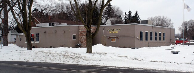
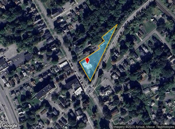
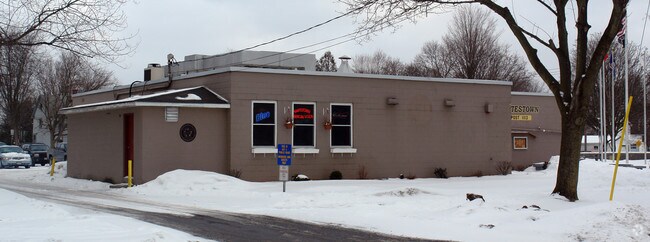
Property Record
110 Main St, Whitesboro, NY 13492
NEARBY LISTINGS FOR SALE OR LEASE
-
-
View all Whitesboro listings for sale on LoopNet.com
Property Detail
110 Main St
305-010-0003-020-000-0000
Oneida
Charitableorganization
New York
AE
20.000
36065C0731F
3.14 AC
2025
Outlying Oneida County
2024
Utica/Rome
023200
Utica-Rome, NY
4,308 SF
DEMOGRAPHICS near 110 Main St
1 Mile
3 Mile
5 Mile
2024 Total Population
5,920
38,531
99,460
2029 Population
5,811
37,921
97,457
Pop Growth 2024-2029
(1.84%)
(1.58%)
(2.01%)
Average Age
41
40
40
2024 Total Households
2,787
15,345
40,485
HH Growth 2024-2029
(2.05%)
(1.74%)
(2.05%)
Median Household Inc
$62,641
$52,317
$53,877
Avg Household Size
2.10
2.20
2.30
2024 Avg HH Vehicles
2.00
2.00
1.00
Median Home Value
$150,821
$151,142
$153,041
Median Year Built
1952
1951
1952
Nearby Places
- Restaurants
- Banks
- Shops
- Fitness
- Groceries
PUBLIC TRANSPORTATION
COMMUTER RAIL
DRIVE
WALK
Distance
8 min
4.3 mi
DRIVE
WALK
Distance
8 min
4.4 mi
Nearby Properties
Address
Land Use
TOTAL SIZE
Lot Size
Zoning
Address
Land Use
TOTAL SIZE
Lot Size
Zoning
446,163 SF
24.07 AC
05 - COMME
Address
Land Use
TOTAL SIZE
Lot Size
Zoning
74,414 SF
45.44 AC
01
Address
Land Use
TOTAL SIZE
Lot Size
Zoning
279,786 SF
121 AC
Address
Land Use
TOTAL SIZE
Lot Size
Zoning
236,597 SF
2.10 AC
Address
Land Use
TOTAL SIZE
Lot Size
Zoning
109,000 SF
13.56 AC
01 - NOT Z
Address
Land Use
TOTAL SIZE
Lot Size
Zoning
58,650 SF
1,024.59 AC
05 - COMME
Address
Land Use
TOTAL SIZE
Lot Size
Zoning
50,000 SF
4.20 AC
05 - COMME
Address
Land Use
TOTAL SIZE
Lot Size
Zoning
208,247 SF
20.43 AC
Address
Land Use
TOTAL SIZE
Lot Size
Zoning
131,534 SF
16 AC
05 - COMME
Address
Land Use
TOTAL SIZE
Lot Size
Zoning
180,605 SF
40.60 AC
Address
Land Use
TOTAL SIZE
Lot Size
Zoning
25,860 SF
18.45 AC
05 - COMME
Address
Land Use
TOTAL SIZE
Lot Size
Zoning
55,172 SF
81.24 AC
Address
Land Use
TOTAL SIZE
Lot Size
Zoning
129,456 SF
15.02 AC
01 - NOT Z
Address
Land Use
TOTAL SIZE
Lot Size
Zoning
55,916 SF
4.50 AC
Address
Land Use
TOTAL SIZE
Lot Size
Zoning
98,900 SF
28.20 AC
05 - COMME
Address
Land Use
TOTAL SIZE
Lot Size
Zoning
137,933 SF
15.13 AC
Address
Land Use
TOTAL SIZE
Lot Size
Zoning
94,050 SF
22.58 AC
05 - COMME
Address
Land Use
TOTAL SIZE
Lot Size
Zoning
77,584 SF
8 AC
Address
Land Use
TOTAL SIZE
Lot Size
Zoning
8.31 AC
05
Address
Land Use
TOTAL SIZE
Lot Size
Zoning
118,048 SF
32.59 AC
05 - COMME
Address
Land Use
TOTAL SIZE
Lot Size
Zoning
128,500 SF
19.10 AC
05 - COMME
Address
Land Use
TOTAL SIZE
Lot Size
Zoning
47,732 SF
0.86 AC
DS
Address
Land Use
TOTAL SIZE
Lot Size
Zoning
57,170 SF
4.40 AC
Address
Land Use
TOTAL SIZE
Lot Size
Zoning
31,023 SF
1.72 AC
Address
Land Use
TOTAL SIZE
Lot Size
Zoning
88,408 SF
6.83 AC
1
Address
Land Use
TOTAL SIZE
Lot Size
Zoning
83,035 SF
1.77 AC
05 - COMME
Address
Land Use
TOTAL SIZE
Lot Size
Zoning
114,250 SF
12.53 AC
01 - NOT Z
Address
Land Use
TOTAL SIZE
Lot Size
Zoning
116,536 SF
71.27 AC
01 - NOT Z
Address
Land Use
TOTAL SIZE
Lot Size
Zoning
10,000 SF
4.30 AC
Address
Land Use
TOTAL SIZE
Lot Size
Zoning
97,800 SF
20.90 AC
05 - COMME
The World's #1 Commercial Real Estate Marketplace
Connect with us
© 2025 CoStar Group
The information above has been obtained from sources believed reliable. While we do not doubt its accuracy we have not verified it and make no guarantee, warranty or representation about it. It is your responsibility to independently confirm its accuracy and completeness. Any projections, opinions, assumptions, or estimates used are for example only and do not represent the current or future performance of the property. The value of this transaction to you depends on tax and other factors which should be evaluated by your tax, financial, and legal advisors. You and your advisors should conduct a careful, independent investigation of the property to determine to your satisfaction the suitability of the property for your needs.