Property Record
110 Middlesex St, Cambridge, MA 02140
Save to a Folder
{{folder.Name}}
{{folder.ListingIds.length}} Properties
{{folder.ListingIds.length}} Property
Create a New Folder
Property Detail
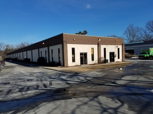
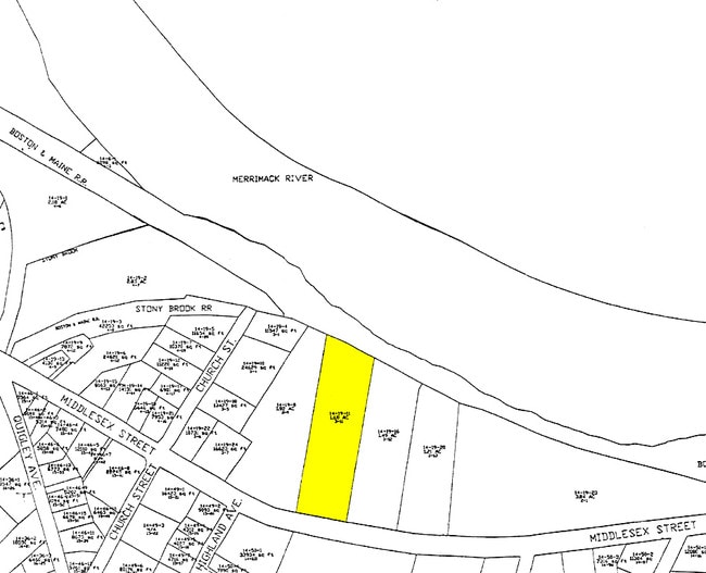
110 Middlesex St
CAMB-000195-000000-000161
MIDDLESEX
Taxexempt
Massachusetts
B
161
B and X Area of moderate flood hazard, usually the area between the limits of the 100-year and 500-year floods.
0.14 AC
0
Lowell/Chelmsford
2025
Boston
354800
Boston-Cambridge-Newton, MA-NH
NEARBY LISTINGS FOR SALE OR LEASE
DEMOGRAPHICS near 110 Middlesex St
1 mile
3 mile
5 mile
2025 Total Population
12,128
93,262
206,384
2030 Population
12,598
96,254
213,398
Pop Growth 2025-2030
+ 3.88%
+ 3.21%
+ 3.40%
Average Age
41
39
40
2025 Total Households
4,831
32,915
75,427
HH Growth 2025-2030
+ 3.91%
+ 3.38%
+ 3.58%
Median Household Inc
$95,654
$96,917
$98,405
Avg Household Size
2.40
2.60
2.60
2025 Avg HH Vehicles
2.00
2.00
2.00
Median Home Value
$479,740
$492,602
$509,872
Median Year Built
1979
1963
1965
Nearby Places
Map Layers
Map Styles
 Street
 Aerial
Layers
 Traffic
 Biking
Places
Listings with unknown addresses are not visible on the map
- Restaurants
- Banks
- Shops
- Fitness
- Groceries
PUBLIC TRANSPORTATION
TRANSIT/SUBWAY
Davis Station (Red Line - Massachusetts Bay Transportation Authority Subway (The T))
Drive
Walk
Distance
Davis Station (Red Line - Massachusetts Bay Transportation Authority Subway (The T))
2 min
12 min
0.7 mi
Porter Square Station (Red Line - Massachusetts Bay Transportation Authority Subway (The T))
Drive
Walk
Distance
Porter Square Station (Red Line - Massachusetts Bay Transportation Authority Subway (The T))
2 min
13 min
0.7 mi
Alewife (Red Line - MBTA)
Drive
Walk
Distance
Alewife (Red Line - MBTA)
2 min
15 min
0.8 mi
COMMUTER RAIL
Porter Square (Fitchburg/South Acton Line - Massachusetts Bay Transportation Authority Commuter Rail (Purple Line))
Drive
Walk
Distance
Porter Square (Fitchburg/South Acton Line - Massachusetts Bay Transportation Authority Commuter Rail (Purple Line))
3 min
13 min
0.7 mi
West Medford (Lowell Line - MBTA)
Drive
Walk
Distance
West Medford (Lowell Line - MBTA)
6 min
2.7 mi
AIRPORT
General Edward Lawrence Logan International
Drive
Walk
Distance
General Edward Lawrence Logan International
18 min
7.5 mi
Freight Ports
Port of Boston
Drive
Walk
Distance
Port of Boston
18 min
8.9 mi
SALE & LEASE HISTORY
LISTING DATE
SALE/LEASE

Feb 22, 2019
For Sale
Nearby Properties
Address
Land Use
TOTAL SIZE
Lot Size
Zoning
Address
Land Use
TOTAL SIZE
Lot Size
Zoning
439,500 SF
9.21 AC
E
Address
Land Use
TOTAL SIZE
Lot Size
Zoning
125,571 SF
3.25 AC
C-3
Address
Land Use
TOTAL SIZE
Lot Size
Zoning
150,192 SF
10.27 AC
E
Address
Land Use
TOTAL SIZE
Lot Size
Zoning
530,200 SF
62.08 AC
E
Address
Land Use
TOTAL SIZE
Lot Size
Zoning
173,400 SF
1.14 AC
MXD
Address
Land Use
TOTAL SIZE
Lot Size
Zoning
142,458 SF
1.67 AC
C-3
Address
Land Use
TOTAL SIZE
Lot Size
Zoning
230,394 SF
0.60 AC
MXD
Address
Land Use
TOTAL SIZE
Lot Size
Zoning
304,349 SF
1.72 AC
Address
Land Use
TOTAL SIZE
Lot Size
Zoning
3.52 AC
C-3
Address
Land Use
TOTAL SIZE
Lot Size
Zoning
239,377 SF
0.71 AC
MXD
Address
Land Use
TOTAL SIZE
Lot Size
Zoning
419,722 SF
2.03 AC
RC
Address
Land Use
TOTAL SIZE
Lot Size
Zoning
283,554 SF
2.76 AC
O-2A
Address
Land Use
TOTAL SIZE
Lot Size
Zoning
54,500 SF
4.01 AC
O-2A
Address
Land Use
TOTAL SIZE
Lot Size
Zoning
2.81 AC
O-2
Address
Land Use
TOTAL SIZE
Lot Size
Zoning
47.67 AC
UN
Address
Land Use
TOTAL SIZE
Lot Size
Zoning
4,355 SF
13.12 AC
E
Address
Land Use
TOTAL SIZE
Lot Size
Zoning
237,935 SF
1.27 AC
C-3
Address
Land Use
TOTAL SIZE
Lot Size
Zoning
336,518 SF
6.15 AC
I-3
Address
Land Use
TOTAL SIZE
Lot Size
Zoning
2.87 AC
O-2A
Address
Land Use
TOTAL SIZE
Lot Size
Zoning
155,818 SF
5.33 AC
OS
Address
Land Use
TOTAL SIZE
Lot Size
Zoning
506,534 SF
2.75 AC
C
Address
Land Use
TOTAL SIZE
Lot Size
Zoning
213,834 SF
1.48 AC
SD-4
Address
Land Use
TOTAL SIZE
Lot Size
Zoning
136,025 SF
6.91 AC
C3
Address
Land Use
TOTAL SIZE
Lot Size
Zoning
2.25 AC
SD-12
Address
Land Use
TOTAL SIZE
Lot Size
Zoning
224,115 SF
2.35 AC
O-2A
Address
Land Use
TOTAL SIZE
Lot Size
Zoning
158,526 SF
0.79 AC
MXD
Address
Land Use
TOTAL SIZE
Lot Size
Zoning
282,112 SF
2.51 AC
IA-1
Address
Land Use
TOTAL SIZE
Lot Size
Zoning
244,008 SF
4 AC
SD-4A
Address
Land Use
TOTAL SIZE
Lot Size
Zoning
174,764 SF
1.83 AC
C-3
Address
Land Use
TOTAL SIZE
Lot Size
Zoning
176,625 SF
5.76 AC
I-3
The World's #1 Commercial Real Estate Marketplace
Connect with us
© 2026 CoStar Group
The information above has been obtained from sources believed reliable. While we do not doubt its accuracy we have not verified it and make no guarantee, warranty or representation about it. It is your responsibility to independently confirm its accuracy and completeness. Any projections, opinions, assumptions, or estimates used are for example only and do not represent the current or future performance of the property. The value of this transaction to you depends on tax and other factors which should be evaluated by your tax, financial, and legal advisors. You and your advisors should conduct a careful, independent investigation of the property to determine to your satisfaction the suitability of the property for your needs.