Property Record
110 N Brooks St, Manning, SC 29102

NEARBY LISTINGS FOR SALE OR LEASE
Property Detail
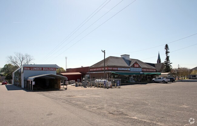
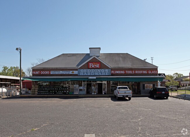
110 N Brooks St
Commercialnec
HARDWARE STORE ON BROOKS ST
X
Clarendon
45027C0254C
South Carolina
2024
0.94 AC
2024
Orangeburg/Sumter
960500
Other Market Areas
12,155 SF
187-01-02-005-00
DEMOGRAPHICS near 110 N Brooks St
1 Mile
3 Mile
5 Mile
2024 Total Population
2,911
6,434
9,327
2029 Population
2,808
6,194
8,963
Pop Growth 2024-2029
(3.54%)
(3.73%)
(3.90%)
Average Age
40
41
41
2024 Total Households
1,161
2,574
3,717
HH Growth 2024-2029
(3.45%)
(3.61%)
(3.77%)
Median Household Inc
$30,408
$35,019
$38,356
Avg Household Size
2.40
2.40
2.40
2024 Avg HH Vehicles
1.00
2.00
2.00
Median Home Value
$119,668
$124,845
$125,748
Median Year Built
1981
1983
1984
Nearby Places
Map Layers
Map Styles
 Street
 Aerial
- Restaurants
- Banks
- Shops
- Fitness
- Groceries
Nearby Properties
Address
Land Use
TOTAL SIZE
Lot Size
Zoning
Address
Land Use
TOTAL SIZE
Lot Size
Zoning
4,999 SF
8 AC
Address
Land Use
TOTAL SIZE
Lot Size
Zoning
25,288 SF
15.97 AC
Address
Land Use
TOTAL SIZE
Lot Size
Zoning
5,250 SF
3 AC
Address
Land Use
TOTAL SIZE
Lot Size
Zoning
55,583 SF
4.95 AC
Address
Land Use
TOTAL SIZE
Lot Size
Zoning
15,755 SF
3.24 AC
Address
Land Use
TOTAL SIZE
Lot Size
Zoning
190,500 SF
52.54 AC
Address
Land Use
TOTAL SIZE
Lot Size
Zoning
1,120 SF
5 AC
Address
Land Use
TOTAL SIZE
Lot Size
Zoning
25,216 SF
10 AC
Address
Land Use
TOTAL SIZE
Lot Size
Zoning
1,776 SF
4 AC
Address
Land Use
TOTAL SIZE
Lot Size
Zoning
7,176 SF
4.20 AC
Address
Land Use
TOTAL SIZE
Lot Size
Zoning
151,835 SF
20.17 AC
Address
Land Use
TOTAL SIZE
Lot Size
Zoning
6,233 SF
6.34 AC
Address
Land Use
TOTAL SIZE
Lot Size
Zoning
39.50 AC
Address
Land Use
TOTAL SIZE
Lot Size
Zoning
3,570 SF
1.40 AC
Address
Land Use
TOTAL SIZE
Lot Size
Zoning
4,811 SF
2.50 AC
Address
Land Use
TOTAL SIZE
Lot Size
Zoning
6,327 SF
0.38 AC
Address
Land Use
TOTAL SIZE
Lot Size
Zoning
2,742 SF
32.61 AC
Address
Land Use
TOTAL SIZE
Lot Size
Zoning
3,279 SF
1.01 AC
Address
Land Use
TOTAL SIZE
Lot Size
Zoning
91.01 AC
Address
Land Use
TOTAL SIZE
Lot Size
Zoning
1.15 AC
Address
Land Use
TOTAL SIZE
Lot Size
Zoning
5,546 SF
0.75 AC
Address
Land Use
TOTAL SIZE
Lot Size
Zoning
50,322 SF
2.98 AC
Address
Land Use
TOTAL SIZE
Lot Size
Zoning
20,000 SF
2.88 AC
Address
Land Use
TOTAL SIZE
Lot Size
Zoning
3.45 AC
Address
Land Use
TOTAL SIZE
Lot Size
Zoning
2,920 SF
1.08 AC
Address
Land Use
TOTAL SIZE
Lot Size
Zoning
2,102 SF
0.31 AC
Address
Land Use
TOTAL SIZE
Lot Size
Zoning
25,476 SF
2.74 AC
Address
Land Use
TOTAL SIZE
Lot Size
Zoning
41,244 SF
1.95 AC
The World's #1 Commercial Real Estate Marketplace
Connect with us
© 2026 CoStar Group
The information above has been obtained from sources believed reliable. While we do not doubt its accuracy we have not verified it and make no guarantee, warranty or representation about it. It is your responsibility to independently confirm its accuracy and completeness. Any projections, opinions, assumptions, or estimates used are for example only and do not represent the current or future performance of the property. The value of this transaction to you depends on tax and other factors which should be evaluated by your tax, financial, and legal advisors. You and your advisors should conduct a careful, independent investigation of the property to determine to your satisfaction the suitability of the property for your needs.