Property Record
110 N Williams St, Paulding, OH 45879
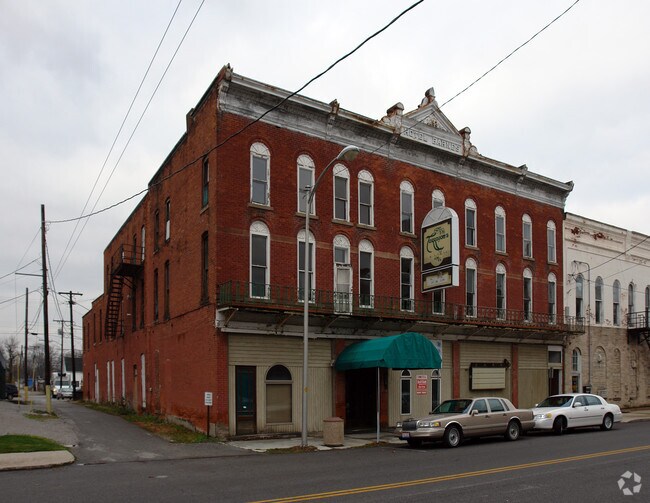


Property Detail
110 N Williams St
Other Market Areas
LOT 189 PTLESS33X66 NWCOR O.P. PAULDING VILL
30-24S-064-00
PAULDING
Commercialacreage
Ohio
B and X Area of moderate flood hazard, usually the area between the limits of the 100-year and 500-year floods.
189
2025
0.05 AC
2025
Ohio North Area
960400
NEARBY LISTINGS FOR SALE OR LEASE
-
-
View all Paulding listings for sale on LoopNet.com
DEMOGRAPHICS near 110 N Williams St
1 mile
3 mile
5 mile
2025 Total Population
2,951
4,406
5,541
2030 Population
2,953
4,415
5,555
Pop Growth 2025-2030
+ 0.07%
+ 0.20%
+ 0.25%
Average Age
40
41
41
2025 Total Households
1,244
1,857
2,311
HH Growth 2025-2030
+ 0.08%
+ 0.16%
+ 0.22%
Median Household Inc
$56,542
$55,826
$58,280
Avg Household Size
2.40
2.40
2.40
2025 Avg HH Vehicles
2.00
2.00
2.00
Median Home Value
$135,099
$140,108
$143,322
Median Year Built
1960
1963
1964
Nearby Places
Map Layers
Map Styles
 Street
 Aerial
Layers
 Traffic
 Biking
Places
Listings with unknown addresses are not visible on the map
- Restaurants
- Banks
- Shops
- Fitness
- Groceries
Nearby Properties
Address
Land Use
TOTAL SIZE
Lot Size
Zoning
Address
Land Use
TOTAL SIZE
Lot Size
Zoning
4,394 SF
8.48 AC
Address
Land Use
TOTAL SIZE
Lot Size
Zoning
64,476 SF
15 AC
Address
Land Use
TOTAL SIZE
Lot Size
Zoning
Address
Land Use
TOTAL SIZE
Lot Size
Zoning
Address
Land Use
TOTAL SIZE
Lot Size
Zoning
37,308 SF
6.69 AC
Address
Land Use
TOTAL SIZE
Lot Size
Zoning
41,957 SF
3.36 AC
Address
Land Use
TOTAL SIZE
Lot Size
Zoning
25,000 SF
11.59 AC
Address
Land Use
TOTAL SIZE
Lot Size
Zoning
111,970 SF
21.31 AC
Address
Land Use
TOTAL SIZE
Lot Size
Zoning
9,640 SF
4.09 AC
Address
Land Use
TOTAL SIZE
Lot Size
Zoning
20,768 SF
7 AC
Address
Land Use
TOTAL SIZE
Lot Size
Zoning
235.45 AC
Address
Land Use
TOTAL SIZE
Lot Size
Zoning
79,200 SF
53.14 AC
Address
Land Use
TOTAL SIZE
Lot Size
Zoning
12,520 SF
4.30 AC
Address
Land Use
TOTAL SIZE
Lot Size
Zoning
15,554 SF
136.02 AC
Address
Land Use
TOTAL SIZE
Lot Size
Zoning
3,108 SF
4.96 AC
Address
Land Use
TOTAL SIZE
Lot Size
Zoning
230.99 AC
Address
Land Use
TOTAL SIZE
Lot Size
Zoning
70,854 SF
14.36 AC
Address
Land Use
TOTAL SIZE
Lot Size
Zoning
15,094 SF
1.80 AC
Address
Land Use
TOTAL SIZE
Lot Size
Zoning
1,843 SF
169.50 AC
Address
Land Use
TOTAL SIZE
Lot Size
Zoning
13,066 SF
1.69 AC
Address
Land Use
TOTAL SIZE
Lot Size
Zoning
17,295 SF
5.02 AC
Address
Land Use
TOTAL SIZE
Lot Size
Zoning
163.41 AC
Address
Land Use
TOTAL SIZE
Lot Size
Zoning
160 AC
Address
Land Use
TOTAL SIZE
Lot Size
Zoning
161.17 AC
Address
Land Use
TOTAL SIZE
Lot Size
Zoning
237.95 AC
Address
Land Use
TOTAL SIZE
Lot Size
Zoning
158 AC
Address
Land Use
TOTAL SIZE
Lot Size
Zoning
158.05 AC
Address
Land Use
TOTAL SIZE
Lot Size
Zoning
1,816 SF
151.61 AC
Address
Land Use
TOTAL SIZE
Lot Size
Zoning
157.03 AC
Address
Land Use
TOTAL SIZE
Lot Size
Zoning
43,926 SF
9.86 AC
The World's #1 Commercial Real Estate Marketplace
Connect with us
© 2026 CoStar Group
The information above has been obtained from sources believed reliable. While we do not doubt its accuracy we have not verified it and make no guarantee, warranty or representation about it. It is your responsibility to independently confirm its accuracy and completeness. Any projections, opinions, assumptions, or estimates used are for example only and do not represent the current or future performance of the property. The value of this transaction to you depends on tax and other factors which should be evaluated by your tax, financial, and legal advisors. You and your advisors should conduct a careful, independent investigation of the property to determine to your satisfaction the suitability of the property for your needs.