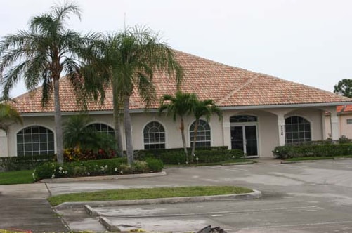
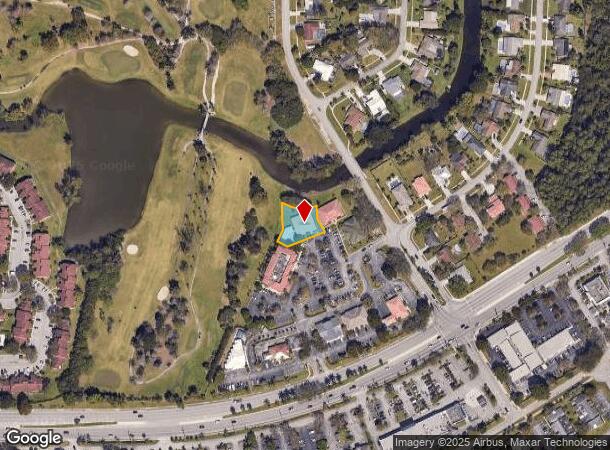
Property Record
110 Ponce De Leon St, Royal Palm Beach, FL 33411


NEARBY LISTINGS FOR SALE OR LEASE
Property Detail
110 Ponce De Leon St
West Palm Beach-Boca Raton-Delray Beach, FL
Ponce De Leon Office Park
72-41-43-23-14-000-0090
PONCE DE LEON OFFICE PARK LT 9
Officebuilding
Palm Beach
X
Florida
12099C0553F
9
2024
0.36 AC
2025
Palm Bch Cty Outlying
007841
South Florida
4,053 SF
DEMOGRAPHICS near 110 Ponce De Leon St
1 Mile
3 Mile
5 Mile
2024 Total Population
11,337
50,109
118,710
2029 Population
11,464
51,017
121,295
Pop Growth 2024-2029
+ 1.12%
+ 1.81%
+ 2.18%
Average Age
40
41
40
2024 Total Households
3,916
17,413
41,822
HH Growth 2024-2029
+ 0.41%
+ 1.12%
+ 1.53%
Median Household Inc
$75,973
$90,004
$87,103
Avg Household Size
2.80
2.70
2.70
2024 Avg HH Vehicles
2.00
2.00
2.00
Median Home Value
$321,335
$351,393
$382,283
Median Year Built
1986
1993
1992
Nearby Places
Map Layers
Map Styles
 Street
 Aerial
- Restaurants
- Banks
- Shops
- Fitness
- Groceries
PUBLIC TRANSPORTATION
AIRPORT
Palm Beach International
DRIVE
WALK
Distance
Palm Beach International
19 min
9.9 mi
Freight Ports
Port of Palm Beach
DRIVE
WALK
Distance
Port of Palm Beach
28 min
14.4 mi
Nearby Properties
Address
Land Use
TOTAL SIZE
Lot Size
Zoning
Address
Land Use
TOTAL SIZE
Lot Size
Zoning
398,622 SF
21.62 AC
RM-18
Address
Land Use
TOTAL SIZE
Lot Size
Zoning
669,818 SF
42.79 AC
IL
Address
Land Use
TOTAL SIZE
Lot Size
Zoning
428,659 SF
26.16 AC
MUPD
Address
Land Use
TOTAL SIZE
Lot Size
Zoning
349,316 SF
49.95 AC
CG
Address
Land Use
TOTAL SIZE
Lot Size
Zoning
318,687 SF
29.98 AC
RM-9
Address
Land Use
TOTAL SIZE
Lot Size
Zoning
294,321 SF
109.37 AC
PO
Address
Land Use
TOTAL SIZE
Lot Size
Zoning
159,302 SF
29.36 AC
Address
Land Use
TOTAL SIZE
Lot Size
Zoning
302,692 SF
55 AC
PO
Address
Land Use
TOTAL SIZE
Lot Size
Zoning
243,076 SF
15.47 AC
RM-18
Address
Land Use
TOTAL SIZE
Lot Size
Zoning
261,118 SF
58.77 AC
IPF
Address
Land Use
TOTAL SIZE
Lot Size
Zoning
255,345 SF
15.34 AC
IPF
Address
Land Use
TOTAL SIZE
Lot Size
Zoning
159,433 SF
38.65 AC
PO
Address
Land Use
TOTAL SIZE
Lot Size
Zoning
116,601 SF
13.94 AC
CG
Address
Land Use
TOTAL SIZE
Lot Size
Zoning
68,094 SF
39.77 AC
MUPD
Address
Land Use
TOTAL SIZE
Lot Size
Zoning
149,934 SF
3.47 AC
CG
Address
Land Use
TOTAL SIZE
Lot Size
Zoning
229,274 SF
24.34 AC
CG
Address
Land Use
TOTAL SIZE
Lot Size
Zoning
129,117 SF
12.62 AC
CG
Address
Land Use
TOTAL SIZE
Lot Size
Zoning
114,658 SF
14.99 AC
CG
Address
Land Use
TOTAL SIZE
Lot Size
Zoning
91,993 SF
10.53 AC
CG
Address
Land Use
TOTAL SIZE
Lot Size
Zoning
81,309 SF
22.90 AC
CO
Address
Land Use
TOTAL SIZE
Lot Size
Zoning
127,074 SF
7.90 AC
IL
Address
Land Use
TOTAL SIZE
Lot Size
Zoning
152,387 SF
8.46 AC
IL
Address
Land Use
TOTAL SIZE
Lot Size
Zoning
85,077 SF
4.10 AC
MXD
Address
Land Use
TOTAL SIZE
Lot Size
Zoning
180,760 SF
30 AC
PO
Address
Land Use
TOTAL SIZE
Lot Size
Zoning
78,166 SF
9.73 AC
IL
Address
Land Use
TOTAL SIZE
Lot Size
Zoning
124,420 SF
6.47 AC
IL
Address
Land Use
TOTAL SIZE
Lot Size
Zoning
180,200 SF
18.21 AC
CG
Address
Land Use
TOTAL SIZE
Lot Size
Zoning
247,676 SF
46.06 AC
PUD
Address
Land Use
TOTAL SIZE
Lot Size
Zoning
106,543 SF
18.38 AC
CS
Address
Land Use
TOTAL SIZE
Lot Size
Zoning
75,077 SF
6.40 AC
RMU
The World's #1 Commercial Real Estate Marketplace
Connect with us
© 2025 CoStar Group
The information above has been obtained from sources believed reliable. While we do not doubt its accuracy we have not verified it and make no guarantee, warranty or representation about it. It is your responsibility to independently confirm its accuracy and completeness. Any projections, opinions, assumptions, or estimates used are for example only and do not represent the current or future performance of the property. The value of this transaction to you depends on tax and other factors which should be evaluated by your tax, financial, and legal advisors. You and your advisors should conduct a careful, independent investigation of the property to determine to your satisfaction the suitability of the property for your needs.