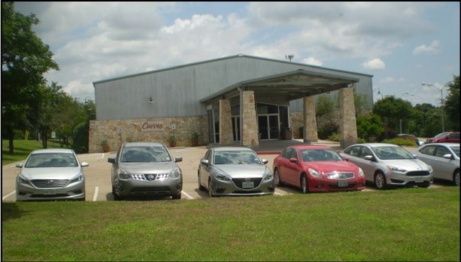
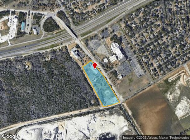
Property Record
110 Ritchie Rd, Woodway, TX 76712
NEARBY LISTINGS FOR SALE OR LEASE
Property Detail
110 Ritchie Rd
Waco, TX
Heavin Addition
36-315975-000200-0
HEAVIN ADDITION LOT 2 BLOCK 1 ACRES 7.386
Commercialnec
Mclennan
X
Texas
48309C0530D
2
0
7.39 AC
2025
Waco & Killeen
002504
Other Market Areas
21,680 SF
DEMOGRAPHICS near 110 Ritchie Rd
1 Mile
3 Mile
5 Mile
2024 Total Population
3,799
31,987
72,369
2029 Population
3,990
34,010
76,654
Pop Growth 2024-2029
+ 5.03%
+ 6.32%
+ 5.92%
Average Age
42
42
40
2024 Total Households
1,401
12,000
28,208
HH Growth 2024-2029
+ 5.21%
+ 6.48%
+ 6.06%
Median Household Inc
$133,288
$87,405
$77,791
Avg Household Size
2.70
2.50
2.50
2024 Avg HH Vehicles
2.00
2.00
2.00
Median Home Value
$358,873
$266,127
$252,441
Median Year Built
1987
1988
1986
Nearby Places
Map Layers
Map Styles
 Street
 Aerial
- Restaurants
- Banks
- Shops
- Fitness
- Groceries
PUBLIC TRANSPORTATION
AIRPORT
Waco Regional
DRIVE
WALK
Distance
Waco Regional
28 min
13.6 mi
Nearby Properties
Address
Land Use
TOTAL SIZE
Lot Size
Zoning
Address
Land Use
TOTAL SIZE
Lot Size
Zoning
106.92 AC
Address
Land Use
TOTAL SIZE
Lot Size
Zoning
Address
Land Use
TOTAL SIZE
Lot Size
Zoning
16,678 SF
19.91 AC
C3
Address
Land Use
TOTAL SIZE
Lot Size
Zoning
Address
Land Use
TOTAL SIZE
Lot Size
Zoning
222,388 SF
10.68 AC
R-3C
Address
Land Use
TOTAL SIZE
Lot Size
Zoning
221,876 SF
12.26 AC
C-2
Address
Land Use
TOTAL SIZE
Lot Size
Zoning
211,432 SF
13.86 AC
O2
Address
Land Use
TOTAL SIZE
Lot Size
Zoning
Address
Land Use
TOTAL SIZE
Lot Size
Zoning
108,969 SF
24.73 AC
R-1
Address
Land Use
TOTAL SIZE
Lot Size
Zoning
99,179 SF
54.16 AC
R1
Address
Land Use
TOTAL SIZE
Lot Size
Zoning
223,307 SF
27.28 AC
O-2,
Address
Land Use
TOTAL SIZE
Lot Size
Zoning
87,492 SF
29.99 AC
R1
Address
Land Use
TOTAL SIZE
Lot Size
Zoning
80,890 SF
13.08 AC
O1
Address
Land Use
TOTAL SIZE
Lot Size
Zoning
69,600 SF
2 AC
Address
Land Use
TOTAL SIZE
Lot Size
Zoning
198,670 SF
10.24 AC
M1
Address
Land Use
TOTAL SIZE
Lot Size
Zoning
174,456 SF
9.04 AC
R3C
Address
Land Use
TOTAL SIZE
Lot Size
Zoning
212,934 SF
21.91 AC
C3
Address
Land Use
TOTAL SIZE
Lot Size
Zoning
72,920 SF
11 AC
C-3
Address
Land Use
TOTAL SIZE
Lot Size
Zoning
Address
Land Use
TOTAL SIZE
Lot Size
Zoning
Address
Land Use
TOTAL SIZE
Lot Size
Zoning
86,014 SF
11.87 AC
R1
Address
Land Use
TOTAL SIZE
Lot Size
Zoning
94,262 SF
8.57 AC
CS
Address
Land Use
TOTAL SIZE
Lot Size
Zoning
82.98 AC
M-2
Address
Land Use
TOTAL SIZE
Lot Size
Zoning
65,016 SF
5.08 AC
C-2
Address
Land Use
TOTAL SIZE
Lot Size
Zoning
80,437 SF
30.43 AC
C
Address
Land Use
TOTAL SIZE
Lot Size
Zoning
114,575 SF
4.20 AC
Address
Land Use
TOTAL SIZE
Lot Size
Zoning
156,531 SF
7.51 AC
R-4
Address
Land Use
TOTAL SIZE
Lot Size
Zoning
50,194 SF
6.40 AC
Address
Land Use
TOTAL SIZE
Lot Size
Zoning
17 AC
R
Address
Land Use
TOTAL SIZE
Lot Size
Zoning
The World's #1 Commercial Real Estate Marketplace
Connect with us
© 2025 CoStar Group
The information above has been obtained from sources believed reliable. While we do not doubt its accuracy we have not verified it and make no guarantee, warranty or representation about it. It is your responsibility to independently confirm its accuracy and completeness. Any projections, opinions, assumptions, or estimates used are for example only and do not represent the current or future performance of the property. The value of this transaction to you depends on tax and other factors which should be evaluated by your tax, financial, and legal advisors. You and your advisors should conduct a careful, independent investigation of the property to determine to your satisfaction the suitability of the property for your needs.