Property Record
110 S 243Rd St, Waterloo, NE 68069

Save to a Folder
{{folder.Name}}
{{folder.ListingIds.length}} Properties
{{folder.ListingIds.length}} Property
Create a New Folder
Property Detail
110 S 243Rd St
2450-0832-25
WEST SHORES REPLAT 4 LOT 2 BLOCK 0 IRREG 87629 SQ FT
Nightclub
DOUGLAS
GC
Nebraska
AE The base floodplain where base flood elevations are provided. AE Zones are now used on new format FIRMs instead of A1-A30 Zones.
2
2024
2.01 AC
2025
Suburban West Dodge
007508
Omaha/Council Bluffs
43,266 SF
Omaha, NE-IA
NEARBY LISTINGS FOR SALE OR LEASE
DEMOGRAPHICS near 110 S 243Rd St
1 mile
3 mile
5 mile
2025 Total Population
652
8,940
48,474
2030 Population
680
9,356
51,335
Pop Growth 2025-2030
+ 4.29%
+ 4.65%
+ 5.90%
Average Age
49
41
38
2025 Total Households
276
3,110
17,360
HH Growth 2025-2030
+ 4.71%
+ 4.79%
+ 6.04%
Median Household Inc
$128,846
$144,193
$139,541
Avg Household Size
2.40
2.80
2.80
2025 Avg HH Vehicles
2.00
2.00
2.00
Median Home Value
$601,852
$504,059
$473,133
Median Year Built
1983
1992
2009
Nearby Places
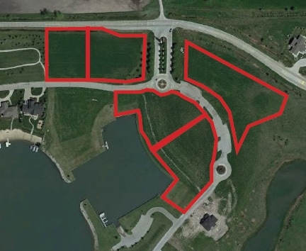
Map Layers
Map Styles
 Street
 Aerial
Layers
 Traffic
 Biking
Places
Listings with unknown addresses are not visible on the map
- Restaurants
- Banks
- Shops
- Fitness
- Groceries
PUBLIC TRANSPORTATION
AIRPORT
Eppley Airfield
Drive
Walk
Distance
Eppley Airfield
41 min
22.9 mi
SALE & LEASE HISTORY
LISTING DATE
SALE/LEASE

May 19, 2017
For Sale
Nearby Properties
Address
Land Use
TOTAL SIZE
Lot Size
Zoning
Address
Land Use
TOTAL SIZE
Lot Size
Zoning
272,916 SF
27.09 AC
Address
Land Use
TOTAL SIZE
Lot Size
Zoning
144,006 SF
5.86 AC
Address
Land Use
TOTAL SIZE
Lot Size
Zoning
132,938 SF
7.76 AC
Address
Land Use
TOTAL SIZE
Lot Size
Zoning
109,698 SF
4.35 AC
CC
Address
Land Use
TOTAL SIZE
Lot Size
Zoning
61,850 SF
1.31 AC
Address
Land Use
TOTAL SIZE
Lot Size
Zoning
53,294 SF
3.27 AC
Address
Land Use
TOTAL SIZE
Lot Size
Zoning
44,304 SF
4.21 AC
Address
Land Use
TOTAL SIZE
Lot Size
Zoning
86,480 SF
5.76 AC
Address
Land Use
TOTAL SIZE
Lot Size
Zoning
73,505 SF
4.09 AC
Address
Land Use
TOTAL SIZE
Lot Size
Zoning
32,665 SF
9.63 AC
Address
Land Use
TOTAL SIZE
Lot Size
Zoning
56,640 SF
3.72 AC
Address
Land Use
TOTAL SIZE
Lot Size
Zoning
25,685 SF
2.80 AC
CC
Address
Land Use
TOTAL SIZE
Lot Size
Zoning
25,351 SF
5.73 AC
Address
Land Use
TOTAL SIZE
Lot Size
Zoning
30,000 SF
1.68 AC
Address
Land Use
TOTAL SIZE
Lot Size
Zoning
20,164 SF
1.60 AC
Address
Land Use
TOTAL SIZE
Lot Size
Zoning
17,760 SF
Address
Land Use
TOTAL SIZE
Lot Size
Zoning
56,200 SF
9.02 AC
Address
Land Use
TOTAL SIZE
Lot Size
Zoning
25,929 SF
1.65 AC
Address
Land Use
TOTAL SIZE
Lot Size
Zoning
22,000 SF
3.25 AC
CC
Address
Land Use
TOTAL SIZE
Lot Size
Zoning
48,600 SF
5.23 AC
Address
Land Use
TOTAL SIZE
Lot Size
Zoning
25,929 SF
1.57 AC
Address
Land Use
TOTAL SIZE
Lot Size
Zoning
18,000 SF
4 AC
Address
Land Use
TOTAL SIZE
Lot Size
Zoning
29,063 SF
3.07 AC
CC
Address
Land Use
TOTAL SIZE
Lot Size
Zoning
79,600 SF
1.67 AC
Address
Land Use
TOTAL SIZE
Lot Size
Zoning
36,000 SF
4.06 AC
CC
Address
Land Use
TOTAL SIZE
Lot Size
Zoning
13,600 SF
1.20 AC
Address
Land Use
TOTAL SIZE
Lot Size
Zoning
32,772 SF
3.15 AC
WATERLOO
Address
Land Use
TOTAL SIZE
Lot Size
Zoning
12,300 SF
1.46 AC
The World's #1 Commercial Real Estate Marketplace
Connect with us
© 2026 CoStar Group
The information above has been obtained from sources believed reliable. While we do not doubt its accuracy we have not verified it and make no guarantee, warranty or representation about it. It is your responsibility to independently confirm its accuracy and completeness. Any projections, opinions, assumptions, or estimates used are for example only and do not represent the current or future performance of the property. The value of this transaction to you depends on tax and other factors which should be evaluated by your tax, financial, and legal advisors. You and your advisors should conduct a careful, independent investigation of the property to determine to your satisfaction the suitability of the property for your needs.