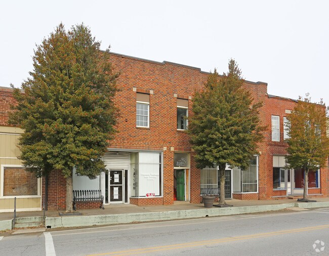
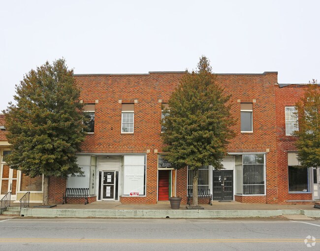
Property Record
110 S Main St, Grover, NC 28073

Property Detail
110 S Main St
6392
LOT MAIN ST STORE
Storebuilding
Cleveland
GB
North Carolina
B and X Area of moderate flood hazard, usually the area between the limits of the 100-year and 500-year floods.
2
2025
0.15 AC
2025
Cleveland County
950604
Charlotte
5,550 SF
Shelby-Kings Mountain, NC
NEARBY LISTINGS FOR SALE OR LEASE
-
-
View all Grover listings for lease on LoopNet.com
DEMOGRAPHICS near 110 S Main St
1 mile
3 mile
5 mile
2025 Total Population
1,173
4,783
12,923
2030 Population
1,197
4,901
13,257
Pop Growth 2025-2030
+ 2.05%
+ 2.47%
+ 2.58%
Average Age
39
41
41
2025 Total Households
443
1,865
5,074
HH Growth 2025-2030
+ 2.03%
+ 2.47%
+ 2.58%
Median Household Inc
$46,577
$56,806
$60,605
Avg Household Size
2.70
2.60
2.50
2025 Avg HH Vehicles
2.00
2.00
2.00
Median Home Value
$215,411
$197,563
$190,257
Median Year Built
1974
1987
1987
Nearby Places
Map Layers
Map Styles
 Street
 Aerial
Transit
 Traffic
 Biking
Places
Listings with unknown addresses are not visible on the map
- Restaurants
- Banks
- Shops
- Fitness
- Groceries
PUBLIC TRANSPORTATION
AIRPORT
Charlotte/Douglas International
Drive
Walk
Distance
Charlotte/Douglas International
51 min
34.7 mi
Freight Ports
North Charleston Terminal
Drive
Walk
Distance
North Charleston Terminal
246 min
213.3 mi
SALE & LEASE HISTORY
LISTING DATE
SALE/LEASE

Sep 25, 2016
For Lease
Nearby Properties
Address
Land Use
TOTAL SIZE
Lot Size
Zoning
Address
Land Use
TOTAL SIZE
Lot Size
Zoning
148,809 SF
99.49 AC
LI
Address
Land Use
TOTAL SIZE
Lot Size
Zoning
295,045 SF
45.35 AC
LI
Address
Land Use
TOTAL SIZE
Lot Size
Zoning
3,000 SF
19.94 AC
HI
Address
Land Use
TOTAL SIZE
Lot Size
Zoning
18,952 SF
6 AC
AA1
Address
Land Use
TOTAL SIZE
Lot Size
Zoning
51,480 SF
7.94 AC
LI
Address
Land Use
TOTAL SIZE
Lot Size
Zoning
2,210 SF
2.96 AC
R15
Address
Land Use
TOTAL SIZE
Lot Size
Zoning
25,000 SF
9.65 AC
LI
Address
Land Use
TOTAL SIZE
Lot Size
Zoning
2,700 SF
11.39 AC
HI
Address
Land Use
TOTAL SIZE
Lot Size
Zoning
21,248 SF
24.69 AC
LI
Address
Land Use
TOTAL SIZE
Lot Size
Zoning
40,000 SF
11.11 AC
AA3
Address
Land Use
TOTAL SIZE
Lot Size
Zoning
7,200 SF
10.85 AC
HI
Address
Land Use
TOTAL SIZE
Lot Size
Zoning
5,143 SF
199.95 AC
LI
Address
Land Use
TOTAL SIZE
Lot Size
Zoning
18,542 SF
9.80 AC
LI
Address
Land Use
TOTAL SIZE
Lot Size
Zoning
38,960 SF
199 AC
LI
Address
Land Use
TOTAL SIZE
Lot Size
Zoning
34,300 SF
12.34 AC
LI
Address
Land Use
TOTAL SIZE
Lot Size
Zoning
12,257 SF
1.96 AC
AA1
Address
Land Use
TOTAL SIZE
Lot Size
Zoning
4,506 SF
6.76 AC
R15
Address
Land Use
TOTAL SIZE
Lot Size
Zoning
5.19 AC
Address
Land Use
TOTAL SIZE
Lot Size
Zoning
476,000 SF
38.40 AC
Address
Land Use
TOTAL SIZE
Lot Size
Zoning
63.43 AC
Address
Land Use
TOTAL SIZE
Lot Size
Zoning
2,800 SF
4 AC
R15
Address
Land Use
TOTAL SIZE
Lot Size
Zoning
24,425 SF
28.40 AC
HI
Address
Land Use
TOTAL SIZE
Lot Size
Zoning
44.34 AC
AA1
Address
Land Use
TOTAL SIZE
Lot Size
Zoning
1,848 SF
5.81 AC
LI
Address
Land Use
TOTAL SIZE
Lot Size
Zoning
71.69 AC
R15
Address
Land Use
TOTAL SIZE
Lot Size
Zoning
40.27 AC
LI
Address
Land Use
TOTAL SIZE
Lot Size
Zoning
3,996 SF
7.16 AC
R15
Address
Land Use
TOTAL SIZE
Lot Size
Zoning
1,493 SF
2.55 AC
LI
Address
Land Use
TOTAL SIZE
Lot Size
Zoning
2,336 SF
4 AC
R15
Address
Land Use
TOTAL SIZE
Lot Size
Zoning
31.78 AC
The World's #1 Commercial Real Estate Marketplace
Connect with us
© 2026 CoStar Group
The information above has been obtained from sources believed reliable. While we do not doubt its accuracy we have not verified it and make no guarantee, warranty or representation about it. It is your responsibility to independently confirm its accuracy and completeness. Any projections, opinions, assumptions, or estimates used are for example only and do not represent the current or future performance of the property. The value of this transaction to you depends on tax and other factors which should be evaluated by your tax, financial, and legal advisors. You and your advisors should conduct a careful, independent investigation of the property to determine to your satisfaction the suitability of the property for your needs.