Property Record
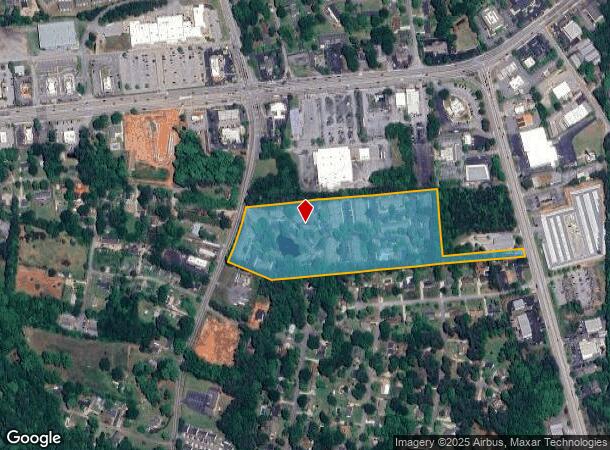
110 Southport Rd, Spartanburg, SC 29306

NEARBY LISTINGS FOR SALE OR LEASE
-
-
View all Spartanburg listings for sale on LoopNet.com
Property Detail
110 Southport Rd
6-21-14-064.04
Flournoy Development Company
Commercialnec
TRACT E FLOURNOY DEVELOPMENT COMPANY SURVEY & P/O TRACT D PULLIAM INV COMPANY SURVEY PB 97-903 PB 95
X
Spartanburg
45083C0261E
South Carolina
0
15 AC
2025
South Spartanburg County
022007
Greenville/Spartanburg
20,844 SF
Spartanburg, SC
DEMOGRAPHICS near 110 Southport Rd
1 Mile
3 Mile
5 Mile
2024 Total Population
6,212
50,462
95,871
2029 Population
7,025
57,523
108,923
Pop Growth 2024-2029
+ 13.09%
+ 13.99%
+ 13.61%
Average Age
38
38
38
2024 Total Households
2,613
20,122
37,241
HH Growth 2024-2029
+ 13.32%
+ 14.24%
+ 14.07%
Median Household Inc
$50,899
$49,386
$49,970
Avg Household Size
2.30
2.40
2.40
2024 Avg HH Vehicles
2.00
2.00
2.00
Median Home Value
$160,242
$163,179
$171,652
Median Year Built
1976
1982
1980
Nearby Places
Map Layers
Map Styles
 Street
 Aerial
- Restaurants
- Banks
- Shops
- Fitness
- Groceries
PUBLIC TRANSPORTATION
COMMUTER RAIL
Spartanburg Amtrak Station (Crescent - Amtrak)
DRIVE
WALK
Distance
Spartanburg Amtrak Station (Crescent - Amtrak)
9 min
3.9 mi
AIRPORT
Greenville Spartanburg International
DRIVE
WALK
Distance
Greenville Spartanburg International
30 min
18.1 mi
Freight Ports
North Charleston Terminal
DRIVE
WALK
Distance
North Charleston Terminal
216 min
193.1 mi
Nearby Properties
Address
Land Use
TOTAL SIZE
Lot Size
Zoning
Address
Land Use
TOTAL SIZE
Lot Size
Zoning
5,130 SF
19.69 AC
Address
Land Use
TOTAL SIZE
Lot Size
Zoning
3,352 SF
14 AC
Address
Land Use
TOTAL SIZE
Lot Size
Zoning
2,134 SF
27.72 AC
Address
Land Use
TOTAL SIZE
Lot Size
Zoning
50,096 SF
5.88 AC
Address
Land Use
TOTAL SIZE
Lot Size
Zoning
2,112 SF
5.26 AC
Address
Land Use
TOTAL SIZE
Lot Size
Zoning
6,148 SF
4.18 AC
Address
Land Use
TOTAL SIZE
Lot Size
Zoning
7,245 SF
18.10 AC
Address
Land Use
TOTAL SIZE
Lot Size
Zoning
2,100 SF
10.12 AC
Address
Land Use
TOTAL SIZE
Lot Size
Zoning
3,171 SF
21.41 AC
Address
Land Use
TOTAL SIZE
Lot Size
Zoning
2,297 SF
42.76 AC
Address
Land Use
TOTAL SIZE
Lot Size
Zoning
40,995 SF
0.74 AC
Address
Land Use
TOTAL SIZE
Lot Size
Zoning
8,140 SF
20.42 AC
Address
Land Use
TOTAL SIZE
Lot Size
Zoning
30,016 SF
1.07 AC
Address
Land Use
TOTAL SIZE
Lot Size
Zoning
31,054 SF
0.48 AC
Address
Land Use
TOTAL SIZE
Lot Size
Zoning
3,072 SF
5.60 AC
Address
Land Use
TOTAL SIZE
Lot Size
Zoning
2,176 SF
20.63 AC
Address
Land Use
TOTAL SIZE
Lot Size
Zoning
23,884 SF
3.90 AC
Address
Land Use
TOTAL SIZE
Lot Size
Zoning
227,480 SF
22.22 AC
Address
Land Use
TOTAL SIZE
Lot Size
Zoning
2,740 SF
20.62 AC
Address
Land Use
TOTAL SIZE
Lot Size
Zoning
109,024 SF
2.30 AC
Address
Land Use
TOTAL SIZE
Lot Size
Zoning
5,888 SF
17.04 AC
Address
Land Use
TOTAL SIZE
Lot Size
Zoning
2,831 SF
10.07 AC
Address
Land Use
TOTAL SIZE
Lot Size
Zoning
69,836 SF
7.56 AC
Address
Land Use
TOTAL SIZE
Lot Size
Zoning
6,820 SF
1.71 AC
Address
Land Use
TOTAL SIZE
Lot Size
Zoning
25,380 SF
0.75 AC
Address
Land Use
TOTAL SIZE
Lot Size
Zoning
335,628 SF
17.93 AC
Address
Land Use
TOTAL SIZE
Lot Size
Zoning
6,907 SF
17.39 AC
Address
Land Use
TOTAL SIZE
Lot Size
Zoning
157,500 SF
8.85 AC
Address
Land Use
TOTAL SIZE
Lot Size
Zoning
1,475 SF
9.27 AC
Address
Land Use
TOTAL SIZE
Lot Size
Zoning
128,060 SF
18.70 AC
The World's #1 Commercial Real Estate Marketplace
Connect with us
© 2026 CoStar Group
The information above has been obtained from sources believed reliable. While we do not doubt its accuracy we have not verified it and make no guarantee, warranty or representation about it. It is your responsibility to independently confirm its accuracy and completeness. Any projections, opinions, assumptions, or estimates used are for example only and do not represent the current or future performance of the property. The value of this transaction to you depends on tax and other factors which should be evaluated by your tax, financial, and legal advisors. You and your advisors should conduct a careful, independent investigation of the property to determine to your satisfaction the suitability of the property for your needs.