Property Record
110 Twenty Nine Ct, Williamston, SC 29697
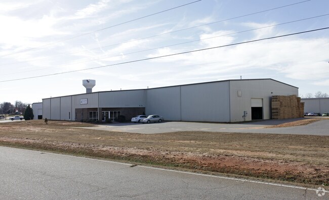

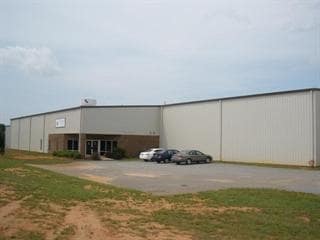
Property Detail
110 Twenty Nine Ct
220-09-01-012
CP 000/000 PP S 1498/10A F000 D000 PP 1459/5+6 TWENTY NINE CT 1.71 AC
Warehouse
Anderson
B and X Area of moderate flood hazard, usually the area between the limits of the 100-year and 500-year floods.
South Carolina
2025
1.71 AC
2025
Outlying Anderson Co
010502
Greenville/Spartanburg
24,070 SF
Greenville-Anderson-Greer, SC
NEARBY LISTINGS FOR SALE OR LEASE
DEMOGRAPHICS near 110 Twenty Nine Ct
1 mile
3 mile
5 mile
2025 Total Population
1,312
10,350
28,146
2030 Population
1,378
10,905
29,750
Pop Growth 2025-2030
+ 5.03%
+ 5.36%
+ 5.70%
Average Age
40
40
40
2025 Total Households
492
3,912
10,669
HH Growth 2025-2030
+ 5.28%
+ 5.62%
+ 5.97%
Median Household Inc
$90,371
$76,380
$68,787
Avg Household Size
2.60
2.60
2.60
2025 Avg HH Vehicles
3.00
2.00
2.00
Median Home Value
$256,474
$238,840
$233,920
Median Year Built
1991
1992
1991
Nearby Places
Map Layers
Map Styles
 Street
 Aerial
Layers
 Traffic
 Biking
Places
Listings with unknown addresses are not visible on the map
- Restaurants
- Banks
- Shops
- Fitness
- Groceries
PUBLIC TRANSPORTATION
AIRPORT
Greenville Spartanburg International
Drive
Walk
Distance
Greenville Spartanburg International
40 min
29.8 mi
Nearby Properties
Address
Land Use
TOTAL SIZE
Lot Size
Zoning
Address
Land Use
TOTAL SIZE
Lot Size
Zoning
109.52 AC
Address
Land Use
TOTAL SIZE
Lot Size
Zoning
12.84 AC
Address
Land Use
TOTAL SIZE
Lot Size
Zoning
38.40 AC
Address
Land Use
TOTAL SIZE
Lot Size
Zoning
15.62 AC
Address
Land Use
TOTAL SIZE
Lot Size
Zoning
40,884 SF
2.66 AC
Address
Land Use
TOTAL SIZE
Lot Size
Zoning
12.98 AC
Address
Land Use
TOTAL SIZE
Lot Size
Zoning
19,038 SF
10.44 AC
Address
Land Use
TOTAL SIZE
Lot Size
Zoning
10.88 AC
Address
Land Use
TOTAL SIZE
Lot Size
Zoning
9,793 SF
27.30 AC
Address
Land Use
TOTAL SIZE
Lot Size
Zoning
70,000 SF
4.52 AC
Address
Land Use
TOTAL SIZE
Lot Size
Zoning
27,700 SF
8.99 AC
Address
Land Use
TOTAL SIZE
Lot Size
Zoning
4,416 SF
6.74 AC
Address
Land Use
TOTAL SIZE
Lot Size
Zoning
1,546 SF
1.16 AC
Address
Land Use
TOTAL SIZE
Lot Size
Zoning
9,088 SF
2.29 AC
Address
Land Use
TOTAL SIZE
Lot Size
Zoning
54,106 SF
5.28 AC
Address
Land Use
TOTAL SIZE
Lot Size
Zoning
10,000 SF
2.29 AC
Address
Land Use
TOTAL SIZE
Lot Size
Zoning
22,080 SF
2.22 AC
Address
Land Use
TOTAL SIZE
Lot Size
Zoning
8,000 SF
1.03 AC
Address
Land Use
TOTAL SIZE
Lot Size
Zoning
29,538 SF
12.68 AC
Address
Land Use
TOTAL SIZE
Lot Size
Zoning
10,000 SF
1.25 AC
Address
Land Use
TOTAL SIZE
Lot Size
Zoning
8,851 SF
179.78 AC
Address
Land Use
TOTAL SIZE
Lot Size
Zoning
300 SF
1.54 AC
Address
Land Use
TOTAL SIZE
Lot Size
Zoning
2,604 SF
0.69 AC
Address
Land Use
TOTAL SIZE
Lot Size
Zoning
7,450 SF
1.61 AC
Address
Land Use
TOTAL SIZE
Lot Size
Zoning
19,900 SF
2.05 AC
Address
Land Use
TOTAL SIZE
Lot Size
Zoning
5,000 SF
7.41 AC
The World's #1 Commercial Real Estate Marketplace
Connect with us
© 2026 CoStar Group
The information above has been obtained from sources believed reliable. While we do not doubt its accuracy we have not verified it and make no guarantee, warranty or representation about it. It is your responsibility to independently confirm its accuracy and completeness. Any projections, opinions, assumptions, or estimates used are for example only and do not represent the current or future performance of the property. The value of this transaction to you depends on tax and other factors which should be evaluated by your tax, financial, and legal advisors. You and your advisors should conduct a careful, independent investigation of the property to determine to your satisfaction the suitability of the property for your needs.