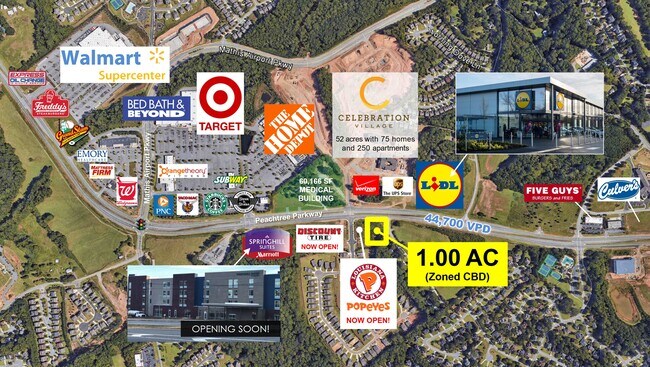
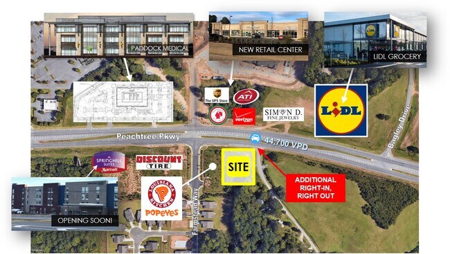
Property Record
110 Vaughan Rd, Suwanee, GA 30024

Property Detail
110 Vaughan Rd
113-884
2-1 1092 TR B
Commercialnec
FORSYTH
CBD
Georgia
B and X Area of moderate flood hazard, usually the area between the limits of the 100-year and 500-year floods.
1 AC
2024
N Fulton/Forsyth County
2025
Atlanta
130606
Atlanta-Sandy Springs-Roswell, GA
NEARBY LISTINGS FOR SALE OR LEASE
DEMOGRAPHICS near 110 Vaughan Rd
1 mile
3 mile
5 mile
2025 Total Population
8,284
66,916
178,263
2030 Population
8,909
70,281
186,915
Pop Growth 2025-2030
+ 7.54%
+ 5.03%
+ 4.85%
Average Age
40
39
39
2025 Total Households
2,712
21,151
58,164
HH Growth 2025-2030
+ 7.49%
+ 4.92%
+ 4.72%
Median Household Inc
$154,962
$178,933
$162,641
Avg Household Size
3.00
3.10
3.00
2025 Avg HH Vehicles
2.00
2.00
2.00
Median Home Value
$695,918
$711,861
$683,935
Median Year Built
2001
1999
2000
Nearby Places
Map Layers
Map Styles
 Street
 Aerial
Layers
 Traffic
 Biking
Places
Listings with unknown addresses are not visible on the map
- Restaurants
- Banks
- Shops
- Fitness
- Groceries
PUBLIC TRANSPORTATION
AIRPORT
Hartsfield - Jackson Atlanta International
Drive
Walk
Distance
Hartsfield - Jackson Atlanta International
59 min
40.6 mi
SALE & LEASE HISTORY
LISTING DATE
SALE/LEASE

Oct 12, 2022
For Lease
Nearby Properties
Address
Land Use
TOTAL SIZE
Lot Size
Zoning
Address
Land Use
TOTAL SIZE
Lot Size
Zoning
321,541 SF
63.16 AC
OI
Address
Land Use
TOTAL SIZE
Lot Size
Zoning
2,044,910 SF
30.61 AC
CUP
Address
Land Use
TOTAL SIZE
Lot Size
Zoning
559,910 SF
74.65 AC
Address
Land Use
TOTAL SIZE
Lot Size
Zoning
299,952 SF
23.49 AC
MIAC
Address
Land Use
TOTAL SIZE
Lot Size
Zoning
321,116 SF
17.06 AC
CBD
Address
Land Use
TOTAL SIZE
Lot Size
Zoning
47,721 SF
12.99 AC
CBD
Address
Land Use
TOTAL SIZE
Lot Size
Zoning
244,177 SF
8.96 AC
MIXU
Address
Land Use
TOTAL SIZE
Lot Size
Zoning
214,626 SF
6.29 AC
Address
Land Use
TOTAL SIZE
Lot Size
Zoning
629,088 SF
19.23 AC
CUP
Address
Land Use
TOTAL SIZE
Lot Size
Zoning
249,386 SF
33.24 AC
RES6
Address
Land Use
TOTAL SIZE
Lot Size
Zoning
289,676 SF
4.03 AC
C1
Address
Land Use
TOTAL SIZE
Lot Size
Zoning
291,232 SF
71.66 AC
RES3
Address
Land Use
TOTAL SIZE
Lot Size
Zoning
170,400 SF
24.98 AC
M1
Address
Land Use
TOTAL SIZE
Lot Size
Zoning
222,893 SF
103.13 AC
M1
Address
Land Use
TOTAL SIZE
Lot Size
Zoning
141,728 SF
32.45 AC
M1
Address
Land Use
TOTAL SIZE
Lot Size
Zoning
232,832 SF
17.74 AC
M1
Address
Land Use
TOTAL SIZE
Lot Size
Zoning
343,180 SF
17.29 AC
OI
Address
Land Use
TOTAL SIZE
Lot Size
Zoning
122,964 SF
7.82 AC
RES6
Address
Land Use
TOTAL SIZE
Lot Size
Zoning
163,592 SF
17.60 AC
OI
Address
Land Use
TOTAL SIZE
Lot Size
Zoning
1,845 SF
56.22 AC
AG1
Address
Land Use
TOTAL SIZE
Lot Size
Zoning
184,680 SF
18.22 AC
M1
Address
Land Use
TOTAL SIZE
Lot Size
Zoning
133,800 SF
5.20 AC
C1
Address
Land Use
TOTAL SIZE
Lot Size
Zoning
21.36 AC
MIXU
Address
Land Use
TOTAL SIZE
Lot Size
Zoning
91,296 SF
12.76 AC
CBD
Address
Land Use
TOTAL SIZE
Lot Size
Zoning
14,880 SF
16.51 AC
CBD
Address
Land Use
TOTAL SIZE
Lot Size
Zoning
101,510 SF
15.45 AC
CBD
Address
Land Use
TOTAL SIZE
Lot Size
Zoning
102,784 SF
9.16 AC
MIAC
Address
Land Use
TOTAL SIZE
Lot Size
Zoning
45,603 SF
8.36 AC
CBD
Address
Land Use
TOTAL SIZE
Lot Size
Zoning
126,793 SF
10.78 AC
M1
Address
Land Use
TOTAL SIZE
Lot Size
Zoning
117,036 SF
13.62 AC
CBD
The World's #1 Commercial Real Estate Marketplace
Connect with us
© 2026 CoStar Group
The information above has been obtained from sources believed reliable. While we do not doubt its accuracy we have not verified it and make no guarantee, warranty or representation about it. It is your responsibility to independently confirm its accuracy and completeness. Any projections, opinions, assumptions, or estimates used are for example only and do not represent the current or future performance of the property. The value of this transaction to you depends on tax and other factors which should be evaluated by your tax, financial, and legal advisors. You and your advisors should conduct a careful, independent investigation of the property to determine to your satisfaction the suitability of the property for your needs.