Property Record
110 Westside Dr, Lagrange, GA 30240
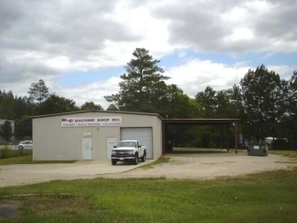

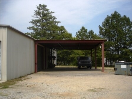

Property Detail
110 Westside Dr
071-1D-000-015
110 WESTSIDE DR/PB 20B PG 216 LT-12
Autorepair
Troup
16- CP-GB
Georgia
B and X Area of moderate flood hazard, usually the area between the limits of the 100-year and 500-year floods.
12
2025
0.76 AC
2025
Troup County
960901
Columbus GA
4,059 SF
LaGrange, GA-AL
NEARBY LISTINGS FOR SALE OR LEASE
DEMOGRAPHICS near 110 Westside Dr
1 mile
3 mile
5 mile
2025 Total Population
1,901
15,398
38,249
2030 Population
1,933
15,917
39,461
Pop Growth 2025-2030
+ 1.68%
+ 3.37%
+ 3.17%
Average Age
39
39
39
2025 Total Households
817
5,999
14,857
HH Growth 2025-2030
+ 1.96%
+ 3.62%
+ 3.37%
Median Household Inc
$34,762
$50,291
$54,272
Avg Household Size
2.20
2.50
2.50
2025 Avg HH Vehicles
1.00
2.00
2.00
Median Home Value
$96,628
$210,772
$228,380
Median Year Built
1991
1976
1982
Nearby Places
Map Layers
Map Styles
 Street
 Aerial
Transit
 Traffic
 Biking
Places
Listings with unknown addresses are not visible on the map
- Restaurants
- Banks
- Shops
- Fitness
- Groceries
PUBLIC TRANSPORTATION
AIRPORT
Columbus
Drive
Walk
Distance
Columbus
57 min
40.0 mi
Nearby Properties
Address
Land Use
TOTAL SIZE
Lot Size
Zoning
Address
Land Use
TOTAL SIZE
Lot Size
Zoning
497,181 SF
272.91 AC
16- CP-GI
Address
Land Use
TOTAL SIZE
Lot Size
Zoning
35,964 SF
72.39 AC
16- CP-GI
Address
Land Use
TOTAL SIZE
Lot Size
Zoning
2,095 SF
16.50 AC
16- CP-GB
Address
Land Use
TOTAL SIZE
Lot Size
Zoning
17,328 SF
9.75 AC
16- CP-GB
Address
Land Use
TOTAL SIZE
Lot Size
Zoning
525,250 SF
45.33 AC
16- CP-GI
Address
Land Use
TOTAL SIZE
Lot Size
Zoning
35,269 SF
22.34 AC
16- CR-MR
Address
Land Use
TOTAL SIZE
Lot Size
Zoning
109,533 SF
1.80 AC
16- DT-MX
Address
Land Use
TOTAL SIZE
Lot Size
Zoning
95,472 SF
30.05 AC
16- CR-MR
Address
Land Use
TOTAL SIZE
Lot Size
Zoning
4,909 SF
715.68 AC
16- CP-GI
Address
Land Use
TOTAL SIZE
Lot Size
Zoning
174,899 SF
7.52 AC
16- TN-R
Address
Land Use
TOTAL SIZE
Lot Size
Zoning
323,137 SF
34.65 AC
16- CP-GI
Address
Land Use
TOTAL SIZE
Lot Size
Zoning
757,316 SF
72.64 AC
16- CP-GI
Address
Land Use
TOTAL SIZE
Lot Size
Zoning
Address
Land Use
TOTAL SIZE
Lot Size
Zoning
343,734 SF
19.82 AC
16- CP-GI
Address
Land Use
TOTAL SIZE
Lot Size
Zoning
Address
Land Use
TOTAL SIZE
Lot Size
Zoning
484,700 SF
54.09 AC
16- CP-GI
Address
Land Use
TOTAL SIZE
Lot Size
Zoning
53,565 SF
26.06 AC
16- CP-GI
Address
Land Use
TOTAL SIZE
Lot Size
Zoning
159,645 SF
2.98 AC
16- DT-MX
Address
Land Use
TOTAL SIZE
Lot Size
Zoning
29,520 SF
1.92 AC
16- CP-GB
Address
Land Use
TOTAL SIZE
Lot Size
Zoning
27,080 SF
27.40 AC
16- CP-GB
Address
Land Use
TOTAL SIZE
Lot Size
Zoning
26,595 SF
20.13 AC
16- CR-MX
Address
Land Use
TOTAL SIZE
Lot Size
Zoning
151,088 SF
7.10 AC
16- CP-GI
Address
Land Use
TOTAL SIZE
Lot Size
Zoning
Address
Land Use
TOTAL SIZE
Lot Size
Zoning
89,395 SF
28.47 AC
16- TN-R
Address
Land Use
TOTAL SIZE
Lot Size
Zoning
82,725 SF
5.98 AC
16- TN-R
Address
Land Use
TOTAL SIZE
Lot Size
Zoning
9,290 SF
11.58 AC
16- CP-GB
Address
Land Use
TOTAL SIZE
Lot Size
Zoning
692,158 SF
147.20 AC
16- CP-GI
Address
Land Use
TOTAL SIZE
Lot Size
Zoning
209,312 SF
26.56 AC
16- CP-GI
Address
Land Use
TOTAL SIZE
Lot Size
Zoning
56,580 SF
11.34 AC
16- CR-MX
Address
Land Use
TOTAL SIZE
Lot Size
Zoning
4,428 SF
9.67 AC
16- CR-MR
The World's #1 Commercial Real Estate Marketplace
Connect with us
© 2026 CoStar Group
The information above has been obtained from sources believed reliable. While we do not doubt its accuracy we have not verified it and make no guarantee, warranty or representation about it. It is your responsibility to independently confirm its accuracy and completeness. Any projections, opinions, assumptions, or estimates used are for example only and do not represent the current or future performance of the property. The value of this transaction to you depends on tax and other factors which should be evaluated by your tax, financial, and legal advisors. You and your advisors should conduct a careful, independent investigation of the property to determine to your satisfaction the suitability of the property for your needs.