Property Record
110 Whiting Rd, Watsonville, CA 95076

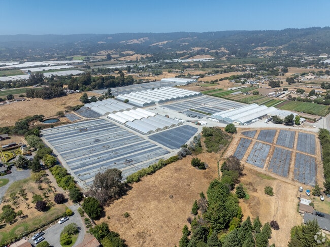

Property Detail
110 Whiting Rd
Horticulturegrowinghousesagricultural
SANTA CRUZ
CA
California
B and X Area of moderate flood hazard, usually the area between the limits of the 100-year and 500-year floods.
18.14 AC
2024
Outlying Santa Cruz Cnty
2025
Santa Cruz/Watsonville
1233001022
Santa Cruz-Watsonville, CA
462,630 SF
051-041-42-000
NEARBY LISTINGS FOR SALE OR LEASE
DEMOGRAPHICS near 110 Whiting Rd
1 mile
3 mile
5 mile
2025 Total Population
629
32,822
69,075
2030 Population
578
31,717
66,678
Pop Growth 2025-2030
(8.11%)
(3.37%)
(3.47%)
Average Age
38
38
37
2025 Total Households
170
9,091
18,512
HH Growth 2025-2030
(9.41%)
(3.85%)
(4.11%)
Median Household Inc
$102,778
$85,440
$82,005
Avg Household Size
3.40
3.40
3.50
2025 Avg HH Vehicles
3.00
2.00
2.00
Median Home Value
$1,051,923
$736,447
$743,814
Median Year Built
1967
1972
1973
Nearby Places
Map Layers
Map Styles
 Street
 Aerial
Layers
 Traffic
 Biking
Places
Listings with unknown addresses are not visible on the map
- Restaurants
- Banks
- Shops
- Fitness
- Groceries
PUBLIC TRANSPORTATION
AIRPORT
Monterey Regional
Drive
Walk
Distance
Monterey Regional
43 min
32.2 mi
Norman Y Mineta San Jose International
Drive
Walk
Distance
Norman Y Mineta San Jose International
68 min
49.3 mi
Freight Ports
Port of Redwood City
Drive
Walk
Distance
Port of Redwood City
88 min
65.2 mi
Nearby Properties
Address
Land Use
TOTAL SIZE
Lot Size
Zoning
Address
Land Use
TOTAL SIZE
Lot Size
Zoning
3,767 SF
6.90 AC
RM-2-R
Address
Land Use
TOTAL SIZE
Lot Size
Zoning
60,392 SF
4.07 AC
RM-4
Address
Land Use
TOTAL SIZE
Lot Size
Zoning
77,449 SF
14.38 AC
R-1-6
Address
Land Use
TOTAL SIZE
Lot Size
Zoning
Address
Land Use
TOTAL SIZE
Lot Size
Zoning
5,963 SF
7.89 AC
Address
Land Use
TOTAL SIZE
Lot Size
Zoning
8.45 AC
Address
Land Use
TOTAL SIZE
Lot Size
Zoning
23,677 SF
67.25 AC
PF
Address
Land Use
TOTAL SIZE
Lot Size
Zoning
59,897 SF
1.54 AC
Address
Land Use
TOTAL SIZE
Lot Size
Zoning
4.59 AC
CA
Address
Land Use
TOTAL SIZE
Lot Size
Zoning
41,700 SF
3 AC
PA
Address
Land Use
TOTAL SIZE
Lot Size
Zoning
58,495 SF
1.77 AC
Address
Land Use
TOTAL SIZE
Lot Size
Zoning
40,585 SF
2.40 AC
R-1-6
Address
Land Use
TOTAL SIZE
Lot Size
Zoning
14.98 AC
PF
Address
Land Use
TOTAL SIZE
Lot Size
Zoning
65,782 SF
3.60 AC
Address
Land Use
TOTAL SIZE
Lot Size
Zoning
75,884 SF
2.03 AC
Address
Land Use
TOTAL SIZE
Lot Size
Zoning
28,611 SF
1.34 AC
R16
Address
Land Use
TOTAL SIZE
Lot Size
Zoning
54,327 SF
1.25 AC
RM4GH
Address
Land Use
TOTAL SIZE
Lot Size
Zoning
27.77 AC
PR
Address
Land Use
TOTAL SIZE
Lot Size
Zoning
85,523 SF
4.36 AC
PF
Address
Land Use
TOTAL SIZE
Lot Size
Zoning
56,387 SF
4.57 AC
RM3
Address
Land Use
TOTAL SIZE
Lot Size
Zoning
62,274 SF
2.24 AC
Address
Land Use
TOTAL SIZE
Lot Size
Zoning
16,722 SF
1.07 AC
PF
Address
Land Use
TOTAL SIZE
Lot Size
Zoning
Address
Land Use
TOTAL SIZE
Lot Size
Zoning
48,055 SF
5.07 AC
A
Address
Land Use
TOTAL SIZE
Lot Size
Zoning
19,634 SF
0.99 AC
Address
Land Use
TOTAL SIZE
Lot Size
Zoning
13.61 AC
CA
Address
Land Use
TOTAL SIZE
Lot Size
Zoning
31,463 SF
2.89 AC
Address
Land Use
TOTAL SIZE
Lot Size
Zoning
79,554 SF
3.09 AC
Address
Land Use
TOTAL SIZE
Lot Size
Zoning
32,808 SF
1.72 AC
The World's #1 Commercial Real Estate Marketplace
Connect with us
© 2026 CoStar Group
The information above has been obtained from sources believed reliable. While we do not doubt its accuracy we have not verified it and make no guarantee, warranty or representation about it. It is your responsibility to independently confirm its accuracy and completeness. Any projections, opinions, assumptions, or estimates used are for example only and do not represent the current or future performance of the property. The value of this transaction to you depends on tax and other factors which should be evaluated by your tax, financial, and legal advisors. You and your advisors should conduct a careful, independent investigation of the property to determine to your satisfaction the suitability of the property for your needs.