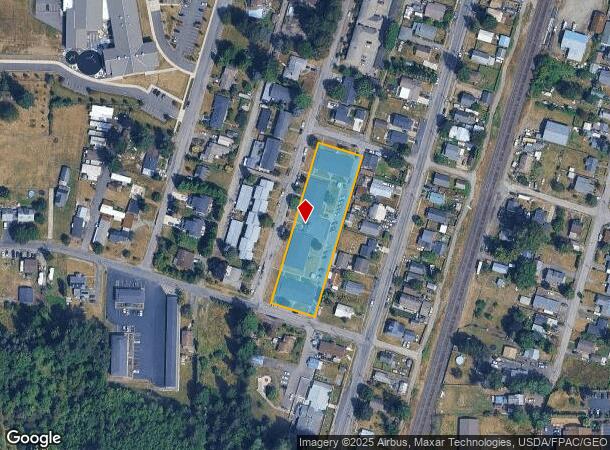
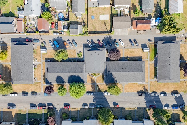
Property Record
1100 S Pearl St, Centralia, WA 98531
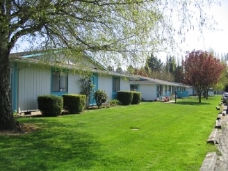
This Property Is For Sale
NEARBY LISTINGS FOR SALE OR LEASE
-
-
View all Centralia listings for sale on LoopNet.com
Property Detail
1100 S Pearl St
Centralia, WA
Rose Galvins Add
001934-014-000
SECTION 17 TOWNSHIP 14N RANGE 02W LOTS 1-15 BLK 2 ROSE GALVINS ADD
Multifamilydwelling
Lewis
ARE
Washington
5301021354C
1-15
2024
1.24 AC
2024
Washington State Area
970700
Other Market Areas
12,000 SF
DEMOGRAPHICS near 1100 S Pearl St
1 Mile
3 Mile
5 Mile
2024 Total Population
5,988
27,170
39,724
2029 Population
6,747
30,481
44,471
Pop Growth 2024-2029
+ 12.68%
+ 12.19%
+ 11.95%
Average Age
37
40
40
2024 Total Households
2,229
10,559
15,258
HH Growth 2024-2029
+ 12.79%
+ 12.29%
+ 12.07%
Median Household Inc
$54,949
$56,909
$61,365
Avg Household Size
2.60
2.50
2.50
2024 Avg HH Vehicles
2.00
2.00
2.00
Median Home Value
$291,428
$296,864
$309,808
Median Year Built
1965
1976
1977
Nearby Places
- Restaurants
- Banks
- Shops
- Fitness
- Groceries
PUBLIC TRANSPORTATION
COMMUTER RAIL
Centralia Amtrak Station (Amtrak Cascades - Amtrak, Coast Starlight - Amtrak)
DRIVE
WALK
Distance
Centralia Amtrak Station (Amtrak Cascades - Amtrak, Coast Starlight - Amtrak)
3 min
20 min
1.0 mi
Freight Ports
Port of Long View, WA
DRIVE
WALK
Distance
Port of Long View, WA
61 min
46.4 mi
Nearby Properties
Address
Land Use
TOTAL SIZE
Lot Size
Zoning
Address
Land Use
TOTAL SIZE
Lot Size
Zoning
2,003 SF
27.85 AC
LBD
Address
Land Use
TOTAL SIZE
Lot Size
Zoning
129,242 SF
11.91 AC
M1
Address
Land Use
TOTAL SIZE
Lot Size
Zoning
Address
Land Use
TOTAL SIZE
Lot Size
Zoning
1,792 SF
38.78 AC
OSPF
Address
Land Use
TOTAL SIZE
Lot Size
Zoning
1,714 SF
220.30 AC
EPFA
Address
Land Use
TOTAL SIZE
Lot Size
Zoning
14,264 SF
6.60 AC
R20
Address
Land Use
TOTAL SIZE
Lot Size
Zoning
222,077 SF
Address
Land Use
TOTAL SIZE
Lot Size
Zoning
2,956 SF
4.99 AC
R15
Address
Land Use
TOTAL SIZE
Lot Size
Zoning
64,421 SF
5 AC
H1
Address
Land Use
TOTAL SIZE
Lot Size
Zoning
7,168 SF
4.10 AC
OSPF
Address
Land Use
TOTAL SIZE
Lot Size
Zoning
43,477 SF
8.64 AC
CG
Address
Land Use
TOTAL SIZE
Lot Size
Zoning
57,621 SF
5.33 AC
H1
Address
Land Use
TOTAL SIZE
Lot Size
Zoning
1.03 AC
C1
Address
Land Use
TOTAL SIZE
Lot Size
Zoning
7,200 SF
4 AC
OSPF
Address
Land Use
TOTAL SIZE
Lot Size
Zoning
29,204 SF
3.91 AC
R20
Address
Land Use
TOTAL SIZE
Lot Size
Zoning
75,993 SF
18.76 AC
PMP
Address
Land Use
TOTAL SIZE
Lot Size
Zoning
34,150 SF
7.20 AC
CG
Address
Land Use
TOTAL SIZE
Lot Size
Zoning
Address
Land Use
TOTAL SIZE
Lot Size
Zoning
Address
Land Use
TOTAL SIZE
Lot Size
Zoning
3,196 SF
4.48 AC
R15
Address
Land Use
TOTAL SIZE
Lot Size
Zoning
48,865 SF
4.70 AC
H1
Address
Land Use
TOTAL SIZE
Lot Size
Zoning
104,872 SF
Address
Land Use
TOTAL SIZE
Lot Size
Zoning
94,044 SF
Address
Land Use
TOTAL SIZE
Lot Size
Zoning
Address
Land Use
TOTAL SIZE
Lot Size
Zoning
3,536 SF
1.73 AC
R20
Address
Land Use
TOTAL SIZE
Lot Size
Zoning
83,043 SF
6.76 AC
CG
Address
Land Use
TOTAL SIZE
Lot Size
Zoning
1,512 SF
8.64 AC
OSPF
Address
Land Use
TOTAL SIZE
Lot Size
Zoning
21,672 SF
2.08 AC
R20
Address
Land Use
TOTAL SIZE
Lot Size
Zoning
864 SF
45.31 AC
OSPF
Address
Land Use
TOTAL SIZE
Lot Size
Zoning
34,408 SF
3.58 AC
C1
The World's #1 Commercial Real Estate Marketplace
Connect with us
© 2025 CoStar Group
The information above has been obtained from sources believed reliable. While we do not doubt its accuracy we have not verified it and make no guarantee, warranty or representation about it. It is your responsibility to independently confirm its accuracy and completeness. Any projections, opinions, assumptions, or estimates used are for example only and do not represent the current or future performance of the property. The value of this transaction to you depends on tax and other factors which should be evaluated by your tax, financial, and legal advisors. You and your advisors should conduct a careful, independent investigation of the property to determine to your satisfaction the suitability of the property for your needs.