No Photo
Property Record
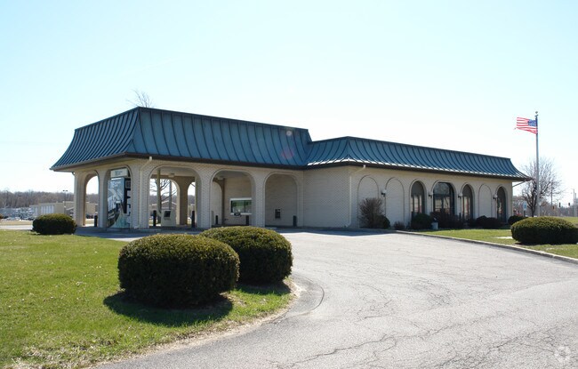
1100 17Th St, Silvis, IL 61282


NEARBY LISTINGS FOR SALE OR LEASE
-
-
View all Silvis listings for sale on LoopNet.com
Property Detail
1100 17Th St
18-05-100-015
SUPVR ASST MAP LOT 120 SHEET 7
Commercialnec
Rock Island
X
Illinois
17073C0135E
120
2024
2.01 AC
2024
Outlying Rock Island Cnty
020301
Davenport/Moline/Rock Island
3,074 SF
Davenport-Moline-Rock Island, IA-IL
DEMOGRAPHICS near 1100 17Th St
1 mile
3 mile
5 mile
2024 Total Population
7,349
34,993
70,543
2029 Population
7,202
34,176
68,890
Pop Growth 2024-2029
(2.00%)
(2.33%)
(2.34%)
Average Age
42
41
42
2024 Total Households
3,247
14,900
29,500
HH Growth 2024-2029
(1.94%)
(2.40%)
(2.40%)
Median Household Inc
$60,020
$57,242
$61,590
Avg Household Size
2.20
2.30
2.30
2024 Avg HH Vehicles
2.00
2.00
2.00
Median Home Value
$143,719
$137,245
$151,701
Median Year Built
1980
1967
1966
Nearby Places
Map Layers
Map Styles
 Street
 Aerial
Transit
 Traffic
 Biking
Places
Listings with unknown addresses are not visible on the map
- Restaurants
- Banks
- Shops
- Fitness
- Groceries
PUBLIC TRANSPORTATION
AIRPORT
Quad Cities International
Drive
Walk
Distance
Quad Cities International
17 min
8.5 mi
Nearby Properties
Address
Land Use
TOTAL SIZE
Lot Size
Zoning
Address
Land Use
TOTAL SIZE
Lot Size
Zoning
333.38 AC
B3
Address
Land Use
TOTAL SIZE
Lot Size
Zoning
3,384,969 SF
128 AC
EM
Address
Land Use
TOTAL SIZE
Lot Size
Zoning
122,298 SF
65.13 AC
EM
Address
Land Use
TOTAL SIZE
Lot Size
Zoning
197,382 SF
14.06 AC
EM
Address
Land Use
TOTAL SIZE
Lot Size
Zoning
112,000 SF
16.50 AC
EM
Address
Land Use
TOTAL SIZE
Lot Size
Zoning
166,102 SF
4.36 AC
SIL
Address
Land Use
TOTAL SIZE
Lot Size
Zoning
333,348 SF
30.81 AC
EM
Address
Land Use
TOTAL SIZE
Lot Size
Zoning
132,647 SF
13.76 AC
MOL
Address
Land Use
TOTAL SIZE
Lot Size
Zoning
196,305 SF
24.75 AC
SIL
Address
Land Use
TOTAL SIZE
Lot Size
Zoning
253.10 AC
SIL
Address
Land Use
TOTAL SIZE
Lot Size
Zoning
Address
Land Use
TOTAL SIZE
Lot Size
Zoning
244,440 SF
13.25 AC
MOL
Address
Land Use
TOTAL SIZE
Lot Size
Zoning
46,917 SF
4.57 AC
SIL
Address
Land Use
TOTAL SIZE
Lot Size
Zoning
203,904 SF
12.75 AC
MOL
Address
Land Use
TOTAL SIZE
Lot Size
Zoning
18.46 AC
EM
Address
Land Use
TOTAL SIZE
Lot Size
Zoning
103,360 SF
14.66 AC
EM
Address
Land Use
TOTAL SIZE
Lot Size
Zoning
45,000 SF
2.52 AC
SIL
Address
Land Use
TOTAL SIZE
Lot Size
Zoning
134,142 SF
13.31 AC
EM
Address
Land Use
TOTAL SIZE
Lot Size
Zoning
3.12 AC
SIL
Address
Land Use
TOTAL SIZE
Lot Size
Zoning
144,306 SF
16.90 AC
EM
Address
Land Use
TOTAL SIZE
Lot Size
Zoning
30,836 SF
4.91 AC
MOL
Address
Land Use
TOTAL SIZE
Lot Size
Zoning
433,640 SF
32.30 AC
EM
Address
Land Use
TOTAL SIZE
Lot Size
Zoning
218,640 SF
9.97 AC
EM
Address
Land Use
TOTAL SIZE
Lot Size
Zoning
107,880 SF
1.79 AC
EM
Address
Land Use
TOTAL SIZE
Lot Size
Zoning
5.26 AC
Address
Land Use
TOTAL SIZE
Lot Size
Zoning
81,027 SF
6.57 AC
SIL
Address
Land Use
TOTAL SIZE
Lot Size
Zoning
64,800 SF
97.96 AC
EM
Address
Land Use
TOTAL SIZE
Lot Size
Zoning
130,200 SF
3 AC
EM
Address
Land Use
TOTAL SIZE
Lot Size
Zoning
Address
Land Use
TOTAL SIZE
Lot Size
Zoning
35,631 SF
4.63 AC
MOL
The World's #1 Commercial Real Estate Marketplace
Connect with us
© 2026 CoStar Group
The information above has been obtained from sources believed reliable. While we do not doubt its accuracy we have not verified it and make no guarantee, warranty or representation about it. It is your responsibility to independently confirm its accuracy and completeness. Any projections, opinions, assumptions, or estimates used are for example only and do not represent the current or future performance of the property. The value of this transaction to you depends on tax and other factors which should be evaluated by your tax, financial, and legal advisors. You and your advisors should conduct a careful, independent investigation of the property to determine to your satisfaction the suitability of the property for your needs.