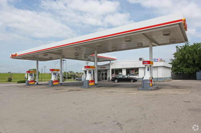
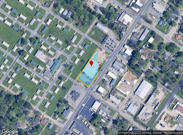
Property Record
1100 4Th Ave N, Bessemer, AL 35020

NEARBY LISTINGS FOR SALE OR LEASE
Property Detail
1100 4Th Ave N
Birmingham-Hoover, AL
Elyton Land Companys Survey
38-00-09-3-017-006.000
BEGIN AT THE S E COR OF LOT SAID PT BEING THE N W INTER OF 4TH AVE & 11TH ST TH NELY 175 FT S ALONG N W R/W OF 4TH AVE TO A PT ON THE E LINE OF THE S W 1/4 SEC 9 T 19 S R 4 W TH N 275 FT S ALONG E LINE OF S W 1/4 TO A PT ON THE S W R/W OF 12TH ST N T
Uspostalservice
Jefferson
AE
Alabama
01073C0539G
said
0
1.01 AC
2024
CBD
010200
Birmingham
18,954 SF
DEMOGRAPHICS near 1100 4Th Ave N
1 Mile
3 Mile
5 Mile
2024 Total Population
7,405
82,770
175,157
2029 Population
7,663
83,469
175,054
Pop Growth 2024-2029
+ 3.48%
+ 0.84%
(0.06%)
Average Age
36
38
39
2024 Total Households
4,143
38,681
76,301
HH Growth 2024-2029
+ 3.55%
+ 0.96%
+ 0.01%
Median Household Inc
$34,757
$37,946
$43,095
Avg Household Size
1.70
1.90
2.10
2024 Avg HH Vehicles
1.00
1.00
2.00
Median Home Value
$193,981
$178,376
$196,147
Median Year Built
1992
1966
1964
Nearby Places
Map Layers
Map Styles
 Street
 Aerial
- Restaurants
- Banks
- Shops
- Fitness
- Groceries
PUBLIC TRANSPORTATION
AIRPORT
Birmingham-Shuttlesworth International
DRIVE
WALK
Distance
Birmingham-Shuttlesworth International
27 min
20.8 mi
Freight Ports
Port of Mobile
DRIVE
WALK
Distance
Port of Mobile
281 min
238.2 mi
Nearby Properties
Address
Land Use
TOTAL SIZE
Lot Size
Zoning
Address
Land Use
TOTAL SIZE
Lot Size
Zoning
857,420 SF
34.50 AC
I3
Address
Land Use
TOTAL SIZE
Lot Size
Zoning
106 AC
I3
Address
Land Use
TOTAL SIZE
Lot Size
Zoning
929,435 SF
58 AC
I4
Address
Land Use
TOTAL SIZE
Lot Size
Zoning
184,428 SF
9.70 AC
01
Address
Land Use
TOTAL SIZE
Lot Size
Zoning
75,840 SF
20.10 AC
I3
Address
Land Use
TOTAL SIZE
Lot Size
Zoning
311,900 SF
30.20 AC
Address
Land Use
TOTAL SIZE
Lot Size
Zoning
210,815 SF
114 AC
I1-A
Address
Land Use
TOTAL SIZE
Lot Size
Zoning
47,705 SF
0.69 AC
01
Address
Land Use
TOTAL SIZE
Lot Size
Zoning
113,220 SF
22.60 AC
I3
Address
Land Use
TOTAL SIZE
Lot Size
Zoning
187,200 SF
22 AC
I3
Address
Land Use
TOTAL SIZE
Lot Size
Zoning
553,137 SF
87 AC
I2
Address
Land Use
TOTAL SIZE
Lot Size
Zoning
195,461 SF
15.03 AC
C3-R
Address
Land Use
TOTAL SIZE
Lot Size
Zoning
38,868 SF
10.90 AC
C-4
Address
Land Use
TOTAL SIZE
Lot Size
Zoning
136,115 SF
14.90 AC
C3
Address
Land Use
TOTAL SIZE
Lot Size
Zoning
145,300 SF
25 AC
R3
Address
Land Use
TOTAL SIZE
Lot Size
Zoning
122,720 SF
6.77 AC
O1-R
Address
Land Use
TOTAL SIZE
Lot Size
Zoning
137,641 SF
26.80 AC
R4
Address
Land Use
TOTAL SIZE
Lot Size
Zoning
132,116 SF
9.15 AC
R3
Address
Land Use
TOTAL SIZE
Lot Size
Zoning
230,088 SF
I3
Address
Land Use
TOTAL SIZE
Lot Size
Zoning
63.30 AC
I3
Address
Land Use
TOTAL SIZE
Lot Size
Zoning
77,902 SF
44 AC
I3
Address
Land Use
TOTAL SIZE
Lot Size
Zoning
1,090,237 SF
28.10 AC
I4
Address
Land Use
TOTAL SIZE
Lot Size
Zoning
66,900 SF
3.78 AC
I4
Address
Land Use
TOTAL SIZE
Lot Size
Zoning
38,376 SF
4.87 AC
C3
Address
Land Use
TOTAL SIZE
Lot Size
Zoning
45,959 SF
6.72 AC
C-4
Address
Land Use
TOTAL SIZE
Lot Size
Zoning
366,421 SF
21 AC
I3
Address
Land Use
TOTAL SIZE
Lot Size
Zoning
3.29 AC
O1
Address
Land Use
TOTAL SIZE
Lot Size
Zoning
163,056 SF
I-3
Address
Land Use
TOTAL SIZE
Lot Size
Zoning
81,846 SF
77.30 AC
I3
Address
Land Use
TOTAL SIZE
Lot Size
Zoning
28,722 SF
2.90 AC
A-1
The World's #1 Commercial Real Estate Marketplace
Connect with us
© 2025 CoStar Group
The information above has been obtained from sources believed reliable. While we do not doubt its accuracy we have not verified it and make no guarantee, warranty or representation about it. It is your responsibility to independently confirm its accuracy and completeness. Any projections, opinions, assumptions, or estimates used are for example only and do not represent the current or future performance of the property. The value of this transaction to you depends on tax and other factors which should be evaluated by your tax, financial, and legal advisors. You and your advisors should conduct a careful, independent investigation of the property to determine to your satisfaction the suitability of the property for your needs.