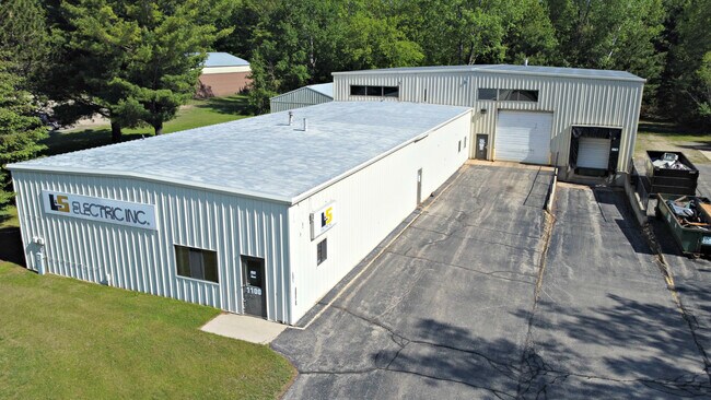
Property Record
1100 56Th Ave, Menominee, MI 49858

NEARBY LISTINGS FOR SALE OR LEASE
-
-
View all Menominee listings for sale on LoopNet.com
Property Detail
1100 56Th Ave
051-040-230-00
SEC 22 T32N R27W COM AT E 1/4 COR; TH N 03 35' 35 W 505.49'; TH S 86 41' 02 W 295.99'' TO POB; TH S 86 41' 02 W 188'; T
Industrialgeneral
Menominee
X
Michigan
26109C0738E
1.80 AC
2025
Upper Peninsula
2025
Other Market Areas
960500
Marinette, WI-MI
10,000 SF
DEMOGRAPHICS near 1100 56Th Ave
1 Mile
3 Mile
5 Mile
2024 Total Population
1,175
8,156
22,625
2029 Population
1,119
8,054
22,891
Pop Growth 2024-2029
(4.77%)
(1.25%)
+ 1.18%
Average Age
46
44
43
2024 Total Households
561
3,903
10,450
HH Growth 2024-2029
(4.81%)
(1.20%)
+ 1.19%
Median Household Inc
$44,374
$52,328
$53,084
Avg Household Size
2.10
2.10
2.10
2024 Avg HH Vehicles
2.00
2.00
2.00
Median Home Value
$129,042
$101,509
$101,882
Median Year Built
1972
1959
1967
Nearby Places
Map Layers
Map Styles
 Street
 Aerial
- Restaurants
- Banks
- Shops
- Fitness
- Groceries
SALE & LEASE HISTORY
LISTING DATE
SALE/LEASE

Jun 15, 2021
For Sale
Nearby Properties
Address
Land Use
TOTAL SIZE
Lot Size
Zoning
Address
Land Use
TOTAL SIZE
Lot Size
Zoning
265,051 SF
13.99 AC
R1
Address
Land Use
TOTAL SIZE
Lot Size
Zoning
81,588 SF
Address
Land Use
TOTAL SIZE
Lot Size
Zoning
111,456 SF
7.42 AC
R1
Address
Land Use
TOTAL SIZE
Lot Size
Zoning
44,813 SF
Address
Land Use
TOTAL SIZE
Lot Size
Zoning
390 SF
479 AC
Address
Land Use
TOTAL SIZE
Lot Size
Zoning
25,210 SF
200 AC
Address
Land Use
TOTAL SIZE
Lot Size
Zoning
80,000 SF
Address
Land Use
TOTAL SIZE
Lot Size
Zoning
19,316 SF
3.48 AC
R1
Address
Land Use
TOTAL SIZE
Lot Size
Zoning
92,864 SF
10.33 AC
M1
Address
Land Use
TOTAL SIZE
Lot Size
Zoning
197.79 AC
Address
Land Use
TOTAL SIZE
Lot Size
Zoning
150,292 SF
R1
Address
Land Use
TOTAL SIZE
Lot Size
Zoning
62,480 SF
3.15 AC
Address
Land Use
TOTAL SIZE
Lot Size
Zoning
60,960 SF
6.42 AC
R1
Address
Land Use
TOTAL SIZE
Lot Size
Zoning
19,508 SF
1.59 AC
R1
Address
Land Use
TOTAL SIZE
Lot Size
Zoning
151.24 AC
Address
Land Use
TOTAL SIZE
Lot Size
Zoning
37,903 SF
1.80 AC
R1
Address
Land Use
TOTAL SIZE
Lot Size
Zoning
4,568 SF
1.29 AC
Address
Land Use
TOTAL SIZE
Lot Size
Zoning
30,656 SF
1.54 AC
R1
Address
Land Use
TOTAL SIZE
Lot Size
Zoning
17,338 SF
1.55 AC
R1
Address
Land Use
TOTAL SIZE
Lot Size
Zoning
103,853 SF
10.16 AC
Address
Land Use
TOTAL SIZE
Lot Size
Zoning
4,800 SF
1.20 AC
Address
Land Use
TOTAL SIZE
Lot Size
Zoning
23,816 SF
2.11 AC
R1
Address
Land Use
TOTAL SIZE
Lot Size
Zoning
196,925 SF
14.85 AC
R1
Address
Land Use
TOTAL SIZE
Lot Size
Zoning
105,306 SF
5.66 AC
R1
Address
Land Use
TOTAL SIZE
Lot Size
Zoning
5,931 SF
1.81 AC
R1
Address
Land Use
TOTAL SIZE
Lot Size
Zoning
4,300 SF
1.10 AC
R1
Address
Land Use
TOTAL SIZE
Lot Size
Zoning
8,048 SF
0.75 AC
R1
Address
Land Use
TOTAL SIZE
Lot Size
Zoning
19,228 SF
1.55 AC
R1
Address
Land Use
TOTAL SIZE
Lot Size
Zoning
1,488 SF
6.67 AC
R1
Address
Land Use
TOTAL SIZE
Lot Size
Zoning
12,000 SF
0.96 AC
The World's #1 Commercial Real Estate Marketplace
Connect with us
© 2025 CoStar Group
The information above has been obtained from sources believed reliable. While we do not doubt its accuracy we have not verified it and make no guarantee, warranty or representation about it. It is your responsibility to independently confirm its accuracy and completeness. Any projections, opinions, assumptions, or estimates used are for example only and do not represent the current or future performance of the property. The value of this transaction to you depends on tax and other factors which should be evaluated by your tax, financial, and legal advisors. You and your advisors should conduct a careful, independent investigation of the property to determine to your satisfaction the suitability of the property for your needs.