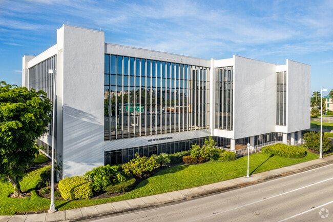
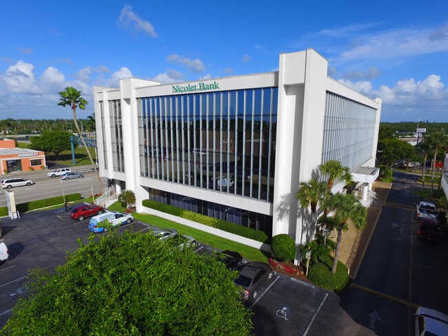
Property Record
1100 5Th Ave S, Naples, FL 34102

Current Lease Availabilities
NEARBY LISTINGS FOR SALE OR LEASE
Property Detail
1100 5Th Ave S
Naples-Immokalee-Marco Island, FL
Seaboard Replat Of Naples
19016080005
SEABOARD REPLAT T 12 BLK 15 LTS 1-13 & W 40FT OF E 100FT OF SW 1/4 OF SEC 3 LYING BE- TWEEN S LI OF US 41 & N LI OF 6TH AVE S & VACATED E/W ALLEY, LESS R/W FOR SR 90 IN NE CNR OF UN-NUMBERED TRACT AS DESC IN OR 2107 PG 1779-81
Officebuilding
Collier
AE
Florida
12021C0393J
1
2024
1.56 AC
2025
Naples
000101
Southwest Florida
25,311 SF
DEMOGRAPHICS near 1100 5Th Ave S
1 Mile
3 Mile
5 Mile
2024 Total Population
8,982
41,923
103,602
2029 Population
10,657
48,505
119,647
Pop Growth 2024-2029
+ 18.65%
+ 15.70%
+ 15.49%
Average Age
56
52
53
2024 Total Households
4,590
19,449
48,725
HH Growth 2024-2029
+ 18.80%
+ 15.66%
+ 15.41%
Median Household Inc
$66,482
$67,962
$72,884
Avg Household Size
1.90
2.00
2.00
2024 Avg HH Vehicles
1.00
2.00
2.00
Median Home Value
$895,565
$474,438
$411,126
Median Year Built
1988
1983
1988
Nearby Places
Map Layers
Map Styles
 Street
 Aerial
- Restaurants
- Banks
- Shops
- Fitness
- Groceries
PUBLIC TRANSPORTATION
AIRPORT
Southwest Florida International
DRIVE
WALK
Distance
Southwest Florida International
49 min
35.7 mi
Nearby Properties
Address
Land Use
TOTAL SIZE
Lot Size
Zoning
Address
Land Use
TOTAL SIZE
Lot Size
Zoning
1,429,641 SF
45.28 AC
P
Address
Land Use
TOTAL SIZE
Lot Size
Zoning
556,070 SF
13.72 AC
NAPLES
Address
Land Use
TOTAL SIZE
Lot Size
Zoning
Address
Land Use
TOTAL SIZE
Lot Size
Zoning
1,850 SF
5.20 AC
Address
Land Use
TOTAL SIZE
Lot Size
Zoning
560,854 SF
592.62 AC
NAPLES
Address
Land Use
TOTAL SIZE
Lot Size
Zoning
2,440 SF
3.99 AC
NAPLES
Address
Land Use
TOTAL SIZE
Lot Size
Zoning
77,529 SF
1.15 AC
NAPLES
Address
Land Use
TOTAL SIZE
Lot Size
Zoning
250,674 SF
33.61 AC
NAPLES
Address
Land Use
TOTAL SIZE
Lot Size
Zoning
362,032 SF
15.97 AC
PUD
Address
Land Use
TOTAL SIZE
Lot Size
Zoning
936 SF
2.47 AC
Address
Land Use
TOTAL SIZE
Lot Size
Zoning
140,512 SF
12.10 AC
PUD
Address
Land Use
TOTAL SIZE
Lot Size
Zoning
26,296 SF
2.10 AC
Address
Land Use
TOTAL SIZE
Lot Size
Zoning
291,699 SF
18.17 AC
PUD
Address
Land Use
TOTAL SIZE
Lot Size
Zoning
932,389 SF
36.28 AC
NAPLES
Address
Land Use
TOTAL SIZE
Lot Size
Zoning
131,210 SF
3.62 AC
Address
Land Use
TOTAL SIZE
Lot Size
Zoning
137,799 SF
5.78 AC
Address
Land Use
TOTAL SIZE
Lot Size
Zoning
159,901 SF
10.08 AC
RMF-16
Address
Land Use
TOTAL SIZE
Lot Size
Zoning
93,542 SF
4.09 AC
NAPLES
Address
Land Use
TOTAL SIZE
Lot Size
Zoning
39,546 SF
1.62 AC
Address
Land Use
TOTAL SIZE
Lot Size
Zoning
71,516 SF
2.88 AC
NAPLES
Address
Land Use
TOTAL SIZE
Lot Size
Zoning
217,119 SF
4.20 AC
NAPLES
Address
Land Use
TOTAL SIZE
Lot Size
Zoning
61,910 SF
45.05 AC
A
Address
Land Use
TOTAL SIZE
Lot Size
Zoning
69,767 SF
1.89 AC
NAPLES
Address
Land Use
TOTAL SIZE
Lot Size
Zoning
70,944 SF
9.51 AC
P
Address
Land Use
TOTAL SIZE
Lot Size
Zoning
203,171 SF
16.64 AC
NAPLES
Address
Land Use
TOTAL SIZE
Lot Size
Zoning
168,247 SF
25.60 AC
RMF-6
Address
Land Use
TOTAL SIZE
Lot Size
Zoning
19,641 SF
2.93 AC
NAPLES
Address
Land Use
TOTAL SIZE
Lot Size
Zoning
1,388 SF
6.89 AC
NAPLES
Address
Land Use
TOTAL SIZE
Lot Size
Zoning
240,746 SF
30.45 AC
PUD
Address
Land Use
TOTAL SIZE
Lot Size
Zoning
49,687 SF
3.16 AC
NAPLES
The World's #1 Commercial Real Estate Marketplace
Connect with us
© 2025 CoStar Group
The information above has been obtained from sources believed reliable. While we do not doubt its accuracy we have not verified it and make no guarantee, warranty or representation about it. It is your responsibility to independently confirm its accuracy and completeness. Any projections, opinions, assumptions, or estimates used are for example only and do not represent the current or future performance of the property. The value of this transaction to you depends on tax and other factors which should be evaluated by your tax, financial, and legal advisors. You and your advisors should conduct a careful, independent investigation of the property to determine to your satisfaction the suitability of the property for your needs.