Property Record
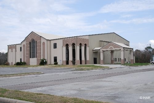
1100 Dell Dale St, Channelview, TX 77530

Property Detail
1100 Dell Dale St
1237980010001
RES A BLK 1 PRAISE CHRISTIAN CENTER
Religious
HARRIS
B and X Area of moderate flood hazard, usually the area between the limits of the 100-year and 500-year floods.
Texas
2024
6.78 AC
2025
I-10 East
252306
Houston
30,359 SF
Houston-Pasadena-The Woodlands, TX
NEARBY LISTINGS FOR SALE OR LEASE
-
-
View all Channelview listings for sale on LoopNet.com
DEMOGRAPHICS near 1100 Dell Dale St
1 mile
3 mile
5 mile
2025 Total Population
21,028
87,776
141,366
2030 Population
22,176
92,843
149,909
Pop Growth 2025-2030
+ 5.46%
+ 5.77%
+ 6.04%
Average Age
34
34
35
2025 Total Households
6,161
26,412
43,638
HH Growth 2025-2030
+ 5.60%
+ 5.91%
+ 6.21%
Median Household Inc
$70,999
$63,416
$62,607
Avg Household Size
3.40
3.20
3.20
2025 Avg HH Vehicles
2.00
2.00
2.00
Median Home Value
$215,273
$210,869
$208,214
Median Year Built
1988
1986
1985
Nearby Places
Map Layers
Map Styles
 Street
 Aerial
Layers
 Traffic
 Biking
Places
Listings with unknown addresses are not visible on the map
- Restaurants
- Banks
- Shops
- Fitness
- Groceries
PUBLIC TRANSPORTATION
AIRPORT
William P Hobby
Drive
Walk
Distance
William P Hobby
36 min
21.0 mi
George Bush Intcntl/Houston
Drive
Walk
Distance
George Bush Intcntl/Houston
29 min
23.1 mi
Freight Ports
Port of Houston
Drive
Walk
Distance
Port of Houston
23 min
13.0 mi
Nearby Properties
Address
Land Use
TOTAL SIZE
Lot Size
Zoning
Address
Land Use
TOTAL SIZE
Lot Size
Zoning
Address
Land Use
TOTAL SIZE
Lot Size
Zoning
330.90 AC
Address
Land Use
TOTAL SIZE
Lot Size
Zoning
10,093,711 SF
30.83 AC
Address
Land Use
TOTAL SIZE
Lot Size
Zoning
409.44 AC
Address
Land Use
TOTAL SIZE
Lot Size
Zoning
1,056.36 AC
Address
Land Use
TOTAL SIZE
Lot Size
Zoning
183.58 AC
Address
Land Use
TOTAL SIZE
Lot Size
Zoning
2,936,644 SF
59.90 AC
Address
Land Use
TOTAL SIZE
Lot Size
Zoning
315.64 AC
Address
Land Use
TOTAL SIZE
Lot Size
Zoning
1,403,952 SF
48.81 AC
Address
Land Use
TOTAL SIZE
Lot Size
Zoning
338.08 AC
Address
Land Use
TOTAL SIZE
Lot Size
Zoning
760,851 SF
41.87 AC
Address
Land Use
TOTAL SIZE
Lot Size
Zoning
59.10 AC
Address
Land Use
TOTAL SIZE
Lot Size
Zoning
30.84 AC
Address
Land Use
TOTAL SIZE
Lot Size
Zoning
398,995 SF
27.39 AC
Address
Land Use
TOTAL SIZE
Lot Size
Zoning
271,428 SF
10.57 AC
Address
Land Use
TOTAL SIZE
Lot Size
Zoning
202,544 SF
4.06 AC
Address
Land Use
TOTAL SIZE
Lot Size
Zoning
485,662 SF
48.80 AC
Address
Land Use
TOTAL SIZE
Lot Size
Zoning
248,293 SF
13.20 AC
Address
Land Use
TOTAL SIZE
Lot Size
Zoning
526,975 SF
21.08 AC
Address
Land Use
TOTAL SIZE
Lot Size
Zoning
195,732 SF
19.50 AC
Address
Land Use
TOTAL SIZE
Lot Size
Zoning
315.64 AC
Address
Land Use
TOTAL SIZE
Lot Size
Zoning
205,001 SF
16.63 AC
Address
Land Use
TOTAL SIZE
Lot Size
Zoning
392.95 AC
Address
Land Use
TOTAL SIZE
Lot Size
Zoning
537,768 SF
12.46 AC
Address
Land Use
TOTAL SIZE
Lot Size
Zoning
197,953 SF
8.29 AC
Address
Land Use
TOTAL SIZE
Lot Size
Zoning
48.81 AC
Address
Land Use
TOTAL SIZE
Lot Size
Zoning
174,606 SF
55.34 AC
Address
Land Use
TOTAL SIZE
Lot Size
Zoning
202,747 SF
15.93 AC
Address
Land Use
TOTAL SIZE
Lot Size
Zoning
296,173 SF
16.33 AC
Address
Land Use
TOTAL SIZE
Lot Size
Zoning
198,265 SF
9.59 AC
The World's #1 Commercial Real Estate Marketplace
Connect with us
© 2026 CoStar Group
The information above has been obtained from sources believed reliable. While we do not doubt its accuracy we have not verified it and make no guarantee, warranty or representation about it. It is your responsibility to independently confirm its accuracy and completeness. Any projections, opinions, assumptions, or estimates used are for example only and do not represent the current or future performance of the property. The value of this transaction to you depends on tax and other factors which should be evaluated by your tax, financial, and legal advisors. You and your advisors should conduct a careful, independent investigation of the property to determine to your satisfaction the suitability of the property for your needs.