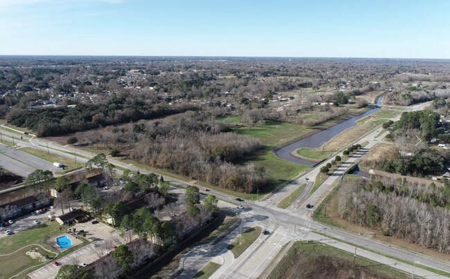
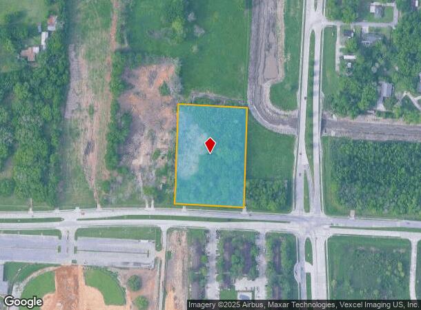
Property Record
1100 E Blk E Pont Des Mouton Rd, Lafayette, LA 70507
NEARBY LISTINGS FOR SALE OR LEASE
Property Detail
1100 E Blk E Pont Des Mouton Rd
Lafayette, LA
Mouton Bridge Subdivision
6059272
PART LOT 1 MOUTON BRIDGE SUBD (3.78 AC MORE OR LESS)
Institutionalvacantland
Lafayette
AE
Louisiana
22055C0100J
1
2024
3.78 AC
2024
Greater Lafayette
001001
Lafayette
DEMOGRAPHICS near 1100 E Blk E Pont Des Mouton Rd
1 Mile
3 Mile
5 Mile
2024 Total Population
3,293
31,738
73,499
2029 Population
3,432
33,881
77,944
Pop Growth 2024-2029
+ 4.22%
+ 6.75%
+ 6.05%
Average Age
41
39
39
2024 Total Households
1,303
12,544
29,742
HH Growth 2024-2029
+ 4.14%
+ 6.73%
+ 6.07%
Median Household Inc
$60,079
$43,156
$40,988
Avg Household Size
2.40
2.40
2.30
2024 Avg HH Vehicles
2.00
2.00
1.00
Median Home Value
$155,861
$143,290
$151,194
Median Year Built
1978
1978
1977
Nearby Places
Map Layers
Map Styles
 Street
 Aerial
- Restaurants
- Banks
- Shops
- Fitness
- Groceries
PUBLIC TRANSPORTATION
COMMUTER RAIL
Lafayette Amtrak Station (Sunset Limited - Amtrak)
DRIVE
WALK
Distance
Lafayette Amtrak Station (Sunset Limited - Amtrak)
8 min
4.8 mi
AIRPORT
Lafayette Regional/Paul Fournet Field
DRIVE
WALK
Distance
Lafayette Regional/Paul Fournet Field
11 min
5.7 mi
Freight Ports
Port of Iberia
DRIVE
WALK
Distance
Port of Iberia
38 min
27.8 mi
SALE & LEASE HISTORY
LISTING DATE
SALE/LEASE

Aug 02, 2024
For Lease
Aug 02, 2024
For Sale
Nearby Properties
Address
Land Use
TOTAL SIZE
Lot Size
Zoning
Address
Land Use
TOTAL SIZE
Lot Size
Zoning
181,875 SF
50.80 AC
Address
Land Use
TOTAL SIZE
Lot Size
Zoning
25.22 AC
Address
Land Use
TOTAL SIZE
Lot Size
Zoning
182,700 SF
25.62 AC
Address
Land Use
TOTAL SIZE
Lot Size
Zoning
132,882 SF
13.98 AC
Address
Land Use
TOTAL SIZE
Lot Size
Zoning
423,600 SF
24.16 AC
Address
Land Use
TOTAL SIZE
Lot Size
Zoning
84,009 SF
6.90 AC
Address
Land Use
TOTAL SIZE
Lot Size
Zoning
203,442 SF
39.38 AC
Address
Land Use
TOTAL SIZE
Lot Size
Zoning
15,138 SF
18.57 AC
Address
Land Use
TOTAL SIZE
Lot Size
Zoning
Address
Land Use
TOTAL SIZE
Lot Size
Zoning
24.08 AC
Address
Land Use
TOTAL SIZE
Lot Size
Zoning
69,500 SF
29.03 AC
Address
Land Use
TOTAL SIZE
Lot Size
Zoning
22,335 SF
30.61 AC
Address
Land Use
TOTAL SIZE
Lot Size
Zoning
58,359 SF
21.04 AC
Address
Land Use
TOTAL SIZE
Lot Size
Zoning
78,612 SF
5.84 AC
Address
Land Use
TOTAL SIZE
Lot Size
Zoning
9.75 AC
Address
Land Use
TOTAL SIZE
Lot Size
Zoning
13.67 AC
Address
Land Use
TOTAL SIZE
Lot Size
Zoning
116,010 SF
25.46 AC
Address
Land Use
TOTAL SIZE
Lot Size
Zoning
26,637 SF
11 AC
Address
Land Use
TOTAL SIZE
Lot Size
Zoning
135,723 SF
16.14 AC
Address
Land Use
TOTAL SIZE
Lot Size
Zoning
69,805 SF
6.26 AC
Address
Land Use
TOTAL SIZE
Lot Size
Zoning
81,871 SF
7.23 AC
Address
Land Use
TOTAL SIZE
Lot Size
Zoning
7.78 AC
Address
Land Use
TOTAL SIZE
Lot Size
Zoning
126,772 SF
10.34 AC
Address
Land Use
TOTAL SIZE
Lot Size
Zoning
98,007 SF
16.14 AC
Address
Land Use
TOTAL SIZE
Lot Size
Zoning
203,482 SF
21.46 AC
Address
Land Use
TOTAL SIZE
Lot Size
Zoning
147,000 SF
14.78 AC
Address
Land Use
TOTAL SIZE
Lot Size
Zoning
4.35 AC
Address
Land Use
TOTAL SIZE
Lot Size
Zoning
45,812 SF
4.88 AC
Address
Land Use
TOTAL SIZE
Lot Size
Zoning
28,305 SF
13.16 AC
Address
Land Use
TOTAL SIZE
Lot Size
Zoning
104,276 SF
8.07 AC
The World's #1 Commercial Real Estate Marketplace
Connect with us
© 2025 CoStar Group
The information above has been obtained from sources believed reliable. While we do not doubt its accuracy we have not verified it and make no guarantee, warranty or representation about it. It is your responsibility to independently confirm its accuracy and completeness. Any projections, opinions, assumptions, or estimates used are for example only and do not represent the current or future performance of the property. The value of this transaction to you depends on tax and other factors which should be evaluated by your tax, financial, and legal advisors. You and your advisors should conduct a careful, independent investigation of the property to determine to your satisfaction the suitability of the property for your needs.