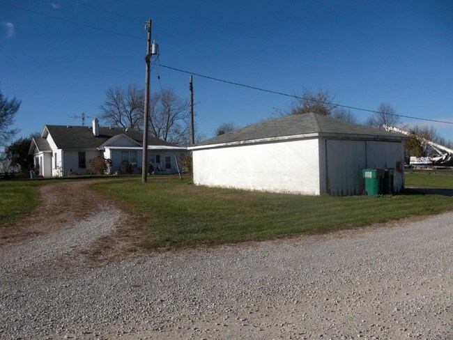
Property Record
1100 E Main Street Ext, Georgetown, KY 40324


Save to a Folder
{{folder.Name}}
{{folder.ListingIds.length}} Properties
{{folder.ListingIds.length}} Property
Create a New Folder
Property Detail
1100 E Main Street Ext
Lexington-Fayette, KY
FARM
191-10-019.000
Scott
Taxexempt
Kentucky
AE The base floodplain where base flood elevations are provided. AE Zones are now used on new format FIRMs instead of A1-A30 Zones.
p1,t,1
0
27.52 AC
2025
Scott County
040301
Lexington/Fayette
1,664 SF
NEARBY LISTINGS FOR SALE OR LEASE
DEMOGRAPHICS near 1100 E Main Street Ext
1 mile
3 mile
5 mile
2025 Total Population
6,798
37,078
46,686
2030 Population
7,200
39,418
49,639
Pop Growth 2025-2030
+ 5.91%
+ 6.31%
+ 6.33%
Average Age
33
36
37
2025 Total Households
2,525
14,178
17,625
HH Growth 2025-2030
+ 6.06%
+ 6.52%
+ 6.56%
Median Household Inc
$66,825
$77,271
$80,294
Avg Household Size
2.50
2.50
2.50
2025 Avg HH Vehicles
2.00
2.00
2.00
Median Home Value
$245,577
$266,868
$275,260
Median Year Built
2003
1999
1999
Nearby Places
Map Layers
Map Styles
 Street
 Aerial
Layers
 Traffic
 Biking
Places
Listings with unknown addresses are not visible on the map
- Restaurants
- Banks
- Shops
- Fitness
- Groceries
PUBLIC TRANSPORTATION
AIRPORT
Blue Grass
Drive
Walk
Distance
Blue Grass
31 min
19.0 mi
Freight Ports
Port of Toledo
Drive
Walk
Distance
Port of Toledo
319 min
274.5 mi
SALE & LEASE HISTORY
LISTING DATE
SALE/LEASE

Dec 19, 2016
For Sale
Nearby Properties
Address
Land Use
TOTAL SIZE
Lot Size
Zoning
Address
Land Use
TOTAL SIZE
Lot Size
Zoning
4,104 SF
25.48 AC
Address
Land Use
TOTAL SIZE
Lot Size
Zoning
317,572 SF
2.49 AC
Address
Land Use
TOTAL SIZE
Lot Size
Zoning
312,633 SF
40.29 AC
Address
Land Use
TOTAL SIZE
Lot Size
Zoning
228,770 SF
19.05 AC
Address
Land Use
TOTAL SIZE
Lot Size
Zoning
10.63 AC
Address
Land Use
TOTAL SIZE
Lot Size
Zoning
263,265 SF
13.62 AC
Address
Land Use
TOTAL SIZE
Lot Size
Zoning
Address
Land Use
TOTAL SIZE
Lot Size
Zoning
208,400 SF
14.39 AC
Address
Land Use
TOTAL SIZE
Lot Size
Zoning
1,248 SF
15.31 AC
Address
Land Use
TOTAL SIZE
Lot Size
Zoning
158,779 SF
17.69 AC
Address
Land Use
TOTAL SIZE
Lot Size
Zoning
97,000 SF
20.28 AC
Address
Land Use
TOTAL SIZE
Lot Size
Zoning
Address
Land Use
TOTAL SIZE
Lot Size
Zoning
108,392 SF
26.32 AC
Address
Land Use
TOTAL SIZE
Lot Size
Zoning
194,790 SF
21.97 AC
Address
Land Use
TOTAL SIZE
Lot Size
Zoning
217,560 SF
9.43 AC
Address
Land Use
TOTAL SIZE
Lot Size
Zoning
68.54 AC
Address
Land Use
TOTAL SIZE
Lot Size
Zoning
28,750 SF
3.42 AC
Address
Land Use
TOTAL SIZE
Lot Size
Zoning
Address
Land Use
TOTAL SIZE
Lot Size
Zoning
130,600 SF
12.18 AC
Address
Land Use
TOTAL SIZE
Lot Size
Zoning
115,500 SF
7.24 AC
Address
Land Use
TOTAL SIZE
Lot Size
Zoning
266,311 SF
54.15 AC
Address
Land Use
TOTAL SIZE
Lot Size
Zoning
51,992 SF
10 AC
Address
Land Use
TOTAL SIZE
Lot Size
Zoning
35.37 AC
Address
Land Use
TOTAL SIZE
Lot Size
Zoning
1,540 SF
52.10 AC
Address
Land Use
TOTAL SIZE
Lot Size
Zoning
81,073 SF
6.52 AC
Address
Land Use
TOTAL SIZE
Lot Size
Zoning
194 SF
38.23 AC
Address
Land Use
TOTAL SIZE
Lot Size
Zoning
13.90 AC
Address
Land Use
TOTAL SIZE
Lot Size
Zoning
99,586 SF
6 AC
Address
Land Use
TOTAL SIZE
Lot Size
Zoning
96,273 SF
12.24 AC
The World's #1 Commercial Real Estate Marketplace
Connect with us
© 2026 CoStar Group
The information above has been obtained from sources believed reliable. While we do not doubt its accuracy we have not verified it and make no guarantee, warranty or representation about it. It is your responsibility to independently confirm its accuracy and completeness. Any projections, opinions, assumptions, or estimates used are for example only and do not represent the current or future performance of the property. The value of this transaction to you depends on tax and other factors which should be evaluated by your tax, financial, and legal advisors. You and your advisors should conduct a careful, independent investigation of the property to determine to your satisfaction the suitability of the property for your needs.