Property Record
1100 Eastgate Dr, O Fallon, IL 62269
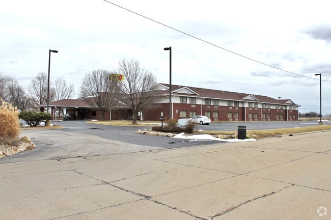


This Property Is For Sale
Property Detail
1100 Eastgate Dr
St. Louis, MO-IL
EASTGATE LOT/SEC-4 A02384130
04-33.0-201-005
Saint Clair
Hotelormotel
Illinois
2024
2.92 AC
2024
St Louis East
504352
St. Louis
26,653 SF
NEARBY LISTINGS FOR SALE OR LEASE
-
-
View all O Fallon listings for sale on LoopNet.com
DEMOGRAPHICS near 1100 Eastgate Dr
1 mile
3 mile
5 mile
2025 Total Population
920
23,513
59,188
2030 Population
898
22,965
58,028
Pop Growth 2025-2030
(2.39%)
(2.33%)
(1.96%)
Average Age
43
39
39
2025 Total Households
409
9,417
22,789
HH Growth 2025-2030
(2.44%)
(2.52%)
(2.05%)
Median Household Inc
$73,306
$89,550
$100,642
Avg Household Size
2.20
2.50
2.50
2025 Avg HH Vehicles
2.00
2.00
2.00
Median Home Value
$236,486
$255,035
$271,174
Median Year Built
1986
1987
1994
Nearby Places
Map Layers
Map Styles
 Street
 Aerial
Layers
 Traffic
 Biking
Places
Listings with unknown addresses are not visible on the map
- Restaurants
- Banks
- Shops
- Fitness
- Groceries
PUBLIC TRANSPORTATION
COMMUTER RAIL
Shiloh-Scott (Lambert Airport Shiloh-Scott - St. Louis MetroLink (MetroLink))
Drive
Walk
Distance
Shiloh-Scott (Lambert Airport Shiloh-Scott - St. Louis MetroLink (MetroLink))
8 min
3.9 mi
College (Lambert Airport Shiloh-Scott - St. Louis MetroLink (MetroLink))
Drive
Walk
Distance
College (Lambert Airport Shiloh-Scott - St. Louis MetroLink (MetroLink))
13 min
7.3 mi
AIRPORT
Scott AFB/Midamerica St Louis
Drive
Walk
Distance
Scott AFB/Midamerica St Louis
17 min
7.5 mi
St Louis Lambert International
Drive
Walk
Distance
St Louis Lambert International
46 min
33.1 mi
Freight Ports
Port Milwaukee
Drive
Walk
Distance
Port Milwaukee
417 min
363.9 mi
Nearby Properties
Address
Land Use
TOTAL SIZE
Lot Size
Zoning
Address
Land Use
TOTAL SIZE
Lot Size
Zoning
70,515 SF
27.95 AC
Address
Land Use
TOTAL SIZE
Lot Size
Zoning
17,676 SF
3.09 AC
Address
Land Use
TOTAL SIZE
Lot Size
Zoning
Address
Land Use
TOTAL SIZE
Lot Size
Zoning
10.08 AC
Address
Land Use
TOTAL SIZE
Lot Size
Zoning
Address
Land Use
TOTAL SIZE
Lot Size
Zoning
3.24 AC
Address
Land Use
TOTAL SIZE
Lot Size
Zoning
8,141 SF
16.74 AC
Address
Land Use
TOTAL SIZE
Lot Size
Zoning
9.63 AC
Address
Land Use
TOTAL SIZE
Lot Size
Zoning
1.94 AC
Address
Land Use
TOTAL SIZE
Lot Size
Zoning
81.90 AC
Address
Land Use
TOTAL SIZE
Lot Size
Zoning
Address
Land Use
TOTAL SIZE
Lot Size
Zoning
37,197 SF
6.20 AC
Address
Land Use
TOTAL SIZE
Lot Size
Zoning
37,201 SF
4.52 AC
Address
Land Use
TOTAL SIZE
Lot Size
Zoning
125,576 SF
3.48 AC
Address
Land Use
TOTAL SIZE
Lot Size
Zoning
11,100 SF
1.53 AC
Address
Land Use
TOTAL SIZE
Lot Size
Zoning
17,290 SF
2.51 AC
Address
Land Use
TOTAL SIZE
Lot Size
Zoning
Address
Land Use
TOTAL SIZE
Lot Size
Zoning
28,329 SF
3.08 AC
Address
Land Use
TOTAL SIZE
Lot Size
Zoning
Address
Land Use
TOTAL SIZE
Lot Size
Zoning
Address
Land Use
TOTAL SIZE
Lot Size
Zoning
3,840 SF
6.48 AC
Address
Land Use
TOTAL SIZE
Lot Size
Zoning
4.26 AC
Address
Land Use
TOTAL SIZE
Lot Size
Zoning
32,385 SF
2.78 AC
Address
Land Use
TOTAL SIZE
Lot Size
Zoning
56,415 SF
5.77 AC
Address
Land Use
TOTAL SIZE
Lot Size
Zoning
30,000 SF
3.54 AC
Address
Land Use
TOTAL SIZE
Lot Size
Zoning
Address
Land Use
TOTAL SIZE
Lot Size
Zoning
Address
Land Use
TOTAL SIZE
Lot Size
Zoning
3,168 SF
2.10 AC
Address
Land Use
TOTAL SIZE
Lot Size
Zoning
20.34 AC
Address
Land Use
TOTAL SIZE
Lot Size
Zoning
The World's #1 Commercial Real Estate Marketplace
Connect with us
© 2026 CoStar Group
The information above has been obtained from sources believed reliable. While we do not doubt its accuracy we have not verified it and make no guarantee, warranty or representation about it. It is your responsibility to independently confirm its accuracy and completeness. Any projections, opinions, assumptions, or estimates used are for example only and do not represent the current or future performance of the property. The value of this transaction to you depends on tax and other factors which should be evaluated by your tax, financial, and legal advisors. You and your advisors should conduct a careful, independent investigation of the property to determine to your satisfaction the suitability of the property for your needs.