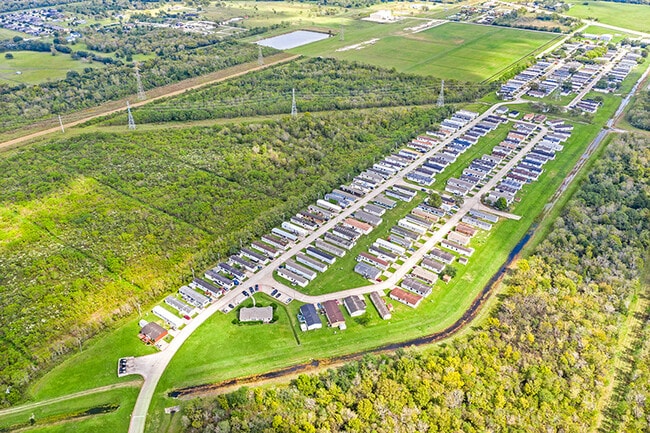
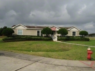
Property Record
1100 Fm Dr, Alvin, TX 77511

NEARBY LISTINGS FOR SALE OR LEASE
-
-
View all Alvin listings for sale on LoopNet.com
Property Detail
1100 Fm Dr
Houston-The Woodlands-Sugar Land, TX
Hooper & Wade
0491-0027-100
A0491 HOOPER & WADE BLOCK 4 TRACT 2B-3A BLK 5 LOT 2A ACRES 25.064 (ALVIN)
Commercialnec
Brazoria
AO
Texas
48039C0155K
2a
2024
20.24 AC
2025
South Brazoria County
661100
Houston
145 SF
DEMOGRAPHICS near 1100 Fm Dr
1 Mile
3 Mile
5 Mile
2024 Total Population
2,273
23,299
71,552
2029 Population
2,519
25,662
77,674
Pop Growth 2024-2029
+ 10.82%
+ 10.14%
+ 8.56%
Average Age
36
37
38
2024 Total Households
797
8,009
24,487
HH Growth 2024-2029
+ 11.04%
+ 10.40%
+ 8.85%
Median Household Inc
$72,691
$81,193
$83,932
Avg Household Size
2.80
2.80
2.80
2024 Avg HH Vehicles
2.00
2.00
2.00
Median Home Value
$235,049
$241,332
$275,796
Median Year Built
2000
1991
1992
Nearby Places
Map Layers
Map Styles
 Street
 Aerial
- Restaurants
- Banks
- Shops
- Fitness
- Groceries
PUBLIC TRANSPORTATION
AIRPORT
William P Hobby
DRIVE
WALK
Distance
William P Hobby
28 min
14.5 mi
Freight Ports
Port of Houston
DRIVE
WALK
Distance
Port of Houston
39 min
22.7 mi
SALE & LEASE HISTORY
LISTING DATE
SALE/LEASE

Nov 16, 2020
For Sale
Nearby Properties
Address
Land Use
TOTAL SIZE
Lot Size
Zoning
Address
Land Use
TOTAL SIZE
Lot Size
Zoning
65,935 SF
81.27 AC
Address
Land Use
TOTAL SIZE
Lot Size
Zoning
39.21 AC
0113
Address
Land Use
TOTAL SIZE
Lot Size
Zoning
84,272 SF
16.93 AC
Address
Land Use
TOTAL SIZE
Lot Size
Zoning
13.56 AC
Address
Land Use
TOTAL SIZE
Lot Size
Zoning
197,506 SF
20.52 AC
Address
Land Use
TOTAL SIZE
Lot Size
Zoning
209,431 SF
17.44 AC
Address
Land Use
TOTAL SIZE
Lot Size
Zoning
74,780 SF
5.51 AC
0034
Address
Land Use
TOTAL SIZE
Lot Size
Zoning
68,435 SF
5.62 AC
0041
Address
Land Use
TOTAL SIZE
Lot Size
Zoning
110,165 SF
12.32 AC
Address
Land Use
TOTAL SIZE
Lot Size
Zoning
83,344 SF
4.40 AC
0002
Address
Land Use
TOTAL SIZE
Lot Size
Zoning
111,370 SF
11.10 AC
Address
Land Use
TOTAL SIZE
Lot Size
Zoning
90,044 SF
9.62 AC
Address
Land Use
TOTAL SIZE
Lot Size
Zoning
276,750 SF
35.24 AC
Address
Land Use
TOTAL SIZE
Lot Size
Zoning
136,700 SF
9.91 AC
0095
Address
Land Use
TOTAL SIZE
Lot Size
Zoning
147,939 SF
38.36 AC
0026
Address
Land Use
TOTAL SIZE
Lot Size
Zoning
89,466 SF
8.61 AC
0109
Address
Land Use
TOTAL SIZE
Lot Size
Zoning
36,596 SF
14.75 AC
Address
Land Use
TOTAL SIZE
Lot Size
Zoning
22,144 SF
9.27 AC
Address
Land Use
TOTAL SIZE
Lot Size
Zoning
74,406 SF
11.99 AC
Address
Land Use
TOTAL SIZE
Lot Size
Zoning
10,160 SF
1.57 AC
Address
Land Use
TOTAL SIZE
Lot Size
Zoning
44,501 SF
4.15 AC
Address
Land Use
TOTAL SIZE
Lot Size
Zoning
22,400 SF
2.25 AC
0067
Address
Land Use
TOTAL SIZE
Lot Size
Zoning
57.64 AC
0184
Address
Land Use
TOTAL SIZE
Lot Size
Zoning
74,002 SF
9.58 AC
Address
Land Use
TOTAL SIZE
Lot Size
Zoning
16,620 SF
1.59 AC
Address
Land Use
TOTAL SIZE
Lot Size
Zoning
63,530 SF
8.89 AC
0022
Address
Land Use
TOTAL SIZE
Lot Size
Zoning
40,484 SF
1.96 AC
Address
Land Use
TOTAL SIZE
Lot Size
Zoning
25,352 SF
2.29 AC
Address
Land Use
TOTAL SIZE
Lot Size
Zoning
94,809 SF
49.01 AC
0103
The World's #1 Commercial Real Estate Marketplace
Connect with us
© 2025 CoStar Group
The information above has been obtained from sources believed reliable. While we do not doubt its accuracy we have not verified it and make no guarantee, warranty or representation about it. It is your responsibility to independently confirm its accuracy and completeness. Any projections, opinions, assumptions, or estimates used are for example only and do not represent the current or future performance of the property. The value of this transaction to you depends on tax and other factors which should be evaluated by your tax, financial, and legal advisors. You and your advisors should conduct a careful, independent investigation of the property to determine to your satisfaction the suitability of the property for your needs.