Property Record
1100 E Hammond Rd E, Traverse City, MI 49686


Save to a Folder
{{folder.Name}}
{{folder.ListingIds.length}} Properties
{{folder.ListingIds.length}} Property
Create a New Folder
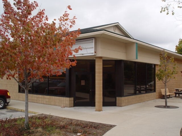
Property Detail
1100 E Hammond Rd E
03-229-011-30
PART OF NW 1/4 OF SEC 29 T27N R10W DESC AS: BEG AT NW COR OF SEC 29 TH S 89 DEG 00 MIN 33 SEC E 707.22 FT ALG N LN OF SAID SE
Commercialnec
Grand Traverse
B and X Area of moderate flood hazard, usually the area between the limits of the 100-year and 500-year floods.
Michigan
2025
9.25 AC
2026
Michigan Northwest Area
550602
Other Market Areas
47,010 SF
Traverse City, MI
NEARBY LISTINGS FOR SALE OR LEASE
DEMOGRAPHICS near 1100 E Hammond Rd E
1 mile
3 mile
5 mile
2025 Total Population
1,296
13,904
38,272
2030 Population
1,287
13,720
38,055
Pop Growth 2025-2030
(0.69%)
(1.32%)
(0.57%)
Average Age
42
42
43
2025 Total Households
487
6,016
17,172
HH Growth 2025-2030
(0.62%)
(1.35%)
(0.53%)
Median Household Inc
$100,702
$73,150
$75,629
Avg Household Size
2.60
2.20
2.10
2025 Avg HH Vehicles
2.00
2.00
2.00
Median Home Value
$322,222
$260,658
$330,256
Median Year Built
1992
1988
1983
Nearby Places
Map Layers
Map Styles
 Street
 Aerial
Layers
 Traffic
 Biking
Places
Listings with unknown addresses are not visible on the map
- Restaurants
- Banks
- Shops
- Fitness
- Groceries
PUBLIC TRANSPORTATION
AIRPORT
Cherry Capital
Drive
Walk
Distance
Cherry Capital
13 min
4.9 mi
Freight Ports
Port Milwaukee
Drive
Walk
Distance
Port Milwaukee
456 min
398.2 mi
SALE & LEASE HISTORY
LISTING DATE
SALE/LEASE

Nov 19, 2019
For Lease
Nearby Properties
Address
Land Use
TOTAL SIZE
Lot Size
Zoning
Address
Land Use
TOTAL SIZE
Lot Size
Zoning
5,308 SF
27.64 AC
Address
Land Use
TOTAL SIZE
Lot Size
Zoning
41,084 SF
22.79 AC
Address
Land Use
TOTAL SIZE
Lot Size
Zoning
189,750 SF
94.80 AC
Address
Land Use
TOTAL SIZE
Lot Size
Zoning
25,208 SF
15.01 AC
Address
Land Use
TOTAL SIZE
Lot Size
Zoning
88,964 SF
0.86 AC
Address
Land Use
TOTAL SIZE
Lot Size
Zoning
81,900 SF
870.88 AC
Address
Land Use
TOTAL SIZE
Lot Size
Zoning
6,354 SF
97.88 AC
Address
Land Use
TOTAL SIZE
Lot Size
Zoning
8,820 SF
15.24 AC
Address
Land Use
TOTAL SIZE
Lot Size
Zoning
40,790 SF
2.31 AC
Address
Land Use
TOTAL SIZE
Lot Size
Zoning
720 SF
3.80 AC
Address
Land Use
TOTAL SIZE
Lot Size
Zoning
45,574 SF
21.75 AC
Address
Land Use
TOTAL SIZE
Lot Size
Zoning
78,933 SF
19.79 AC
Address
Land Use
TOTAL SIZE
Lot Size
Zoning
40,900 SF
3.03 AC
Address
Land Use
TOTAL SIZE
Lot Size
Zoning
100,409 SF
32.45 AC
Address
Land Use
TOTAL SIZE
Lot Size
Zoning
67,257 SF
3.50 AC
Address
Land Use
TOTAL SIZE
Lot Size
Zoning
65,000 SF
7.04 AC
Address
Land Use
TOTAL SIZE
Lot Size
Zoning
155,882 SF
19.57 AC
Address
Land Use
TOTAL SIZE
Lot Size
Zoning
91,128 SF
7.09 AC
Address
Land Use
TOTAL SIZE
Lot Size
Zoning
41,472 SF
1.72 AC
Address
Land Use
TOTAL SIZE
Lot Size
Zoning
Address
Land Use
TOTAL SIZE
Lot Size
Zoning
50,096 SF
2.31 AC
Address
Land Use
TOTAL SIZE
Lot Size
Zoning
27,889 SF
14.55 AC
Address
Land Use
TOTAL SIZE
Lot Size
Zoning
Address
Land Use
TOTAL SIZE
Lot Size
Zoning
9,608 SF
10.99 AC
Address
Land Use
TOTAL SIZE
Lot Size
Zoning
48,816 SF
2.47 AC
Address
Land Use
TOTAL SIZE
Lot Size
Zoning
215,470 SF
21.20 AC
Address
Land Use
TOTAL SIZE
Lot Size
Zoning
43,100 SF
10.29 AC
Address
Land Use
TOTAL SIZE
Lot Size
Zoning
Address
Land Use
TOTAL SIZE
Lot Size
Zoning
50,486 SF
35.66 AC
Address
Land Use
TOTAL SIZE
Lot Size
Zoning
63,716 SF
33.08 AC
The World's #1 Commercial Real Estate Marketplace
Connect with us
© 2026 CoStar Group
The information above has been obtained from sources believed reliable. While we do not doubt its accuracy we have not verified it and make no guarantee, warranty or representation about it. It is your responsibility to independently confirm its accuracy and completeness. Any projections, opinions, assumptions, or estimates used are for example only and do not represent the current or future performance of the property. The value of this transaction to you depends on tax and other factors which should be evaluated by your tax, financial, and legal advisors. You and your advisors should conduct a careful, independent investigation of the property to determine to your satisfaction the suitability of the property for your needs.