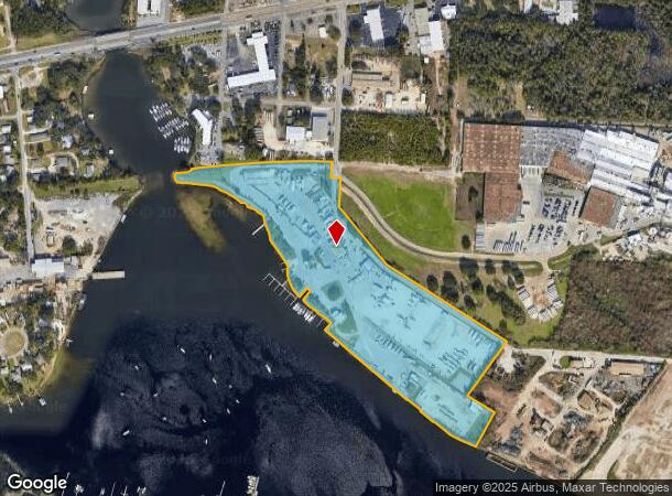
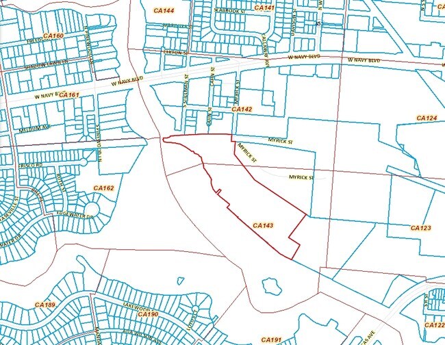
Property Record
300 S Stillman St Blk St, Pensacola, FL 32505

NEARBY LISTINGS FOR SALE OR LEASE
Property Detail
300 S Stillman St Blk St
Pensacola-Ferry Pass-Brent, FL
Pettersen Addition
00-0S-00-9090-003-043
BEG SE COR OF BLK 87 PETTERSEN ADDN THOMAS C. WATSON MAP 1906 BEING INTER OF N R/W LI OF FLETTNER ST (3RD ST 75 FT R/W) AND INTER OF W R/W LI OF MULDON ST. (P ST. 60 FT R/W) S 89 DEG 14 MIN 08 SEC W ALG N R/W LI 843.74 FT TO W LI OF ARMSTRONG WORLD I
Airport
Escambia
AE
Florida
12033C0370G
3
2023
26.30 AC
2024
Central Pensacola/S Brent
003100
Pensacola
13,042 SF
DEMOGRAPHICS near 300 S Stillman St Blk St
1 Mile
3 Mile
5 Mile
2024 Total Population
6,464
56,587
128,953
2029 Population
6,678
58,571
132,197
Pop Growth 2024-2029
+ 3.31%
+ 3.51%
+ 2.52%
Average Age
38
39
38
2024 Total Households
2,780
23,024
49,049
HH Growth 2024-2029
+ 3.31%
+ 3.56%
+ 2.57%
Median Household Inc
$33,191
$34,988
$43,772
Avg Household Size
2.30
2.20
2.30
2024 Avg HH Vehicles
1.00
1.00
2.00
Median Home Value
$97,272
$130,923
$160,827
Median Year Built
1958
1965
1971
Nearby Places
Map Layers
Map Styles
 Street
 Aerial
- Restaurants
- Banks
- Shops
- Fitness
- Groceries
PUBLIC TRANSPORTATION
AIRPORT
Pensacola International
DRIVE
WALK
Distance
Pensacola International
16 min
7.4 mi
Freight Ports
Port of Mobile
DRIVE
WALK
Distance
Port of Mobile
71 min
58.0 mi
Nearby Properties
Address
Land Use
TOTAL SIZE
Lot Size
Zoning
Address
Land Use
TOTAL SIZE
Lot Size
Zoning
6,950 SF
584.36 AC
PUB
Address
Land Use
TOTAL SIZE
Lot Size
Zoning
544,835 SF
3.29 AC
C-2,C-2A
Address
Land Use
TOTAL SIZE
Lot Size
Zoning
365,037 SF
5.79 AC
C-3
Address
Land Use
TOTAL SIZE
Lot Size
Zoning
368,724 SF
3.17 AC
C-2A
Address
Land Use
TOTAL SIZE
Lot Size
Zoning
56,970 SF
5.94 AC
WRD
Address
Land Use
TOTAL SIZE
Lot Size
Zoning
289,397 SF
12.38 AC
PUB
Address
Land Use
TOTAL SIZE
Lot Size
Zoning
219,481 SF
161.44 AC
NONE
Address
Land Use
TOTAL SIZE
Lot Size
Zoning
334,324 SF
55.06 AC
PUB
Address
Land Use
TOTAL SIZE
Lot Size
Zoning
353,428 SF
30.10 AC
M-1
Address
Land Use
TOTAL SIZE
Lot Size
Zoning
327,045 SF
7.47 AC
C-2A
Address
Land Use
TOTAL SIZE
Lot Size
Zoning
178,451 SF
3.88 AC
GRD
Address
Land Use
TOTAL SIZE
Lot Size
Zoning
188,512 SF
11.44 AC
COM
Address
Land Use
TOTAL SIZE
Lot Size
Zoning
114,000 SF
3.23 AC
C-2,C-2A
Address
Land Use
TOTAL SIZE
Lot Size
Zoning
96,686 SF
1.06 AC
C-2A
Address
Land Use
TOTAL SIZE
Lot Size
Zoning
127,684 SF
8.24 AC
HDR
Address
Land Use
TOTAL SIZE
Lot Size
Zoning
282,738 SF
14.64 AC
PUB
Address
Land Use
TOTAL SIZE
Lot Size
Zoning
258,438 SF
48.49 AC
PUB
Address
Land Use
TOTAL SIZE
Lot Size
Zoning
99,623 SF
1.87 AC
C-2A
Address
Land Use
TOTAL SIZE
Lot Size
Zoning
145,264 SF
9.84 AC
SSD
Address
Land Use
TOTAL SIZE
Lot Size
Zoning
169,346 SF
15.21 AC
HDR
Address
Land Use
TOTAL SIZE
Lot Size
Zoning
115,500 SF
3.48 AC
C-2
Address
Land Use
TOTAL SIZE
Lot Size
Zoning
151,996 SF
30.44 AC
HDR
Address
Land Use
TOTAL SIZE
Lot Size
Zoning
166,204 SF
0.97 AC
C-2A
Address
Land Use
TOTAL SIZE
Lot Size
Zoning
75,877 SF
1.55 AC
WRD
Address
Land Use
TOTAL SIZE
Lot Size
Zoning
130,516 SF
4.55 AC
R-2
Address
Land Use
TOTAL SIZE
Lot Size
Zoning
55,337 SF
0.95 AC
C-2A,HC-2
Address
Land Use
TOTAL SIZE
Lot Size
Zoning
99,147 SF
5.89 AC
HDMU
Address
Land Use
TOTAL SIZE
Lot Size
Zoning
116,020 SF
4.71 AC
MDR
Address
Land Use
TOTAL SIZE
Lot Size
Zoning
81,549 SF
0.46 AC
WRD
Address
Land Use
TOTAL SIZE
Lot Size
Zoning
197,958 SF
26.08 AC
COM
The World's #1 Commercial Real Estate Marketplace
Connect with us
© 2025 CoStar Group
The information above has been obtained from sources believed reliable. While we do not doubt its accuracy we have not verified it and make no guarantee, warranty or representation about it. It is your responsibility to independently confirm its accuracy and completeness. Any projections, opinions, assumptions, or estimates used are for example only and do not represent the current or future performance of the property. The value of this transaction to you depends on tax and other factors which should be evaluated by your tax, financial, and legal advisors. You and your advisors should conduct a careful, independent investigation of the property to determine to your satisfaction the suitability of the property for your needs.