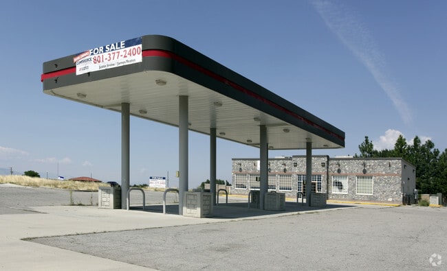
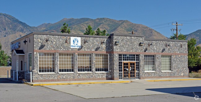
Property Record
1100 N 1600 E, Mapleton, UT 84664

Property Detail
1100 N 1600 E
Provo-Orem-Lehi, UT
COM S 0 DEG 25 32 E 1840.69 FT & W 29.86 FT FR NE COR. SEC. 9, T8S, R3E, SLB&M.; S 0 DEG 25 32 E 329.63 FT; S 89 DEG 34 28 W 48.71 FT; ALONG A CURVE TO L (CHORD BEARS: N 22 DEG 30 21 W 357.16 FT, RADIUS = 2342 FT); N 89 DEG 59 30 E 182.97 FT TO BEG.
26-058-0100
UTAH
Storebuilding
Utah
2024
0.84 AC
2025
Utah County
010303
Salt Lake City
3,025 SF
NEARBY LISTINGS FOR SALE OR LEASE
DEMOGRAPHICS near 1100 N 1600 E
1 mile
3 mile
5 mile
2025 Total Population
8,970
63,938
102,479
2030 Population
9,967
70,468
112,822
Pop Growth 2025-2030
+ 11.11%
+ 10.21%
+ 10.09%
Average Age
34
33
33
2025 Total Households
2,403
17,817
28,608
HH Growth 2025-2030
+ 11.74%
+ 10.81%
+ 10.77%
Median Household Inc
$109,292
$104,991
$103,424
Avg Household Size
3.80
3.60
3.60
2025 Avg HH Vehicles
3.00
2.00
3.00
Median Home Value
$677,656
$577,174
$546,417
Median Year Built
2000
2001
2000
Nearby Places
Map Layers
Map Styles
 Street
 Aerial
Transit
 Traffic
 Biking
Places
Listings with unknown addresses are not visible on the map
- Restaurants
- Banks
- Shops
- Fitness
- Groceries
PUBLIC TRANSPORTATION
COMMUTER RAIL
Provo Central Station (FrontRunner - Utah Transit Authority (UTA))
Drive
Walk
Distance
Provo Central Station (FrontRunner - Utah Transit Authority (UTA))
13 min
8.4 mi
Provo Amtrak (California Zephyr - Amtrak)
Drive
Walk
Distance
Provo Amtrak (California Zephyr - Amtrak)
13 min
8.4 mi
AIRPORT
Provo Municipal
Drive
Walk
Distance
Provo Municipal
17 min
10.4 mi
Freight Ports
Port of Stockton
Drive
Walk
Distance
Port of Stockton
766 min
747.0 mi
Nearby Properties
Address
Land Use
TOTAL SIZE
Lot Size
Zoning
Address
Land Use
TOTAL SIZE
Lot Size
Zoning
44,552 SF
29.78 AC
Address
Land Use
TOTAL SIZE
Lot Size
Zoning
565,605 SF
20 AC
Address
Land Use
TOTAL SIZE
Lot Size
Zoning
281,008 SF
16.65 AC
Address
Land Use
TOTAL SIZE
Lot Size
Zoning
281,008 SF
14.84 AC
Address
Land Use
TOTAL SIZE
Lot Size
Zoning
170,774 SF
9.70 AC
Address
Land Use
TOTAL SIZE
Lot Size
Zoning
243,888 SF
32.23 AC
Address
Land Use
TOTAL SIZE
Lot Size
Zoning
159,679 SF
12.91 AC
Address
Land Use
TOTAL SIZE
Lot Size
Zoning
322,432 SF
29.36 AC
Address
Land Use
TOTAL SIZE
Lot Size
Zoning
210,644 SF
19.55 AC
Address
Land Use
TOTAL SIZE
Lot Size
Zoning
125,729 SF
12.84 AC
Address
Land Use
TOTAL SIZE
Lot Size
Zoning
184,079 SF
11.47 AC
Address
Land Use
TOTAL SIZE
Lot Size
Zoning
149,046 SF
12.10 AC
Address
Land Use
TOTAL SIZE
Lot Size
Zoning
79,260 SF
5.24 AC
Address
Land Use
TOTAL SIZE
Lot Size
Zoning
124,255 SF
9.87 AC
Address
Land Use
TOTAL SIZE
Lot Size
Zoning
112,094 SF
10.34 AC
Address
Land Use
TOTAL SIZE
Lot Size
Zoning
72,453 SF
14.17 AC
Address
Land Use
TOTAL SIZE
Lot Size
Zoning
181,993 SF
5.01 AC
Address
Land Use
TOTAL SIZE
Lot Size
Zoning
96,879 SF
7.91 AC
Address
Land Use
TOTAL SIZE
Lot Size
Zoning
82,610 SF
2.46 AC
Address
Land Use
TOTAL SIZE
Lot Size
Zoning
82,610 SF
2.02 AC
Address
Land Use
TOTAL SIZE
Lot Size
Zoning
110,762 SF
6.08 AC
Address
Land Use
TOTAL SIZE
Lot Size
Zoning
62,203 SF
2.13 AC
Address
Land Use
TOTAL SIZE
Lot Size
Zoning
90,249 SF
4.33 AC
Address
Land Use
TOTAL SIZE
Lot Size
Zoning
37,031 SF
4.73 AC
Address
Land Use
TOTAL SIZE
Lot Size
Zoning
51,530 SF
4.58 AC
Address
Land Use
TOTAL SIZE
Lot Size
Zoning
92,026 SF
9.99 AC
Address
Land Use
TOTAL SIZE
Lot Size
Zoning
51,611 SF
9.81 AC
Address
Land Use
TOTAL SIZE
Lot Size
Zoning
89,591 SF
9.01 AC
Address
Land Use
TOTAL SIZE
Lot Size
Zoning
89,597 SF
5.92 AC
Address
Land Use
TOTAL SIZE
Lot Size
Zoning
14,844 SF
1.76 AC
The World's #1 Commercial Real Estate Marketplace
Connect with us
© 2026 CoStar Group
The information above has been obtained from sources believed reliable. While we do not doubt its accuracy we have not verified it and make no guarantee, warranty or representation about it. It is your responsibility to independently confirm its accuracy and completeness. Any projections, opinions, assumptions, or estimates used are for example only and do not represent the current or future performance of the property. The value of this transaction to you depends on tax and other factors which should be evaluated by your tax, financial, and legal advisors. You and your advisors should conduct a careful, independent investigation of the property to determine to your satisfaction the suitability of the property for your needs.