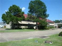
Property Record
1100 N 18Th St, Monroe, LA 71201

NEARBY LISTINGS FOR SALE OR LEASE
Property Detail
1100 N 18Th St
39535
Roselawn Addn Unit-02
Officebuilding
LOT IN SQ 6 ROSELAWN ADDN BEG AT SW COR SQ 6, BEING INTERSECTION OF NE LINE NORTH 18TH ST WITH NW LINE STUBBS AVE, NE 210 FT,
X
Ouachita
22073C0165F
Louisiana
2025
1.29 AC
2025
Louisiana North Area
001700
Other Market Areas
15,144 SF
Monroe, LA
DEMOGRAPHICS near 1100 N 18Th St
1 mile
3 mile
5 mile
2024 Total Population
6,259
49,109
89,995
2029 Population
6,144
48,337
88,485
Pop Growth 2024-2029
(1.84%)
(1.57%)
(1.68%)
Average Age
40
38
39
2024 Total Households
2,978
20,047
36,585
HH Growth 2024-2029
(1.85%)
(1.62%)
(1.75%)
Median Household Inc
$38,871
$37,847
$37,229
Avg Household Size
2.00
2.30
2.30
2024 Avg HH Vehicles
1.00
1.00
1.00
Median Home Value
$169,879
$159,912
$154,136
Median Year Built
1968
1972
1976
Nearby Places
Map Layers
Map Styles
 Street
 Aerial
Transit
 Traffic
 Biking
Places
Listings with unknown addresses are not visible on the map
- Restaurants
- Banks
- Shops
- Fitness
- Groceries
PUBLIC TRANSPORTATION
AIRPORT
Monroe Regional
Drive
Walk
Distance
Monroe Regional
10 min
5.5 mi
Nearby Properties
Address
Land Use
TOTAL SIZE
Lot Size
Zoning
Address
Land Use
TOTAL SIZE
Lot Size
Zoning
2.23 AC
Address
Land Use
TOTAL SIZE
Lot Size
Zoning
Address
Land Use
TOTAL SIZE
Lot Size
Zoning
7.63 AC
Address
Land Use
TOTAL SIZE
Lot Size
Zoning
Address
Land Use
TOTAL SIZE
Lot Size
Zoning
Address
Land Use
TOTAL SIZE
Lot Size
Zoning
10.81 AC
Address
Land Use
TOTAL SIZE
Lot Size
Zoning
2.49 AC
Address
Land Use
TOTAL SIZE
Lot Size
Zoning
22.96 AC
Address
Land Use
TOTAL SIZE
Lot Size
Zoning
1.37 AC
Address
Land Use
TOTAL SIZE
Lot Size
Zoning
0.14 AC
Address
Land Use
TOTAL SIZE
Lot Size
Zoning
15.74 AC
Address
Land Use
TOTAL SIZE
Lot Size
Zoning
10.80 AC
Address
Land Use
TOTAL SIZE
Lot Size
Zoning
23.29 AC
Address
Land Use
TOTAL SIZE
Lot Size
Zoning
14.07 AC
Address
Land Use
TOTAL SIZE
Lot Size
Zoning
5.21 AC
Address
Land Use
TOTAL SIZE
Lot Size
Zoning
Address
Land Use
TOTAL SIZE
Lot Size
Zoning
18.85 AC
Address
Land Use
TOTAL SIZE
Lot Size
Zoning
Address
Land Use
TOTAL SIZE
Lot Size
Zoning
Address
Land Use
TOTAL SIZE
Lot Size
Zoning
6.42 AC
Address
Land Use
TOTAL SIZE
Lot Size
Zoning
Address
Land Use
TOTAL SIZE
Lot Size
Zoning
1.16 AC
Address
Land Use
TOTAL SIZE
Lot Size
Zoning
1.67 AC
Address
Land Use
TOTAL SIZE
Lot Size
Zoning
Address
Land Use
TOTAL SIZE
Lot Size
Zoning
37.47 AC
Address
Land Use
TOTAL SIZE
Lot Size
Zoning
4.54 AC
Address
Land Use
TOTAL SIZE
Lot Size
Zoning
0.52 AC
Address
Land Use
TOTAL SIZE
Lot Size
Zoning
Address
Land Use
TOTAL SIZE
Lot Size
Zoning
Address
Land Use
TOTAL SIZE
Lot Size
Zoning
The World's #1 Commercial Real Estate Marketplace
Connect with us
© 2026 CoStar Group
The information above has been obtained from sources believed reliable. While we do not doubt its accuracy we have not verified it and make no guarantee, warranty or representation about it. It is your responsibility to independently confirm its accuracy and completeness. Any projections, opinions, assumptions, or estimates used are for example only and do not represent the current or future performance of the property. The value of this transaction to you depends on tax and other factors which should be evaluated by your tax, financial, and legal advisors. You and your advisors should conduct a careful, independent investigation of the property to determine to your satisfaction the suitability of the property for your needs.