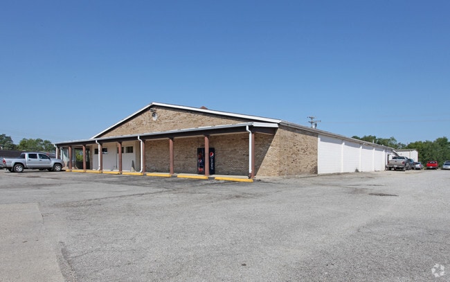
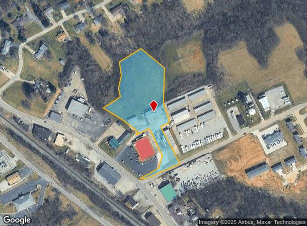
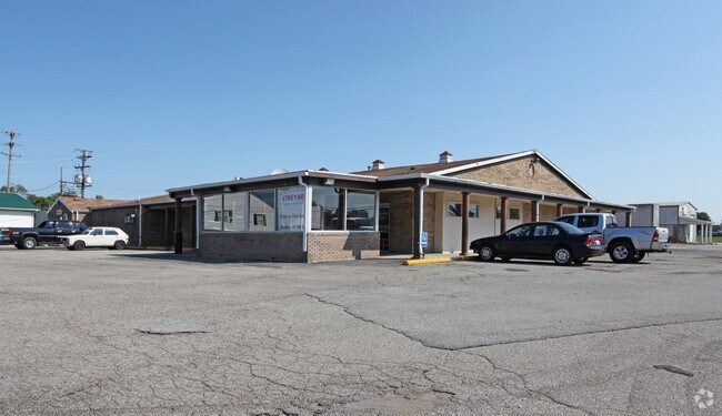
Property Record
1100 N Main St, Williamstown, KY 41097
NEARBY LISTINGS FOR SALE OR LEASE
-
-
View all Williamstown listings for sale on LoopNet.com
Property Detail
1100 N Main St
058-00-00-012.01
BLDGS & 3.25 ACRES
Wholesaleoutletdiscountstore
Grant
X
Kentucky
21191C0125E
3.25 AC
2025
Grant County
2025
Cincinnati/Dayton
920302
Cincinnati, OH-KY-IN
9,600 SF
DEMOGRAPHICS near 1100 N Main St
1 Mile
3 Mile
5 Mile
2024 Total Population
1,720
6,471
11,007
2029 Population
1,821
6,894
11,707
Pop Growth 2024-2029
+ 5.87%
+ 6.54%
+ 6.36%
Average Age
38
38
39
2024 Total Households
627
2,334
3,985
HH Growth 2024-2029
+ 5.74%
+ 6.56%
+ 6.40%
Median Household Inc
$49,999
$49,887
$57,773
Avg Household Size
2.50
2.60
2.70
2024 Avg HH Vehicles
2.00
2.00
2.00
Median Home Value
$168,789
$167,812
$173,157
Median Year Built
1975
1979
1984
Nearby Places
Map Layers
Map Styles
 Street
 Aerial
- Restaurants
- Banks
- Shops
- Fitness
- Groceries
PUBLIC TRANSPORTATION
AIRPORT
Cincinnati/Northern Kentucky International
DRIVE
WALK
Distance
Cincinnati/Northern Kentucky International
44 min
31.5 mi
Freight Ports
Port of Toledo
DRIVE
WALK
Distance
Port of Toledo
285 min
243.5 mi
SALE & LEASE HISTORY
LISTING DATE
SALE/LEASE

Jan 10, 2017
For Sale
Nearby Properties
Address
Land Use
TOTAL SIZE
Lot Size
Zoning
Address
Land Use
TOTAL SIZE
Lot Size
Zoning
321,300 SF
28.87 AC
Address
Land Use
TOTAL SIZE
Lot Size
Zoning
154,743 SF
16.19 AC
COM
Address
Land Use
TOTAL SIZE
Lot Size
Zoning
3.03 AC
Address
Land Use
TOTAL SIZE
Lot Size
Zoning
Address
Land Use
TOTAL SIZE
Lot Size
Zoning
29,364 SF
9.94 AC
Address
Land Use
TOTAL SIZE
Lot Size
Zoning
Address
Land Use
TOTAL SIZE
Lot Size
Zoning
7.62 AC
Address
Land Use
TOTAL SIZE
Lot Size
Zoning
31.95 AC
Address
Land Use
TOTAL SIZE
Lot Size
Zoning
10.81 AC
Address
Land Use
TOTAL SIZE
Lot Size
Zoning
21,420 SF
4.83 AC
Address
Land Use
TOTAL SIZE
Lot Size
Zoning
3,350 SF
1 AC
COM
Address
Land Use
TOTAL SIZE
Lot Size
Zoning
100.80 AC
Address
Land Use
TOTAL SIZE
Lot Size
Zoning
6,272 SF
5.75 AC
Address
Land Use
TOTAL SIZE
Lot Size
Zoning
Address
Land Use
TOTAL SIZE
Lot Size
Zoning
4,230 SF
0.84 AC
COM
Address
Land Use
TOTAL SIZE
Lot Size
Zoning
35,685 SF
1.32 AC
COM
Address
Land Use
TOTAL SIZE
Lot Size
Zoning
14,142 SF
3 AC
Address
Land Use
TOTAL SIZE
Lot Size
Zoning
5,100 SF
0.85 AC
Address
Land Use
TOTAL SIZE
Lot Size
Zoning
16,545 SF
3.34 AC
Address
Land Use
TOTAL SIZE
Lot Size
Zoning
276.50 AC
Address
Land Use
TOTAL SIZE
Lot Size
Zoning
22,152 SF
1.13 AC
COM
Address
Land Use
TOTAL SIZE
Lot Size
Zoning
17,022 SF
4.54 AC
Address
Land Use
TOTAL SIZE
Lot Size
Zoning
13,296 SF
4.31 AC
Address
Land Use
TOTAL SIZE
Lot Size
Zoning
Address
Land Use
TOTAL SIZE
Lot Size
Zoning
11.20 AC
Address
Land Use
TOTAL SIZE
Lot Size
Zoning
1.40 AC
Address
Land Use
TOTAL SIZE
Lot Size
Zoning
1.85 AC
Address
Land Use
TOTAL SIZE
Lot Size
Zoning
1.43 AC
Address
Land Use
TOTAL SIZE
Lot Size
Zoning
5,850 SF
0.83 AC
Address
Land Use
TOTAL SIZE
Lot Size
Zoning
5,232 SF
2.50 AC
The World's #1 Commercial Real Estate Marketplace
Connect with us
© 2025 CoStar Group
The information above has been obtained from sources believed reliable. While we do not doubt its accuracy we have not verified it and make no guarantee, warranty or representation about it. It is your responsibility to independently confirm its accuracy and completeness. Any projections, opinions, assumptions, or estimates used are for example only and do not represent the current or future performance of the property. The value of this transaction to you depends on tax and other factors which should be evaluated by your tax, financial, and legal advisors. You and your advisors should conduct a careful, independent investigation of the property to determine to your satisfaction the suitability of the property for your needs.