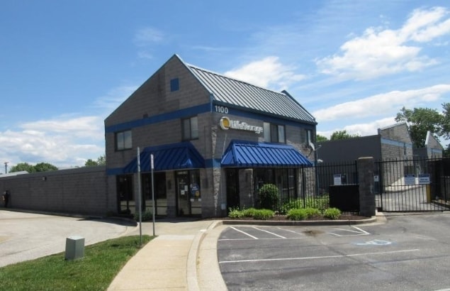
Property Record
1100 N North Point Rd, Dundalk, MD 21222

NEARBY LISTINGS FOR SALE OR LEASE
Property Detail
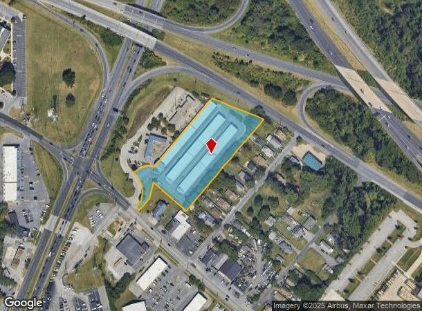
1100 N North Point Rd
Baltimore-Columbia-Towson, MD
Merritt Station
15-2200010919
4.329 ACS MERRITT STATION
Publicstorage
Baltimore
X
Maryland
2400100420H
1
2024
4.33 AC
2025
Baltimore County East
452400
Baltimore
74,000 SF
DEMOGRAPHICS near 1100 N North Point Rd
1 Mile
3 Mile
5 Mile
2024 Total Population
10,961
105,476
293,256
2029 Population
10,795
103,103
285,598
Pop Growth 2024-2029
(1.51%)
(2.25%)
(2.61%)
Average Age
39
39
39
2024 Total Households
3,695
39,362
116,489
HH Growth 2024-2029
(1.60%)
(2.34%)
(2.80%)
Median Household Inc
$66,373
$58,719
$61,542
Avg Household Size
2.80
2.60
2.40
2024 Avg HH Vehicles
2.00
2.00
1.00
Median Home Value
$157,489
$179,610
$204,385
Median Year Built
1953
1955
1954
Nearby Places
Map Layers
Map Styles
 Street
 Aerial
- Restaurants
- Banks
- Shops
- Fitness
- Groceries
PUBLIC TRANSPORTATION
COMMUTER RAIL
Martin State Airport (PENN - WASHINGTON - Maryland Area Regional Commuter Trains (The MARC), Penn Line - Maryland Area Regional Commuter Trains (The MARC))
DRIVE
WALK
Distance
Martin State Airport (PENN - WASHINGTON - Maryland Area Regional Commuter Trains (The MARC), Penn Line - Maryland Area Regional Commuter Trains (The MARC))
14 min
6.1 mi
Penn Station (PENN - WASHINGTON - Maryland Area Regional Commuter Trains (The MARC), Penn Line - Maryland Area Regional Commuter Trains (The MARC), Penn Station & Camden Yards - Maryland Area Regional Commuter Trains (The MARC))
DRIVE
WALK
Distance
Penn Station (PENN - WASHINGTON - Maryland Area Regional Commuter Trains (The MARC), Penn Line - Maryland Area Regional Commuter Trains (The MARC), Penn Station & Camden Yards - Maryland Area Regional Commuter Trains (The MARC))
18 min
7.5 mi
AIRPORT
Baltimore/Washington International Thurgood Marshall
DRIVE
WALK
Distance
Baltimore/Washington International Thurgood Marshall
29 min
17.5 mi
Freight Ports
Port of Baltimore
DRIVE
WALK
Distance
Port of Baltimore
16 min
7.9 mi
Nearby Properties
Address
Land Use
TOTAL SIZE
Lot Size
Zoning
Address
Land Use
TOTAL SIZE
Lot Size
Zoning
608,666 SF
8.42 AC
H
Address
Land Use
TOTAL SIZE
Lot Size
Zoning
268,543 SF
84.93 AC
H
Address
Land Use
TOTAL SIZE
Lot Size
Zoning
1,015,550 SF
64.95 AC
I-2
Address
Land Use
TOTAL SIZE
Lot Size
Zoning
475,525 SF
4.22 AC
C-3
Address
Land Use
TOTAL SIZE
Lot Size
Zoning
347,000 SF
42.73 AC
DR
Address
Land Use
TOTAL SIZE
Lot Size
Zoning
619,700 SF
34.98 AC
I-2
Address
Land Use
TOTAL SIZE
Lot Size
Zoning
278,006 SF
49.85 AC
DR
Address
Land Use
TOTAL SIZE
Lot Size
Zoning
413,345 SF
46.90 AC
I-2
Address
Land Use
TOTAL SIZE
Lot Size
Zoning
621,041 SF
32.69 AC
MH-IM
Address
Land Use
TOTAL SIZE
Lot Size
Zoning
33.65 AC
DR16
Address
Land Use
TOTAL SIZE
Lot Size
Zoning
126,507 SF
1.05 AC
H
Address
Land Use
TOTAL SIZE
Lot Size
Zoning
135,548 SF
13 AC
DR5.5
Address
Land Use
TOTAL SIZE
Lot Size
Zoning
227,772 SF
19.14 AC
2-1
Address
Land Use
TOTAL SIZE
Lot Size
Zoning
132,038 SF
5.38 AC
OIC
Address
Land Use
TOTAL SIZE
Lot Size
Zoning
346,408 SF
18.50 AC
I-2
Address
Land Use
TOTAL SIZE
Lot Size
Zoning
139.18 AC
MI
Address
Land Use
TOTAL SIZE
Lot Size
Zoning
97,784 SF
1.35 AC
DR10.
Address
Land Use
TOTAL SIZE
Lot Size
Zoning
342,500 SF
52.40 AC
I-2
Address
Land Use
TOTAL SIZE
Lot Size
Zoning
507,600 SF
21.36 AC
MHIM
Address
Land Use
TOTAL SIZE
Lot Size
Zoning
666,800 SF
17.50 AC
OIC
Address
Land Use
TOTAL SIZE
Lot Size
Zoning
91,535 SF
6.05 AC
I-2
Address
Land Use
TOTAL SIZE
Lot Size
Zoning
213,997 SF
45.22 AC
DR
Address
Land Use
TOTAL SIZE
Lot Size
Zoning
718,098 SF
83.20 AC
MH-IM
Address
Land Use
TOTAL SIZE
Lot Size
Zoning
13.72 AC
DR16
Address
Land Use
TOTAL SIZE
Lot Size
Zoning
82,800 SF
1.09 AC
C-3
Address
Land Use
TOTAL SIZE
Lot Size
Zoning
104,410 SF
3.85 AC
DR
Address
Land Use
TOTAL SIZE
Lot Size
Zoning
3,099 SF
16.10 AC
BM
Address
Land Use
TOTAL SIZE
Lot Size
Zoning
189,347 SF
28.24 AC
DR10
Address
Land Use
TOTAL SIZE
Lot Size
Zoning
28,963 SF
60.65 AC
BM-CT
Address
Land Use
TOTAL SIZE
Lot Size
Zoning
514,023 SF
11.99 AC
I-2
The World's #1 Commercial Real Estate Marketplace
Connect with us
© 2025 CoStar Group
The information above has been obtained from sources believed reliable. While we do not doubt its accuracy we have not verified it and make no guarantee, warranty or representation about it. It is your responsibility to independently confirm its accuracy and completeness. Any projections, opinions, assumptions, or estimates used are for example only and do not represent the current or future performance of the property. The value of this transaction to you depends on tax and other factors which should be evaluated by your tax, financial, and legal advisors. You and your advisors should conduct a careful, independent investigation of the property to determine to your satisfaction the suitability of the property for your needs.