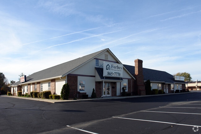
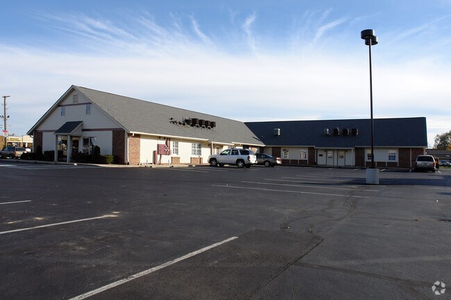
Property Record
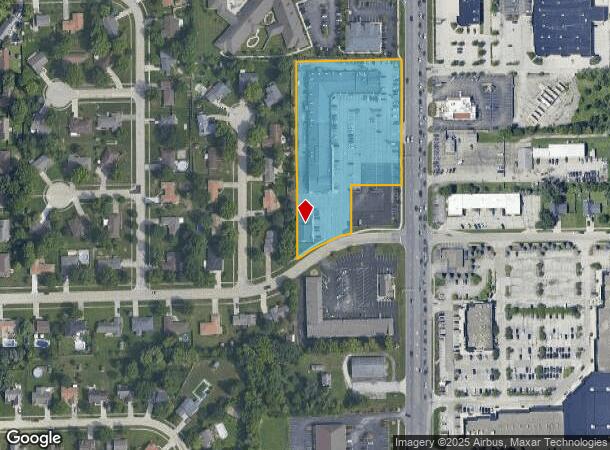
1100 N State Road 135, Greenwood, IN 46142
NEARBY LISTINGS FOR SALE OR LEASE
Property Detail
1100 N State Road 135
41-03-26-011-062.000-040
NE S26 T14 R3
Officebuilding
Johnson
X
Indiana
18081C0018E
0.97 AC
2024
Greenwood
2025
Indianapolis
610606
Indianapolis-Carmel-Anderson, IN
3,200 SF
DEMOGRAPHICS near 1100 N State Road 135
1 Mile
3 Mile
5 Mile
2024 Total Population
8,674
88,505
173,136
2029 Population
8,856
90,150
176,950
Pop Growth 2024-2029
+ 2.10%
+ 1.86%
+ 2.20%
Average Age
43
39
38
2024 Total Households
3,433
34,701
66,759
HH Growth 2024-2029
+ 2.04%
+ 1.92%
+ 2.25%
Median Household Inc
$73,492
$71,249
$73,209
Avg Household Size
2.40
2.50
2.50
2024 Avg HH Vehicles
2.00
2.00
2.00
Median Home Value
$193,518
$221,403
$216,447
Median Year Built
1978
1982
1987
Nearby Places
- Restaurants
- Banks
- Shops
- Fitness
- Groceries
PUBLIC TRANSPORTATION
COMMUTER RAIL
DRIVE
WALK
Distance
17 min
9.1 mi
AIRPORT
Indianapolis International
DRIVE
WALK
Distance
Indianapolis International
33 min
16.2 mi
Nearby Properties
Address
Land Use
TOTAL SIZE
Lot Size
Zoning
Address
Land Use
TOTAL SIZE
Lot Size
Zoning
295,161 SF
70.54 AC
Address
Land Use
TOTAL SIZE
Lot Size
Zoning
56,520 SF
35.65 AC
Address
Land Use
TOTAL SIZE
Lot Size
Zoning
3,286 SF
26.39 AC
Address
Land Use
TOTAL SIZE
Lot Size
Zoning
3,346 SF
21.35 AC
Address
Land Use
TOTAL SIZE
Lot Size
Zoning
5,279 SF
18.07 AC
ZO01
Address
Land Use
TOTAL SIZE
Lot Size
Zoning
3,782 SF
44.43 AC
ZO01
Address
Land Use
TOTAL SIZE
Lot Size
Zoning
21,784 SF
30.75 AC
ZO01
Address
Land Use
TOTAL SIZE
Lot Size
Zoning
2,911 SF
24.62 AC
ZO01
Address
Land Use
TOTAL SIZE
Lot Size
Zoning
23,040 SF
9.28 AC
ZO01
Address
Land Use
TOTAL SIZE
Lot Size
Zoning
4,478 SF
12.05 AC
Address
Land Use
TOTAL SIZE
Lot Size
Zoning
33,790 SF
13.01 AC
Address
Land Use
TOTAL SIZE
Lot Size
Zoning
226,129 SF
18.69 AC
ZO01
Address
Land Use
TOTAL SIZE
Lot Size
Zoning
3,818 SF
15.24 AC
Address
Land Use
TOTAL SIZE
Lot Size
Zoning
1,102 SF
9.98 AC
Address
Land Use
TOTAL SIZE
Lot Size
Zoning
5,779 SF
15.77 AC
Address
Land Use
TOTAL SIZE
Lot Size
Zoning
11,546 SF
14.18 AC
Address
Land Use
TOTAL SIZE
Lot Size
Zoning
3,935 SF
36.09 AC
ZO01
Address
Land Use
TOTAL SIZE
Lot Size
Zoning
3,793 SF
23.47 AC
ZO01
Address
Land Use
TOTAL SIZE
Lot Size
Zoning
2,320 SF
7.92 AC
ZO01
Address
Land Use
TOTAL SIZE
Lot Size
Zoning
4,476 SF
12.18 AC
Address
Land Use
TOTAL SIZE
Lot Size
Zoning
1,925 SF
29.98 AC
Address
Land Use
TOTAL SIZE
Lot Size
Zoning
3,337 SF
21.53 AC
ZO01
Address
Land Use
TOTAL SIZE
Lot Size
Zoning
3,296 SF
21 AC
Address
Land Use
TOTAL SIZE
Lot Size
Zoning
3,701 SF
26 AC
ZO01
Address
Land Use
TOTAL SIZE
Lot Size
Zoning
65,551 SF
12.84 AC
ZO01
Address
Land Use
TOTAL SIZE
Lot Size
Zoning
108,092 SF
23.62 AC
ZO01
Address
Land Use
TOTAL SIZE
Lot Size
Zoning
73,680 SF
5.62 AC
ZO01
Address
Land Use
TOTAL SIZE
Lot Size
Zoning
3,168 SF
8.62 AC
Address
Land Use
TOTAL SIZE
Lot Size
Zoning
152,664 SF
14.82 AC
Address
Land Use
TOTAL SIZE
Lot Size
Zoning
1,960 SF
23.76 AC
The World's #1 Commercial Real Estate Marketplace
Connect with us
© 2025 CoStar Group
The information above has been obtained from sources believed reliable. While we do not doubt its accuracy we have not verified it and make no guarantee, warranty or representation about it. It is your responsibility to independently confirm its accuracy and completeness. Any projections, opinions, assumptions, or estimates used are for example only and do not represent the current or future performance of the property. The value of this transaction to you depends on tax and other factors which should be evaluated by your tax, financial, and legal advisors. You and your advisors should conduct a careful, independent investigation of the property to determine to your satisfaction the suitability of the property for your needs.