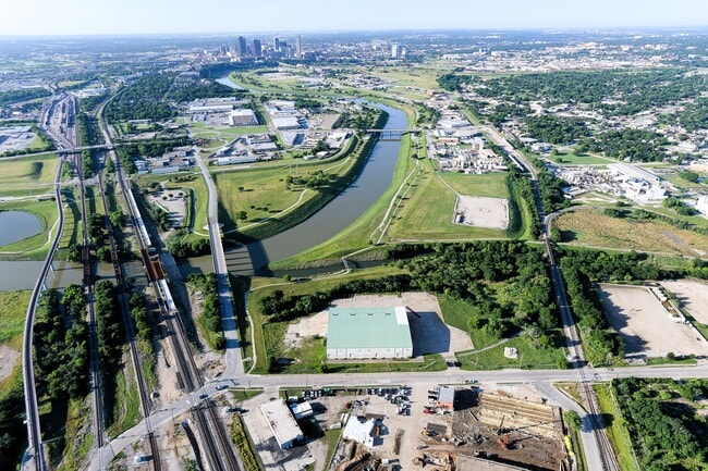
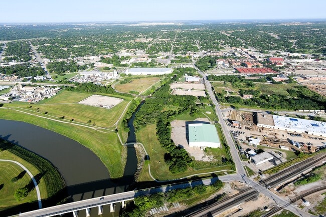
Property Record
1100 Ne 23Rd St, Fort Worth, TX 76164


Current Lease Availabilities
NEARBY LISTINGS FOR SALE OR LEASE
Property Detail
1100 Ne 23Rd St
Dallas-Fort Worth-Arlington, TX
Fort Worth Stockyards Co
06624219
FORT WORTH STOCKYARDS CO BLOCK 17 LOT 1
Industrialgeneral
Tarrant
AE
Texas
48439C0190L
1
2024
14.11 AC
2025
N Central Ft Worth
100202
Dallas/Ft Worth
45,900 SF
DEMOGRAPHICS near 1100 Ne 23Rd St
1 Mile
3 Mile
5 Mile
2024 Total Population
6,518
98,485
235,614
2029 Population
6,969
104,777
250,593
Pop Growth 2024-2029
+ 6.92%
+ 6.39%
+ 6.36%
Average Age
35
36
36
2024 Total Households
2,018
34,477
84,609
HH Growth 2024-2029
+ 7.53%
+ 7.09%
+ 6.78%
Median Household Inc
$43,443
$56,014
$57,653
Avg Household Size
3.10
2.60
2.60
2024 Avg HH Vehicles
2.00
2.00
2.00
Median Home Value
$128,647
$159,864
$199,768
Median Year Built
1953
1971
1970
Nearby Places
Map Layers
Map Styles
 Street
 Aerial
- Restaurants
- Banks
- Shops
- Fitness
- Groceries
PUBLIC TRANSPORTATION
COMMUTER RAIL
DRIVE
WALK
Distance
8 min
3.8 mi
Fort Worth Intermodal Transportation Center (ITC) (Trinity Railway Express - Dallas Area Rapid Transit (DART))
DRIVE
WALK
Distance
Fort Worth Intermodal Transportation Center (ITC) (Trinity Railway Express - Dallas Area Rapid Transit (DART))
8 min
3.8 mi
AIRPORT
Dallas-Fort Worth International
DRIVE
WALK
Distance
Dallas-Fort Worth International
35 min
25.9 mi
Dallas Love Field
DRIVE
WALK
Distance
Dallas Love Field
46 min
34.5 mi
Nearby Properties
Address
Land Use
TOTAL SIZE
Lot Size
Zoning
Address
Land Use
TOTAL SIZE
Lot Size
Zoning
133,700 SF
6.29 AC
Address
Land Use
TOTAL SIZE
Lot Size
Zoning
738,487 SF
2.11 AC
Address
Land Use
TOTAL SIZE
Lot Size
Zoning
1,009,233 SF
0.92 AC
Address
Land Use
TOTAL SIZE
Lot Size
Zoning
616,686 SF
2.82 AC
Address
Land Use
TOTAL SIZE
Lot Size
Zoning
773,033 SF
2.11 AC
Address
Land Use
TOTAL SIZE
Lot Size
Zoning
1,281,000 SF
1.15 AC
Address
Land Use
TOTAL SIZE
Lot Size
Zoning
551,198 SF
3.12 AC
Address
Land Use
TOTAL SIZE
Lot Size
Zoning
508,378 SF
6.02 AC
Address
Land Use
TOTAL SIZE
Lot Size
Zoning
650,744 SF
15.68 AC
Address
Land Use
TOTAL SIZE
Lot Size
Zoning
884,928 SF
1.01 AC
Address
Land Use
TOTAL SIZE
Lot Size
Zoning
205,807 SF
3.19 AC
Address
Land Use
TOTAL SIZE
Lot Size
Zoning
1,024,627 SF
0.83 AC
Address
Land Use
TOTAL SIZE
Lot Size
Zoning
764,691 SF
0.92 AC
Address
Land Use
TOTAL SIZE
Lot Size
Zoning
914,300 SF
3.46 AC
Address
Land Use
TOTAL SIZE
Lot Size
Zoning
774,327 SF
11.86 AC
Address
Land Use
TOTAL SIZE
Lot Size
Zoning
1,719,136 SF
18.18 AC
Address
Land Use
TOTAL SIZE
Lot Size
Zoning
586,500 SF
159.54 AC
Address
Land Use
TOTAL SIZE
Lot Size
Zoning
537,395 SF
2.82 AC
Address
Land Use
TOTAL SIZE
Lot Size
Zoning
788,621 SF
6.39 AC
Address
Land Use
TOTAL SIZE
Lot Size
Zoning
498,381 SF
5.26 AC
Address
Land Use
TOTAL SIZE
Lot Size
Zoning
750,215 SF
0.69 AC
Address
Land Use
TOTAL SIZE
Lot Size
Zoning
336,310 SF
2.85 AC
Address
Land Use
TOTAL SIZE
Lot Size
Zoning
487,426 SF
4.18 AC
Address
Land Use
TOTAL SIZE
Lot Size
Zoning
419,815 SF
10.26 AC
Address
Land Use
TOTAL SIZE
Lot Size
Zoning
581,601 SF
3.77 AC
Address
Land Use
TOTAL SIZE
Lot Size
Zoning
423,917 SF
4.20 AC
Address
Land Use
TOTAL SIZE
Lot Size
Zoning
462,036 SF
5.40 AC
Address
Land Use
TOTAL SIZE
Lot Size
Zoning
363,192 SF
2.62 AC
Address
Land Use
TOTAL SIZE
Lot Size
Zoning
699,246 SF
40.69 AC
Address
Land Use
TOTAL SIZE
Lot Size
Zoning
442,989 SF
7.15 AC
The World's #1 Commercial Real Estate Marketplace
Connect with us
© 2025 CoStar Group
The information above has been obtained from sources believed reliable. While we do not doubt its accuracy we have not verified it and make no guarantee, warranty or representation about it. It is your responsibility to independently confirm its accuracy and completeness. Any projections, opinions, assumptions, or estimates used are for example only and do not represent the current or future performance of the property. The value of this transaction to you depends on tax and other factors which should be evaluated by your tax, financial, and legal advisors. You and your advisors should conduct a careful, independent investigation of the property to determine to your satisfaction the suitability of the property for your needs.