Property Record
1100 Patrick Pike, Ferris, TX 75125

Save to a Folder
{{folder.Name}}
{{folder.ListingIds.length}} Properties
{{folder.ListingIds.length}} Property
Create a New Folder
This Property Is For Sale
Property Detail
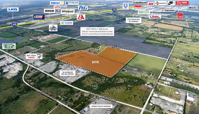
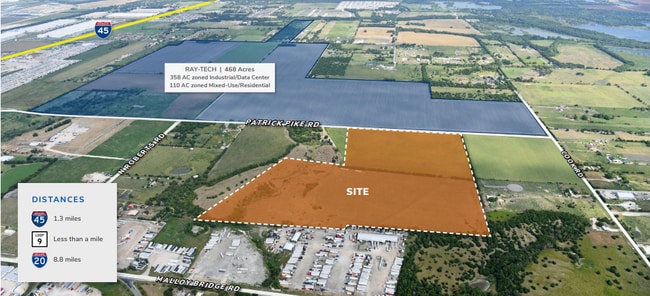
1100 Patrick Pike
65039410510010000
HARDIN W DENNY ABST 394 PG 105 TR 1 ACS 85.8334 HS ON 65039410510010001 INT201400208657 DD08152014 CO-DC 0394105100100 4NT03941051
Privatepreserveopenspacevacantlandforestlandconservation
DALLAS
Z05
Texas
B and X Area of moderate flood hazard, usually the area between the limits of the 100-year and 500-year floods.
85.83 AC
2025
Mesquite/Forney/Terrell
2025
Dallas/Ft Worth
060104
Dallas-Fort Worth-Arlington, TX
NEARBY LISTINGS FOR SALE OR LEASE
DEMOGRAPHICS near 1100 Patrick Pike
1 mile
3 mile
5 mile
2025 Total Population
141
5,785
14,773
2030 Population
153
6,396
16,520
Pop Growth 2025-2030
+ 8.51%
+ 10.56%
+ 11.83%
Average Age
33
34
36
2025 Total Households
42
1,793
4,671
HH Growth 2025-2030
+ 9.52%
+ 10.93%
+ 12.12%
Median Household Inc
$66,964
$64,024
$64,011
Avg Household Size
3.30
3.20
3.10
2025 Avg HH Vehicles
2.00
2.00
2.00
Median Home Value
$154,545
$160,747
$201,067
Median Year Built
2003
1994
1995
Nearby Places
Map Layers
Map Styles
 Street
 Aerial
Layers
 Traffic
 Biking
Places
Listings with unknown addresses are not visible on the map
- Restaurants
- Banks
- Shops
- Fitness
- Groceries
PUBLIC TRANSPORTATION
AIRPORT
Dallas Love Field
Drive
Walk
Distance
Dallas Love Field
36 min
24.1 mi
Freight Ports
Port of Shreveport
Drive
Walk
Distance
Port of Shreveport
214 min
190.9 mi
Nearby Properties
Address
Land Use
TOTAL SIZE
Lot Size
Zoning
Address
Land Use
TOTAL SIZE
Lot Size
Zoning
62.41 AC
Z31
Address
Land Use
TOTAL SIZE
Lot Size
Zoning
Address
Land Use
TOTAL SIZE
Lot Size
Zoning
1,409,184 SF
75.72 AC
Z31
Address
Land Use
TOTAL SIZE
Lot Size
Zoning
1,021,601 SF
79.42 AC
Z268
Address
Land Use
TOTAL SIZE
Lot Size
Zoning
1,020,000 SF
56.30 AC
Z31
Address
Land Use
TOTAL SIZE
Lot Size
Zoning
660,000 SF
39.24 AC
Z31
Address
Land Use
TOTAL SIZE
Lot Size
Zoning
750,000 SF
37.12 AC
Z31
Address
Land Use
TOTAL SIZE
Lot Size
Zoning
570,000 SF
30.48 AC
Z251
Address
Land Use
TOTAL SIZE
Lot Size
Zoning
565,259 SF
38.69 AC
Z123
Address
Land Use
TOTAL SIZE
Lot Size
Zoning
481,520 SF
26.82 AC
Z31
Address
Land Use
TOTAL SIZE
Lot Size
Zoning
431,190 SF
46.46 AC
Z251
Address
Land Use
TOTAL SIZE
Lot Size
Zoning
202,439 SF
12.48 AC
Z31
Address
Land Use
TOTAL SIZE
Lot Size
Zoning
392,066 SF
23.52 AC
Address
Land Use
TOTAL SIZE
Lot Size
Zoning
266,199 SF
33.27 AC
Address
Land Use
TOTAL SIZE
Lot Size
Zoning
334,800 SF
18.16 AC
Z251
Address
Land Use
TOTAL SIZE
Lot Size
Zoning
370,139 SF
15.42 AC
Z268
Address
Land Use
TOTAL SIZE
Lot Size
Zoning
376,368 SF
19.42 AC
Z31
Address
Land Use
TOTAL SIZE
Lot Size
Zoning
80,980 SF
15.18 AC
AG
Address
Land Use
TOTAL SIZE
Lot Size
Zoning
174,802 SF
8.67 AC
Address
Land Use
TOTAL SIZE
Lot Size
Zoning
235,368 SF
21.03 AC
Z05
Address
Land Use
TOTAL SIZE
Lot Size
Zoning
143,771 SF
130.33 AC
Z123
Address
Land Use
TOTAL SIZE
Lot Size
Zoning
100 AC
Address
Land Use
TOTAL SIZE
Lot Size
Zoning
97,372 SF
42.82 AC
Z31
Address
Land Use
TOTAL SIZE
Lot Size
Zoning
12,444 SF
5 AC
Address
Land Use
TOTAL SIZE
Lot Size
Zoning
125.51 AC
Z05
Address
Land Use
TOTAL SIZE
Lot Size
Zoning
74.27 AC
Z123
Address
Land Use
TOTAL SIZE
Lot Size
Zoning
84.71 AC
Z268
Address
Land Use
TOTAL SIZE
Lot Size
Zoning
1,400 SF
75.81 AC
Z05
Address
Land Use
TOTAL SIZE
Lot Size
Zoning
53,610 SF
15 AC
Z31
Address
Land Use
TOTAL SIZE
Lot Size
Zoning
110 SF
12.35 AC
Z31
The World's #1 Commercial Real Estate Marketplace
Connect with us
© 2026 CoStar Group
The information above has been obtained from sources believed reliable. While we do not doubt its accuracy we have not verified it and make no guarantee, warranty or representation about it. It is your responsibility to independently confirm its accuracy and completeness. Any projections, opinions, assumptions, or estimates used are for example only and do not represent the current or future performance of the property. The value of this transaction to you depends on tax and other factors which should be evaluated by your tax, financial, and legal advisors. You and your advisors should conduct a careful, independent investigation of the property to determine to your satisfaction the suitability of the property for your needs.