Property Record
W 11Th St S, Tulsa, OK 74127
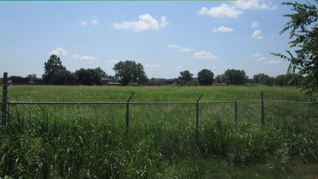
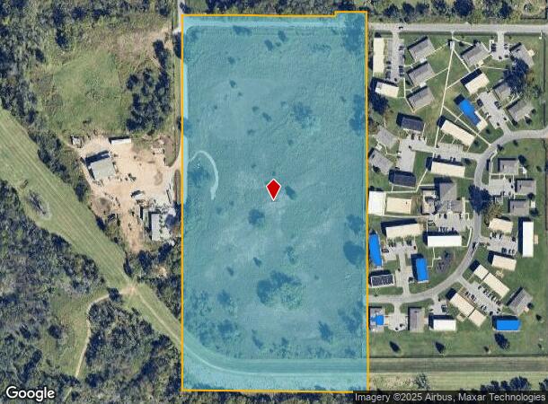
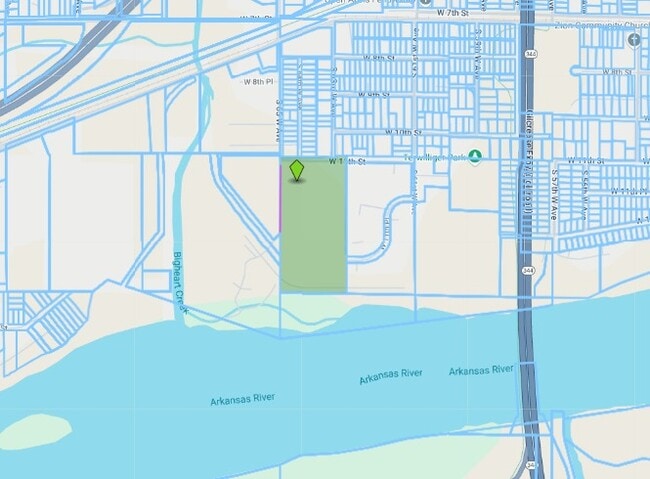
This Property Is For Sale
NEARBY LISTINGS FOR SALE OR LEASE
-
-
View all Tulsa listings for sale on LoopNet.com
Property Detail
W 11Th St S
Tulsa, OK
Unplatted
99208-92-08-08680
W647.8 SW NW SEC 8 19 12 19.63ACS
Commercialacreage
Tulsa
AE
Oklahoma
40113C1240K
19.63 AC
2025
West
2025
Tulsa
940005
DEMOGRAPHICS near W 11Th St S
1 Mile
3 Mile
5 Mile
2024 Total Population
4,337
19,851
70,831
2029 Population
4,608
20,745
73,801
Pop Growth 2024-2029
+ 6.25%
+ 4.50%
+ 4.19%
Average Age
38
40
40
2024 Total Households
1,782
8,041
30,232
HH Growth 2024-2029
+ 6.17%
+ 4.56%
+ 4.52%
Median Household Inc
$42,078
$50,132
$51,996
Avg Household Size
2.40
2.40
2.20
2024 Avg HH Vehicles
2.00
2.00
2.00
Median Home Value
$66,778
$122,402
$149,637
Median Year Built
1959
1959
1966
Nearby Places
Map Layers
Map Styles
 Street
 Aerial
- Restaurants
- Banks
- Shops
- Fitness
- Groceries
PUBLIC TRANSPORTATION
AIRPORT
Tulsa International
DRIVE
WALK
Distance
Tulsa International
22 min
13.9 mi
Freight Ports
Tulsa Port Of Catoosa
DRIVE
WALK
Distance
Tulsa Port Of Catoosa
32 min
23.2 mi
Nearby Properties
Address
Land Use
TOTAL SIZE
Lot Size
Zoning
Address
Land Use
TOTAL SIZE
Lot Size
Zoning
92,076 SF
81.28 AC
IM
Address
Land Use
TOTAL SIZE
Lot Size
Zoning
157,736 SF
56.74 AC
RS3
Address
Land Use
TOTAL SIZE
Lot Size
Zoning
174,776 SF
9.46 AC
RM2
Address
Land Use
TOTAL SIZE
Lot Size
Zoning
101,827 SF
30.64 AC
RS1
Address
Land Use
TOTAL SIZE
Lot Size
Zoning
15,747 SF
2.50 AC
CM
Address
Land Use
TOTAL SIZE
Lot Size
Zoning
1,123,266 SF
87.29 AC
IM
Address
Land Use
TOTAL SIZE
Lot Size
Zoning
32,827 SF
4.22 AC
CS
Address
Land Use
TOTAL SIZE
Lot Size
Zoning
40,003 SF
6.03 AC
IM
Address
Land Use
TOTAL SIZE
Lot Size
Zoning
46,878 SF
4.99 AC
Address
Land Use
TOTAL SIZE
Lot Size
Zoning
22,078 SF
5.08 AC
CS
Address
Land Use
TOTAL SIZE
Lot Size
Zoning
108,279 SF
6.38 AC
AG
Address
Land Use
TOTAL SIZE
Lot Size
Zoning
28,240 SF
147.33 AC
NCU
Address
Land Use
TOTAL SIZE
Lot Size
Zoning
21,170 SF
0.17 AC
CH
Address
Land Use
TOTAL SIZE
Lot Size
Zoning
81,444 SF
1.19 AC
RS3
Address
Land Use
TOTAL SIZE
Lot Size
Zoning
46,452 SF
9.64 AC
CS
Address
Land Use
TOTAL SIZE
Lot Size
Zoning
108,900 SF
6.82 AC
IM
Address
Land Use
TOTAL SIZE
Lot Size
Zoning
51,678 SF
5.14 AC
RS1
Address
Land Use
TOTAL SIZE
Lot Size
Zoning
197,063 SF
11.23 AC
RM2
Address
Land Use
TOTAL SIZE
Lot Size
Zoning
70,910 SF
6.73 AC
IM
Address
Land Use
TOTAL SIZE
Lot Size
Zoning
631,551 SF
47.19 AC
IM
Address
Land Use
TOTAL SIZE
Lot Size
Zoning
31,783 SF
9.65 AC
RS3
Address
Land Use
TOTAL SIZE
Lot Size
Zoning
27,426 SF
9 AC
RE
Address
Land Use
TOTAL SIZE
Lot Size
Zoning
25,685 SF
5.04 AC
Address
Land Use
TOTAL SIZE
Lot Size
Zoning
28,347 SF
2.07 AC
RS
Address
Land Use
TOTAL SIZE
Lot Size
Zoning
402,842 SF
449.67 AC
IH
Address
Land Use
TOTAL SIZE
Lot Size
Zoning
435,396 SF
12.36 AC
IM
Address
Land Use
TOTAL SIZE
Lot Size
Zoning
24,233 SF
1.50 AC
RM2
Address
Land Use
TOTAL SIZE
Lot Size
Zoning
11,988 SF
0.43 AC
CH
Address
Land Use
TOTAL SIZE
Lot Size
Zoning
17,801 SF
21.15 AC
IM
The World's #1 Commercial Real Estate Marketplace
Connect with us
© 2025 CoStar Group
The information above has been obtained from sources believed reliable. While we do not doubt its accuracy we have not verified it and make no guarantee, warranty or representation about it. It is your responsibility to independently confirm its accuracy and completeness. Any projections, opinions, assumptions, or estimates used are for example only and do not represent the current or future performance of the property. The value of this transaction to you depends on tax and other factors which should be evaluated by your tax, financial, and legal advisors. You and your advisors should conduct a careful, independent investigation of the property to determine to your satisfaction the suitability of the property for your needs.