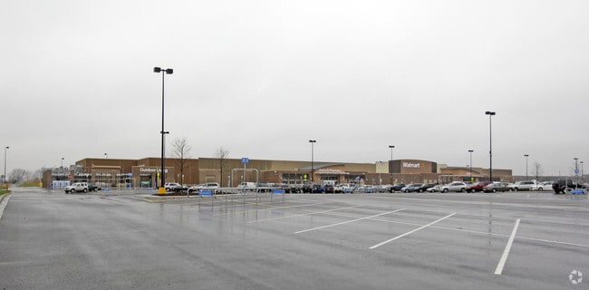
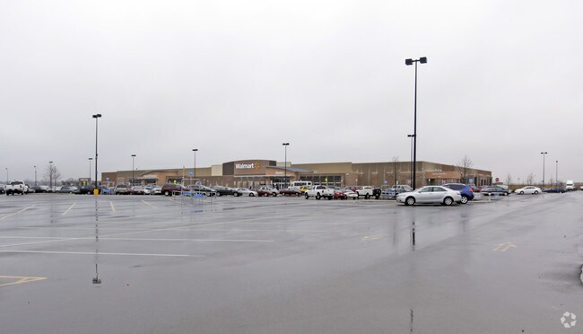
Property Record
1100 S Randall Rd, Elgin, IL 60123

Save to a Folder
{{folder.Name}}
{{folder.ListingIds.length}} Properties
{{folder.ListingIds.length}} Property
Create a New Folder
Property Detail
1100 S Randall Rd
Chicago-Naperville-Elgin, IL-IN
ELGIN WAL-MART/SAMS CLUB SUB LT 6
06-28-351-001
Kane
Commercialnec
Illinois
C and X Area of minimal flood hazard, usually depicted on FIRMs as above the 500-year flood level.
6
2024
19.48 AC
2024
Western East/West Corr
851912
Chicago
186,692 SF
NEARBY LISTINGS FOR SALE OR LEASE
DEMOGRAPHICS near 1100 S Randall Rd
1 mile
3 mile
5 mile
2025 Total Population
9,788
70,520
142,331
2030 Population
9,769
71,356
143,786
Pop Growth 2025-2030
(0.19%)
+ 1.19%
+ 1.02%
Average Age
43
40
39
2025 Total Households
3,671
23,998
48,192
HH Growth 2025-2030
(0.22%)
+ 1.17%
+ 0.98%
Median Household Inc
$109,514
$116,446
$103,866
Avg Household Size
2.60
2.90
2.90
2025 Avg HH Vehicles
2.00
2.00
2.00
Median Home Value
$330,833
$343,735
$324,855
Median Year Built
1999
1993
1984
Nearby Places
Map Layers
Map Styles
 Street
 Aerial
Layers
 Traffic
 Biking
Places
Listings with unknown addresses are not visible on the map
- Restaurants
- Banks
- Shops
- Fitness
- Groceries
PUBLIC TRANSPORTATION
COMMUTER RAIL
National Street Station (Milwaukee District West Line - Northeast Illinois Regional Commuter Railroad (Metra))
Drive
Walk
Distance
National Street Station (Milwaukee District West Line - Northeast Illinois Regional Commuter Railroad (Metra))
12 min
6.0 mi
Elgin Station (Milwaukee District West Line - Northeast Illinois Regional Commuter Railroad (Metra))
Drive
Walk
Distance
Elgin Station (Milwaukee District West Line - Northeast Illinois Regional Commuter Railroad (Metra))
11 min
6.2 mi
AIRPORT
Chicago O'Hare International
Drive
Walk
Distance
Chicago O'Hare International
44 min
33.7 mi
Freight Ports
Port Milwaukee
Drive
Walk
Distance
Port Milwaukee
123 min
90.0 mi
Nearby Properties
Address
Land Use
TOTAL SIZE
Lot Size
Zoning
Address
Land Use
TOTAL SIZE
Lot Size
Zoning
15.31 AC
Address
Land Use
TOTAL SIZE
Lot Size
Zoning
Address
Land Use
TOTAL SIZE
Lot Size
Zoning
Address
Land Use
TOTAL SIZE
Lot Size
Zoning
4.08 AC
Address
Land Use
TOTAL SIZE
Lot Size
Zoning
238,115 SF
21.61 AC
Address
Land Use
TOTAL SIZE
Lot Size
Zoning
8,012 SF
6.56 AC
Address
Land Use
TOTAL SIZE
Lot Size
Zoning
76,884 SF
2.87 AC
Address
Land Use
TOTAL SIZE
Lot Size
Zoning
5,596 SF
15.30 AC
Address
Land Use
TOTAL SIZE
Lot Size
Zoning
30,000 SF
9.96 AC
Address
Land Use
TOTAL SIZE
Lot Size
Zoning
142,044 SF
14.98 AC
Address
Land Use
TOTAL SIZE
Lot Size
Zoning
Address
Land Use
TOTAL SIZE
Lot Size
Zoning
5.44 AC
Address
Land Use
TOTAL SIZE
Lot Size
Zoning
175,152 SF
14.30 AC
Address
Land Use
TOTAL SIZE
Lot Size
Zoning
103,536 SF
17.71 AC
Address
Land Use
TOTAL SIZE
Lot Size
Zoning
Address
Land Use
TOTAL SIZE
Lot Size
Zoning
134,434 SF
8.83 AC
Address
Land Use
TOTAL SIZE
Lot Size
Zoning
61,720 SF
10.02 AC
Address
Land Use
TOTAL SIZE
Lot Size
Zoning
14.40 AC
Address
Land Use
TOTAL SIZE
Lot Size
Zoning
106,421 SF
10.76 AC
Address
Land Use
TOTAL SIZE
Lot Size
Zoning
160,680 SF
13.71 AC
Address
Land Use
TOTAL SIZE
Lot Size
Zoning
17,680 SF
5.63 AC
Address
Land Use
TOTAL SIZE
Lot Size
Zoning
119,590 SF
12.08 AC
Address
Land Use
TOTAL SIZE
Lot Size
Zoning
11,972 SF
10 AC
Address
Land Use
TOTAL SIZE
Lot Size
Zoning
104,510 SF
9.54 AC
Address
Land Use
TOTAL SIZE
Lot Size
Zoning
7.83 AC
Address
Land Use
TOTAL SIZE
Lot Size
Zoning
Address
Land Use
TOTAL SIZE
Lot Size
Zoning
55,905 SF
5.36 AC
Address
Land Use
TOTAL SIZE
Lot Size
Zoning
136,280 SF
9.18 AC
The World's #1 Commercial Real Estate Marketplace
Connect with us
© 2026 CoStar Group
The information above has been obtained from sources believed reliable. While we do not doubt its accuracy we have not verified it and make no guarantee, warranty or representation about it. It is your responsibility to independently confirm its accuracy and completeness. Any projections, opinions, assumptions, or estimates used are for example only and do not represent the current or future performance of the property. The value of this transaction to you depends on tax and other factors which should be evaluated by your tax, financial, and legal advisors. You and your advisors should conduct a careful, independent investigation of the property to determine to your satisfaction the suitability of the property for your needs.