Property Record
1100 Se Rice Rd, Topeka, KS 66607
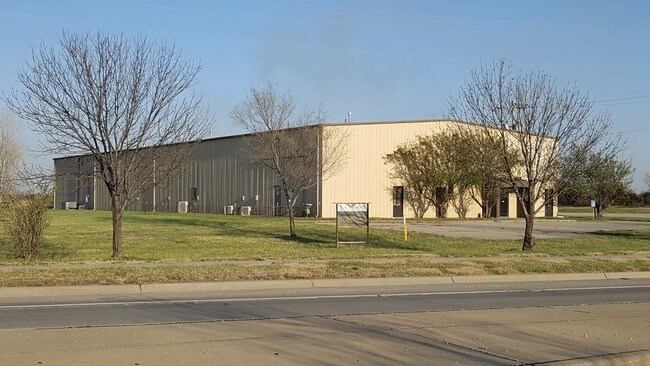


Property Detail
1100 Se Rice Rd
132-03-0-40-01-003-010
TOPEKA TURNPIKE INDUST , BLOCK A , LOT 1 , BEG NW COR LT 1 E 400.11 S 556.32 W 370.37 NLY 72.15 N 483.11 TO POB LESS ROW SECTION 03 TOWNSHIP 12 RANGE 16
Lumberwoodproductmanufacturingincludingfurniture
Shawnee
PUD,I1
Kansas
B and X Area of moderate flood hazard, usually the area between the limits of the 100-year and 500-year floods.
1
2024
2.84 AC
2025
Topeka
003100
Kansas City
14,000 SF
Topeka, KS
NEARBY LISTINGS FOR SALE OR LEASE
DEMOGRAPHICS near 1100 Se Rice Rd
1 mile
3 mile
5 mile
2025 Total Population
3,844
34,434
86,810
2030 Population
3,900
34,520
87,535
Pop Growth 2025-2030
+ 1.46%
+ 0.25%
+ 0.84%
Average Age
38
39
39
2025 Total Households
1,081
12,910
34,714
HH Growth 2025-2030
+ 1.85%
+ 0.25%
+ 0.96%
Median Household Inc
$67,302
$49,361
$51,874
Avg Household Size
2.60
2.50
2.30
2025 Avg HH Vehicles
2.00
2.00
2.00
Median Home Value
$150,362
$118,709
$124,516
Median Year Built
1974
1963
1960
Nearby Places
Map Layers
Map Styles
 Street
 Aerial
Layers
 Traffic
 Biking
Places
Listings with unknown addresses are not visible on the map
- Restaurants
- Banks
- Shops
- Fitness
- Groceries
PUBLIC TRANSPORTATION
COMMUTER RAIL
Topeka Amtrak Station (Southwest Chief - Amtrak)
Drive
Walk
Distance
Topeka Amtrak Station (Southwest Chief - Amtrak)
7 min
4.0 mi
Freight Ports
Tulsa Port Of Catoosa
Drive
Walk
Distance
Tulsa Port Of Catoosa
277 min
233.7 mi
SALE & LEASE HISTORY
LISTING DATE
SALE/LEASE

Feb 04, 2021
For Sale
Apr 24, 2018
For Sale
Nearby Properties
Address
Land Use
TOTAL SIZE
Lot Size
Zoning
Address
Land Use
TOTAL SIZE
Lot Size
Zoning
65,687 SF
7.47 AC
C2,I1,M2
Address
Land Use
TOTAL SIZE
Lot Size
Zoning
181,781 SF
569.17 AC
R1
Address
Land Use
TOTAL SIZE
Lot Size
Zoning
127,947 SF
7.12 AC
C5
Address
Land Use
TOTAL SIZE
Lot Size
Zoning
54,654 SF
0.56 AC
C5
Address
Land Use
TOTAL SIZE
Lot Size
Zoning
101,766 SF
2.39 AC
C5,I1
Address
Land Use
TOTAL SIZE
Lot Size
Zoning
101,166 SF
3.31 AC
C5
Address
Land Use
TOTAL SIZE
Lot Size
Zoning
165,001 SF
24.83 AC
R1
Address
Land Use
TOTAL SIZE
Lot Size
Zoning
161,335 SF
37.32 AC
R1
Address
Land Use
TOTAL SIZE
Lot Size
Zoning
92,118 SF
10.87 AC
R2
Address
Land Use
TOTAL SIZE
Lot Size
Zoning
61,680 SF
2.20 AC
C5
Address
Land Use
TOTAL SIZE
Lot Size
Zoning
188,606 SF
8.42 AC
I1
Address
Land Use
TOTAL SIZE
Lot Size
Zoning
51,514 SF
1.87 AC
I2
Address
Land Use
TOTAL SIZE
Lot Size
Zoning
50,453 SF
14.29 AC
PUD,M2
Address
Land Use
TOTAL SIZE
Lot Size
Zoning
75,691 SF
5.91 AC
M1,M2
Address
Land Use
TOTAL SIZE
Lot Size
Zoning
69,020 SF
26.47 AC
RR1
Address
Land Use
TOTAL SIZE
Lot Size
Zoning
47,037 SF
8 AC
R2
Address
Land Use
TOTAL SIZE
Lot Size
Zoning
34,310 SF
6.01 AC
OI2
Address
Land Use
TOTAL SIZE
Lot Size
Zoning
60,498 SF
1.02 AC
C5
Address
Land Use
TOTAL SIZE
Lot Size
Zoning
96,600 SF
23.56 AC
R1
Address
Land Use
TOTAL SIZE
Lot Size
Zoning
28,978 SF
2.90 AC
PUD,M3
Address
Land Use
TOTAL SIZE
Lot Size
Zoning
38,866 SF
9.40 AC
R1
Address
Land Use
TOTAL SIZE
Lot Size
Zoning
99,149 SF
14.97 AC
PUD,M1
Address
Land Use
TOTAL SIZE
Lot Size
Zoning
44,619 SF
4.35 AC
R1,R2
Address
Land Use
TOTAL SIZE
Lot Size
Zoning
55,329 SF
19.45 AC
RR1
Address
Land Use
TOTAL SIZE
Lot Size
Zoning
36,240 SF
0.25 AC
C5
Address
Land Use
TOTAL SIZE
Lot Size
Zoning
24,462 SF
40.76 AC
OS1
Address
Land Use
TOTAL SIZE
Lot Size
Zoning
61,755 SF
15.30 AC
RR1
Address
Land Use
TOTAL SIZE
Lot Size
Zoning
66,474 SF
9.33 AC
RR1
Address
Land Use
TOTAL SIZE
Lot Size
Zoning
33,196 SF
0.69 AC
C5
Address
Land Use
TOTAL SIZE
Lot Size
Zoning
35,335 SF
3.08 AC
PUD,C2
The World's #1 Commercial Real Estate Marketplace
Connect with us
© 2026 CoStar Group
The information above has been obtained from sources believed reliable. While we do not doubt its accuracy we have not verified it and make no guarantee, warranty or representation about it. It is your responsibility to independently confirm its accuracy and completeness. Any projections, opinions, assumptions, or estimates used are for example only and do not represent the current or future performance of the property. The value of this transaction to you depends on tax and other factors which should be evaluated by your tax, financial, and legal advisors. You and your advisors should conduct a careful, independent investigation of the property to determine to your satisfaction the suitability of the property for your needs.