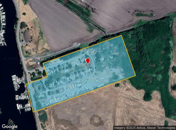
Property Record
1100 W Brannan Island Rd, Isleton, CA 95641
NEARBY LISTINGS FOR SALE OR LEASE
Property Detail
1100 W Brannan Island Rd
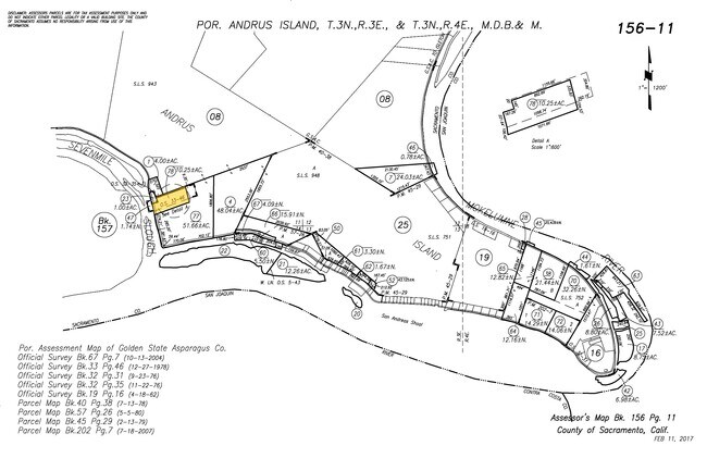
156-0110-078
A PORTION OF SECTION 11, T.3N., R.3E., M.D.B. & M., ANDRUS ISLAND, SACRAMENTO COUNTY, RECORDED IN BOOK 33 OF SURVEYS AT PAGE 46 MORE PARTICULARLY DESCRIBED AS FOLLOWS: BEGINNING AT A 2 INCH PIPE IN CONCRETE MARKING THE SOUTHEASTERLY CORNER
Marinafacility
Sacramento
AE
California
06067C0705H
10.25 AC
2024
Outer Sacramento County
2025
Sacramento
009800
Sacramento--Roseville--Arden-Arcade, CA
19,998 SF
DEMOGRAPHICS near 1100 W Brannan Island Rd
1 Mile
3 Mile
5 Mile
2024 Total Population
317
963
1,917
2029 Population
309
934
1,844
Pop Growth 2024-2029
(2.52%)
(3.01%)
(3.81%)
Average Age
53
51
48
2024 Total Households
183
510
896
HH Growth 2024-2029
(2.73%)
(2.94%)
(3.68%)
Median Household Inc
$28,863
$36,847
$48,431
Avg Household Size
1.80
1.90
2.10
2024 Avg HH Vehicles
2.00
2.00
2.00
Median Home Value
$585,937
$576,815
$590,909
Median Year Built
1990
1981
1977
Nearby Places
Map Layers
Map Styles
 Street
 Aerial
- Restaurants
- Banks
- Shops
- Fitness
- Groceries
PUBLIC TRANSPORTATION
AIRPORT
Stockton Metro
DRIVE
WALK
Distance
Stockton Metro
50 min
35.3 mi
Freight Ports
Port of Stockton
DRIVE
WALK
Distance
Port of Stockton
40 min
27.8 mi
Nearby Properties
Address
Land Use
TOTAL SIZE
Lot Size
Zoning
Address
Land Use
TOTAL SIZE
Lot Size
Zoning
153,371 SF
15.46 AC
C-O
Address
Land Use
TOTAL SIZE
Lot Size
Zoning
530.29 AC
AG-80
Address
Land Use
TOTAL SIZE
Lot Size
Zoning
628.94 AC
AG-80
Address
Land Use
TOTAL SIZE
Lot Size
Zoning
AG80 F
Address
Land Use
TOTAL SIZE
Lot Size
Zoning
513.57 AC
AG-80
Address
Land Use
TOTAL SIZE
Lot Size
Zoning
495.61 AC
AG-80
Address
Land Use
TOTAL SIZE
Lot Size
Zoning
Address
Land Use
TOTAL SIZE
Lot Size
Zoning
378.70 AC
SPA AG-80
Address
Land Use
TOTAL SIZE
Lot Size
Zoning
475.67 AC
A2
Address
Land Use
TOTAL SIZE
Lot Size
Zoning
349.12 AC
AG-80 SPA
Address
Land Use
TOTAL SIZE
Lot Size
Zoning
374.77 AC
AG40
Address
Land Use
TOTAL SIZE
Lot Size
Zoning
2,070 SF
333 AC
AG40
Address
Land Use
TOTAL SIZE
Lot Size
Zoning
Address
Land Use
TOTAL SIZE
Lot Size
Zoning
1,381 SF
8.80 AC
DW
Address
Land Use
TOTAL SIZE
Lot Size
Zoning
377.90 AC
A2
Address
Land Use
TOTAL SIZE
Lot Size
Zoning
Address
Land Use
TOTAL SIZE
Lot Size
Zoning
339.78 AC
A2
Address
Land Use
TOTAL SIZE
Lot Size
Zoning
339.52 AC
A2
Address
Land Use
TOTAL SIZE
Lot Size
Zoning
Address
Land Use
TOTAL SIZE
Lot Size
Zoning
315.82 AC
A2
Address
Land Use
TOTAL SIZE
Lot Size
Zoning
Address
Land Use
TOTAL SIZE
Lot Size
Zoning
6,431 SF
7.82 AC
DW
Address
Land Use
TOTAL SIZE
Lot Size
Zoning
206.31 AC
AG-80
Address
Land Use
TOTAL SIZE
Lot Size
Zoning
198 AC
SPA AG-80
Address
Land Use
TOTAL SIZE
Lot Size
Zoning
Address
Land Use
TOTAL SIZE
Lot Size
Zoning
Address
Land Use
TOTAL SIZE
Lot Size
Zoning
6.90 AC
DW-R
Address
Land Use
TOTAL SIZE
Lot Size
Zoning
24.03 AC
SPA
Address
Land Use
TOTAL SIZE
Lot Size
Zoning
200 AC
A2
Address
Land Use
TOTAL SIZE
Lot Size
Zoning
195.48 AC
A2
The World's #1 Commercial Real Estate Marketplace
Connect with us
© 2025 CoStar Group
The information above has been obtained from sources believed reliable. While we do not doubt its accuracy we have not verified it and make no guarantee, warranty or representation about it. It is your responsibility to independently confirm its accuracy and completeness. Any projections, opinions, assumptions, or estimates used are for example only and do not represent the current or future performance of the property. The value of this transaction to you depends on tax and other factors which should be evaluated by your tax, financial, and legal advisors. You and your advisors should conduct a careful, independent investigation of the property to determine to your satisfaction the suitability of the property for your needs.