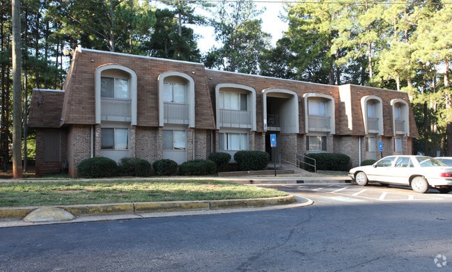
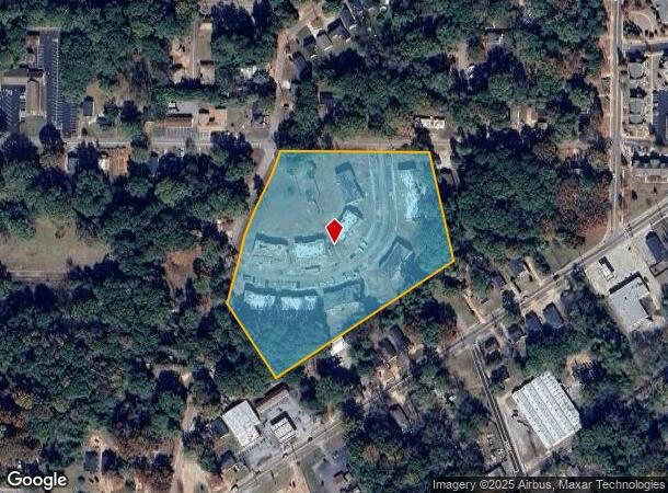
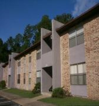
Property Record
1100 W College Ext, Griffin, GA 30224
NEARBY LISTINGS FOR SALE OR LEASE
-
-
View all Griffin listings for sale on LoopNet.com
Property Detail
1100 W College Ext
Atlanta-Sandy Springs-Roswell, GA
Mcwilliams
051-03-028
LTS 28-39 & PTS 40-42 BLK A W COLLEGE ST EXT
Apartment
Spalding
X
Georgia
13255C0185D
ml
2024
7.03 AC
2024
Spalding County
160701
Atlanta
21,984 SF
DEMOGRAPHICS near 1100 W College Ext
1 Mile
3 Mile
5 Mile
2024 Total Population
6,411
34,781
48,837
2029 Population
6,815
36,956
51,915
Pop Growth 2024-2029
+ 6.30%
+ 6.25%
+ 6.30%
Average Age
36
38
38
2024 Total Households
2,457
13,189
18,395
HH Growth 2024-2029
+ 6.23%
+ 6.17%
+ 6.22%
Median Household Inc
$24,970
$45,550
$49,686
Avg Household Size
2.50
2.50
2.60
2024 Avg HH Vehicles
1.00
2.00
2.00
Median Home Value
$121,575
$163,693
$169,391
Median Year Built
1970
1975
1978
Nearby Places
Map Layers
Map Styles
 Street
 Aerial
- Restaurants
- Banks
- Shops
- Fitness
- Groceries
PUBLIC TRANSPORTATION
AIRPORT
Hartsfield - Jackson Atlanta International
DRIVE
WALK
Distance
Hartsfield - Jackson Atlanta International
51 min
31.7 mi
Freight Ports
Georgia Ports - Savannah
DRIVE
WALK
Distance
Georgia Ports - Savannah
248 min
218.8 mi
Nearby Properties
Address
Land Use
TOTAL SIZE
Lot Size
Zoning
Address
Land Use
TOTAL SIZE
Lot Size
Zoning
210,196 SF
14.92 AC
PCD
Address
Land Use
TOTAL SIZE
Lot Size
Zoning
112,554 SF
40.27 AC
C2
Address
Land Use
TOTAL SIZE
Lot Size
Zoning
46,074 SF
30.36 AC
OI
Address
Land Use
TOTAL SIZE
Lot Size
Zoning
56,415 SF
0.56 AC
PCD
Address
Land Use
TOTAL SIZE
Lot Size
Zoning
200,880 SF
21.14 AC
PCD
Address
Land Use
TOTAL SIZE
Lot Size
Zoning
2,876 SF
19.98 AC
HDRB
Address
Land Use
TOTAL SIZE
Lot Size
Zoning
89,096 SF
22.41 AC
PCD
Address
Land Use
TOTAL SIZE
Lot Size
Zoning
70,817 SF
0.79 AC
CBD
Address
Land Use
TOTAL SIZE
Lot Size
Zoning
133.41 AC
INST
Address
Land Use
TOTAL SIZE
Lot Size
Zoning
125,587 SF
11.87 AC
HDRA
Address
Land Use
TOTAL SIZE
Lot Size
Zoning
16,394 SF
24.32 AC
LDRB
Address
Land Use
TOTAL SIZE
Lot Size
Zoning
89.45 AC
INST
Address
Land Use
TOTAL SIZE
Lot Size
Zoning
221,554 SF
23.89 AC
PCD
Address
Land Use
TOTAL SIZE
Lot Size
Zoning
2,374 SF
38.28 AC
HDRB
Address
Land Use
TOTAL SIZE
Lot Size
Zoning
96,787 SF
14.07 AC
LDRB
Address
Land Use
TOTAL SIZE
Lot Size
Zoning
84,105 SF
17 AC
AR1
Address
Land Use
TOTAL SIZE
Lot Size
Zoning
31,328 SF
58.43 AC
PID
Address
Land Use
TOTAL SIZE
Lot Size
Zoning
31,328 SF
58.43 AC
PID
Address
Land Use
TOTAL SIZE
Lot Size
Zoning
16 AC
PCD
Address
Land Use
TOTAL SIZE
Lot Size
Zoning
10,000 SF
11.82 AC
PCD
Address
Land Use
TOTAL SIZE
Lot Size
Zoning
54,980 SF
1.09 AC
CBD
Address
Land Use
TOTAL SIZE
Lot Size
Zoning
118,410 SF
15.42 AC
LDRB
Address
Land Use
TOTAL SIZE
Lot Size
Zoning
55.08 AC
R-1
Address
Land Use
TOTAL SIZE
Lot Size
Zoning
47,652 SF
2.59 AC
PCD
Address
Land Use
TOTAL SIZE
Lot Size
Zoning
4,118 SF
14.40 AC
PID
Address
Land Use
TOTAL SIZE
Lot Size
Zoning
74,412 SF
11.87 AC
HDRA
Address
Land Use
TOTAL SIZE
Lot Size
Zoning
65,058 SF
3.74 AC
Address
Land Use
TOTAL SIZE
Lot Size
Zoning
39,130 SF
4.01 AC
CBD
Address
Land Use
TOTAL SIZE
Lot Size
Zoning
3,069 SF
15 AC
HDR-B
Address
Land Use
TOTAL SIZE
Lot Size
Zoning
205,953 SF
17.81 AC
PID
The World's #1 Commercial Real Estate Marketplace
Connect with us
© 2025 CoStar Group
The information above has been obtained from sources believed reliable. While we do not doubt its accuracy we have not verified it and make no guarantee, warranty or representation about it. It is your responsibility to independently confirm its accuracy and completeness. Any projections, opinions, assumptions, or estimates used are for example only and do not represent the current or future performance of the property. The value of this transaction to you depends on tax and other factors which should be evaluated by your tax, financial, and legal advisors. You and your advisors should conduct a careful, independent investigation of the property to determine to your satisfaction the suitability of the property for your needs.